主办单位:中国气象局沈阳大气环境研究所
国际刊号:ISSN 1673-503X
国内刊号:CN 21-1531/P

气象与环境学报 ›› 2021, Vol. 37 ›› Issue (1): 53-58.doi: 10.3969/j.issn.1673-503X.2021.01.007

• 论文 • 上一篇    下一篇

2014—2018年内蒙古大兴安岭地区干雷电时空分布特征

曲学斌1(),王彦平1,杨淑香1,宋海清2,赵岳冀1,邹晓华3   

  1. 1. 呼伦贝尔市气象局, 内蒙古 呼伦贝尔 021008
    2. 内蒙古自治区生态与农业气象中心, 内蒙古 呼和浩特 010051
    3. 内蒙古大兴安岭林管局, 内蒙古 呼伦贝尔 021008
  • 收稿日期:2019-08-26 出版日期:2021-02-28 发布日期:2021-01-21
  • 作者简介:曲学斌, 男, 1988年生, 工程师, 主要进行应用气象研究, E-mail: qxbtd@qq.com
  • 基金资助:
    干旱气象科学研究基金(IAM201706);内蒙古气象局科技创新项目(nmqxkjcx201806);内蒙古气象局科技创新项目(nmqxkjcx201702);内蒙古自治区科技计划项目(201602103);内蒙古自治区遥感创新团队

Spatio-temporal distribution characteristics of dry lightning in the Greater Khingan Mountains of Inner Mongolia from 2014 to 2018

Xue-bin QU1(),Yan-ping WANG1,Shu-xiang YANG1,Hai-qing SONG2,Yue-ji ZHAO1,Xiao-hua ZOU3   

  1. 1. Hulunbuir Meteorological Service, Hulunbuir 021008, China
    2. Ecology and Agro-Meteorology Center of Inner Mongolia Autonomous Region, Hohhot 010051, China
    3. Daxinganling Forestry Service of Inner Mongolia Autonomous Region, Hulunbuir 021008, China
  • Received:2019-08-26 Online:2021-02-28 Published:2021-01-21

摘要:

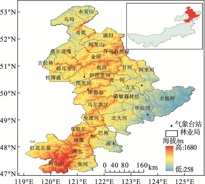
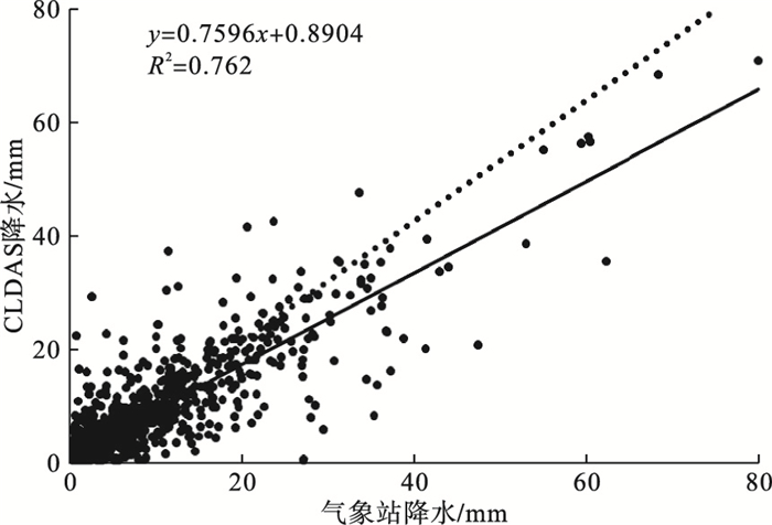
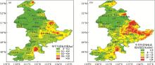
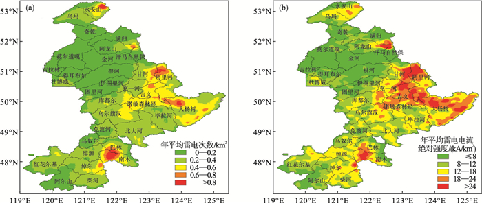
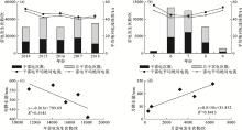
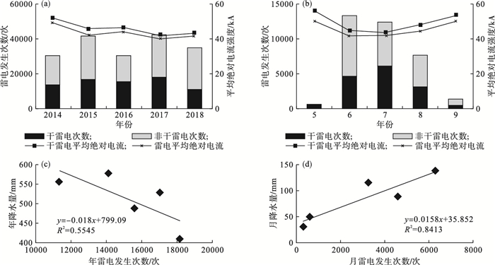
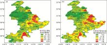
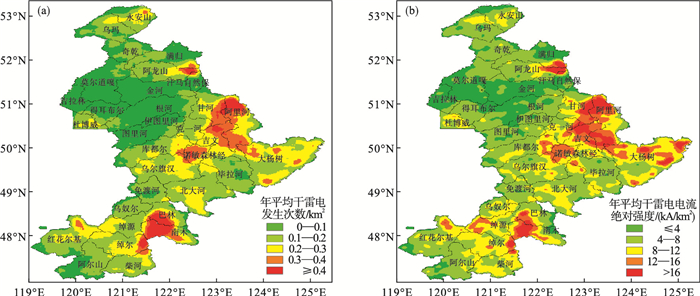
利用2014—2018年内蒙古大兴安岭地区闪电定位仪监测的雷电及CLDAS逐日降水数据,确定干雷电期间降水阈值并筛选干雷电监测数据,分析干雷电在大兴安岭地区的时空分布特征,为大兴安岭地区雷击火的防范提供科学依据。结果表明:大兴安岭地区CLDAS降水与气象站点降水的误差较小,有较高的适用性,可以满足干雷电的分析需求。大兴安岭地区的年平均雷电次数为36013.4次,以负地闪为主,年平均雷电日数为110.4 d,其中有42.3%的雷电发生时的日降水量小于5 mm,宜作为该地区干雷电发生时的降水阈值。以此阈值筛选,大兴安岭地区年平均干雷电发生15229.8次,每年7月年平均干雷电出现次数最多,干雷电的雷电流绝对强度在5月和9月较强。该地区林业局中,永安山东部、满归南部、阿龙山东部、汗马自然保护区北部、甘河东部、阿里河西部、吉文北部、大杨树东南部、巴林南部、南木、绰尔东部等地的年平均干雷电次数达到0.4次/km2,且雷电流绝对强度也普遍偏强,是大兴安岭干雷电的高发区域,应加强上述地区干雷电的日常监测和雷击火防范工作。

关键词: 干雷电, CLDAS, 大兴安岭, 气候响应

Abstract:

Based on the data of lightning and the CLDAS (CMA Land Data Assimilation System) daily precipitation monitored at the lightning locators in the Greater Khingan Mountains of Inner Mongolia Autonomous Region from 2014 to 2018, the precipitation threshold during the dry lightning period was determined and the data of dry lightning monitoring was screened to analyze the spatio-temporal distribution characteristics of dry lightning in the Greater Khingan Mountains, to provide a scientific basis for the prevention of lightning fire in the Greater Khingan Mountains.The results show that the precipitation error between the CLDAS and meteorological stations in the Greater Khingan Mountains is small and has high applicability, which can meet the demand for dry lightning analysis.The annual average lightning frequency in the Greater Khingan Mountains is 36013.4 times, mainly with the negative ground flash.The annual average lightning days are 110.4 d, of which 42.3% of the amount of daily precipitation is less than 5 mm when the lightning occurs, which should be used as the precipitation threshold when dry lightning occurs in this region.According to the screening of this threshold, the annual average dry lightning occurring in the Greater Khingan Mountains is 1, 5229.8 times.The annual average dry lightning occurs mostly in July.The absolute intensity of the dry lightning current in May and September is stronger.Among the Forestry Services in the region, the intensity of the lightning current is generally strong at these regions including the eastern part of Yong'an Mountain, the south of Mangui, the eastern part of Along Mountain, the northern part of the Khanma Nature Reserve, the eastern part of the Ganhe River, the western part of the Ali River, the northern part of the Jiwen, the southeast of the Poplar, the southern part of Bahrain, the South Wood, and the eastern part of Chao'er, with the annual average dry lightning reaching 0.4 times/km2.These regions belong to the high-risk areas for dry lightning.The daily monitoring of dry lightning and the lightning fire prevention work in the above areas should be strengthened.

Key words: Dry lightning, CMA land data assimilation system (CLDAS), Greater Khingan Mountains, Climate response

中图分类号: