主办单位:中国气象局沈阳大气环境研究所
国际刊号:ISSN 1673-503X
国内刊号:CN 21-1531/P

气象与环境学报 ›› 2021, Vol. 37 ›› Issue (4): 122-127.doi: 10.3969/j.issn.1673-503X.2021.04.017

• 论文 • 上一篇    下一篇

辽宁地区一次罕见大雾天气成因分析

王赛頔1(),阎琦2,*(),王晓丽1,腾方达2   

  1. 1. 辽宁省气象服务中心, 辽宁 沈阳 110166
    2. 辽宁省气象台, 辽宁 沈阳 110166
  • 收稿日期:2020-07-14 出版日期:2021-08-30 发布日期:2021-09-10
  • 通讯作者: 阎琦 E-mail:1024309916@qq.com;yq.mete@163.com
  • 作者简介:王赛頔, 女, 1989年生, 工程师, 主要从事天气预报影视制作及气象信息宣传工作, E-mail: 1024309916@qq.com
  • 基金资助:
    辽宁省气象局重点科研项目(201802);中国气象局预报员专项(CMAYBY2016-015);中国气象局预报员专项(CMAYBY2019-024)

Analysis of the cause of rare foggy weather in Liaoning province

Sai-di WANG1(),Qi YAN2,*(),Xiao-li WANG1,Fang-da TENG2   

  1. 1. Liaoning Meteorological Service Center, Shenyang 110166, China
    2. Liaoning Meteorological Observatory, Shenyang 110166, China
  • Received:2020-07-14 Online:2021-08-30 Published:2021-09-10
  • Contact: Qi YAN E-mail:1024309916@qq.com;yq.mete@163.com

摘要:

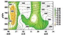
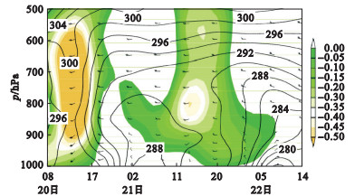
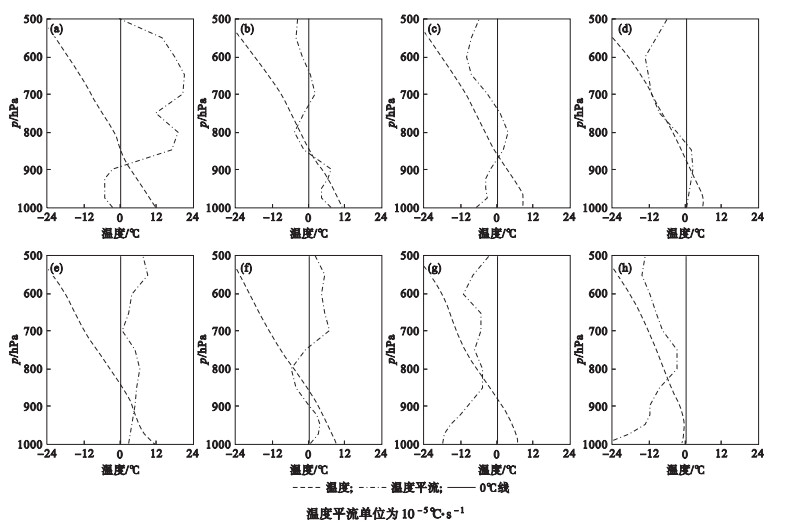
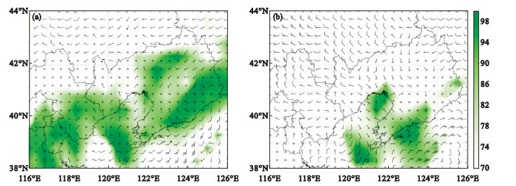
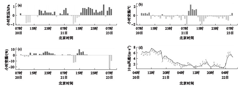
应用常规气象观测、加密自动站、能见度观测等资料和NCEP FNL再分析资料,对2014年辽宁地区一次罕见的长时间大范围强浓雾天气的成因进行诊断。结果表明:2014年11月20-22日辽宁地区大雾过程分为两个阶段,其中21日14-16时大雾爆发性发展后,特强浓雾持续12 h,此种情况在辽宁近20 a比较罕见。大雾第一阶段为辐射雾,雾前低层弱暖平流利于升温,大雾期间中层弱冷平流利于出现晴空辐射条件,夜间在辐射降温作用下,975 hPa高度以下形成逆温;气温下降、温度露点差减小、相对湿度增大;近地面微风利于降温,同时水汽不易流出,逆温作用使得水汽不易向高层扩散,近地面层水汽浓度增大,导致第一阶段大雾快速发展。大雾第二阶段为锋面雾,大雾快速发展期间无逆温、有弱冷锋过境,锋面附近辐合导致水汽上升冷却凝结,同时锋面附近低云降下雨滴在干冷空气中蒸发,利于近地面附近水汽饱和、冷凝,是大雾快速发展的原因。

关键词: 逆温, 辐射雾, 锋面雾

Abstract:

Using conventional meteorological observations, intensive automatic stations, visibility observation data, and NCEP-FNL reanalysis data, the cause of a rare long-term large-scale foggy weather in Liaoning province was analyzed. The results showed that the process of heavy fog on November 20 to 22, 2014 is divided into two phases. After the explosive development of the fog at 14-16 o'clock on November 21, the extremely dense fog lasts 12 hours. This situation is rare in Liaoning province for nearly 20 years. The first stage of heavy fog is radiation fog. The weak warm advection in the lower layer before the fog is conducive to warming up. The weak cold advection in the middle layer during the fog is conducive to the occurrence of clear sky radiation conditions. Under the action of radiation cooling at night, a temperature inversion is formed below 975 hPa. The temperature drops, the temperature dew point difference decreases, and the relative humidity increases. The near-surface breeze is beneficial to reduce the temperature and the water vapor is not easy to flow out. The temperature inversion effect makes it difficult for the water vapor to diffuse to the upper layer, and the concentration of water vapor near the surface layer increases, resulting in the explosive development of the first stage of fog. The second stage of heavy fog is frontal fog. During the explosive development stage of heavy fog, there is no temperature inversion. A weak cold front passes, and convergence near the front causes water vapor to rise and cool and condense. At the same time, low clouds near the front cause raindrops to evaporate in the dry and cold air, which is conducive to water vapor saturation and condensation near the ground. This is the cause of the explosive development of heavy fog. It is relatively rare in Liaoning province.

Key words: Temperature inversion, Radiation fog, Frontal fog

中图分类号: