| 1 |
支星, 谈建国, 孙兰东. 1961—2017年中国华东区域高空温度变化特征[J]. 气象与环境学报, 2021, 37 (2): 48- 55.
doi: 10.3969/j.issn.1673-503X.2021.02.007
|
| 2 |
金巍, 刘卫华, 李晶, 等. 1951—2017年鞍山市气温变化特征及城市热岛变化[J]. 气象与环境学报, 2021, 37 (4): 78- 85.
doi: 10.3969/j.issn.1673-503X.2021.04.011
|
| 3 |
敖雪, 赵春雨, 崔妍, 等. 中国东北地区气温变化的模拟评估与未来情景预估[J]. 气象与环境学报, 2021, 37 (1): 33- 42.
|
| 4 |
张仁平, 郭靖, 张云玲. 新疆草地净初级生产力(NPP)空间分布格局及其对气候变化的响应[J]. 生态学报, 2020, 40 (15): 5318- 5326.
|
| 5 |
潘竟虎, 徐柏翠. 中国潜在植被NPP的空间分布模拟[J]. 生态学杂志, 2020, 39 (3): 1001- 1012.
|
| 6 |
陈妮娜, 纪瑞鹏, 米娜, 等. 春玉米生长发育、产量和籽粒品质对减量施氮的响应[J]. 气象与环境学报, 2021, 37 (4): 86- 92.
doi: 10.3969/j.issn.1673-503X.2021.04.012
|
| 7 |
黄丽艳, 闫巧玲, 高添, 等. 基于ALOS PALSAR雷达影像的人工林蓄积量估算——以塞罕坝机械林场华北落叶松人工林为例[J]. 生态学杂志, 2015, 34 (9): 2401- 2409.
|
| 8 |
梅晓丹, 毛学刚, 范文义, 等. 基于改进的MT-CLIM模型的中高纬低山丘陵区太阳总辐射模拟——以小兴安岭为例[J]. 测绘工程, 2015, 24 (6): 9- 13.
doi: 10.3969/j.issn.1006-7949.2015.06.003
|
| 9 |
李雨鸿, 陶苏林, 李荣平, 等. 辽宁省净初级生产力时空演变及其对地形因子的响应[J]. 气象与环境学报, 2021, 37 (5): 107- 112.
doi: 10.3969/j.issn.1673-503X.2021.05.016
|
| 10 |
谭剑波, 李爱农, 雷光斌. 青藏高原东南缘气象要素Anusplin和Cokriging空间插值对比分析[J]. 高原气象, 2016, 35 (4): 875- 886.
|
| 11 |
冯锦明, 赵天保, 张英娟. 基于台站降水资料对不同空间内插方法的比较[J]. 气候与环境研究, 2004, 9 (2): 261- 277.
|
| 12 |
任璇, 郑江华, 穆晨, 等. 不同气象插值方法在新疆草地NPP估算中的可靠性评价[J]. 草业科学, 2017, 11 (3): 439- 448.
|
| 13 |
王丽娜. 气象要素空间插值算法的研究及其应用[D]. 重庆: 重庆理工大学, 2014.
|
| 14 |
Wong K W , Wong P M , Gedeon T D , et al. Rainfall prediction model using soft computing technique[J]. Soft Computing, 2003, 7 (6): 434- 438.
doi: 10.1007/s00500-002-0232-4
|
| 15 |
吴昌广, 林德生, 周志翔, 等. 三峡库区降水量的空间插值方法及时空分布[J]. 长江流域资源与环境, 2010, 19 (7): 752- 758.
|
| 16 |
钱永兰, 吕厚荃, 张艳红. 基于ANUSPLIN软件的逐日气象要素插值方法应用与评估[J]. 气象与环境学报, 2010, 26 (2): 7- 15.
|
| 17 |
赵美艳, 余君, 胡芸芸. 基于局部薄盘光滑样条函数的重庆地区气温空间插值[J]. 陕西气象, 2021, (1): 50- 55.
|
| 18 |
Burrough P A , McDonnell R A . Principles of geographical information systems[M]. New York, USA: Oxford University Press, 1998: 12- 16.
|
| 19 |
Atkinson P M , Lloyd C D . Mapping precipitation in Switzerland with ordinary and indicator Kriging[J]. Journal of Geographic Information and Decision Analysis, 1998, 2 (2): 72- 86.
|
| 20 |
李任君, 高懋芳, 李强, 等. 基于ANUSPLIN的降水空间插值方法研究[J]. 中国农业信息, 2019, 31 (1): 48- 57.
|
| 21 |
林忠辉, 莫兴国, 李宏轩, 等. 中国陆地区域气象要素的空间插值[J]. 地理学报, 2002, 57 (1): 47- 56.
|
| 22 |
李军, 游松财, 黄敬峰. 中国1961—2000年月平均气温空间插值方法与空间分布[J]. 生态环境, 2006, 15 (1): 109- 114.
|
| 23 |
关宏强, 蔡福, 王阳, 等. 短时间序列气温要素空间插值方法精度的比较研究[J]. 气象与环境学报, 2007, 23 (5): 13- 16.
|
| 24 |
许民, 王雁, 周兆叶, 等. 长江流域逐月气温空间插值方法的探讨[J]. 长江流域资源与环境, 2012, 21 (3): 327- 334.
|
| 25 |
李艳, 朱军, 胡亚, 等. 不同插值方法模拟四川省逐月降水量的对比分析[J]. 水土保持研究, 2017, 24 (1): 151- 154.151-154, 160
|
| 26 |
王江, 乐章燕, 廖荣伟, 等. 中国区域温度和降水不同空间插值方法精度对比[J]. 气象与环境学报, 2016, 32 (6): 85- 93.
|
| 27 |
张玮玮, 张眉, 吴杨, 等. 复杂地形下浙江夏季气候要素空间插值方法评价[J]. 干旱气象, 2020, 38 (4): 674- 682.
|
| 28 |
Collins F C. A Comparison of spatial interpolation techniques in temperature estimation[D]. Blacksburg, Virginia: Virginia Tech, 1995.
|
| 29 |
Dubois G . Spatial interpolation comparison 97:Foreword and introduction[J]. Journal of Geographic Information and Decision Analysis, 1998, (2): 1- 10.
|
| 30 |
Bates D M , Lindstrom M J , Wahba G . Gcvpack-routines for generalized cross validation[J]. Communications in Statistics-Simulation and Computation, 1987, 16 (1): 263- 297.
|
| 31 |
Hutchinson M F. ANUSPLIN version 4.3[M]. Canberra, Australia: The Australia National University, 2004.
|
| 32 |
刘志红, LiL T, McVicarT R, 等. 专用气候数据空间插值软件ANUSPLIN及其应用[J]. 气象, 2008, 34 (2): 92- 100.
|
| 33 |
刘志红, McVicarT R, LiL T, 等. 基于ANUSPLIN的时间序列气象要素空间插值[J]. 西北农林科技大学学报: 自然科学版, 2008, 36 (10): 227- 234.
|
| 34 |
李章林, 王平, 张夏林. 距离幂次反比法的改进与应用[J]. 金属矿山, 2008, (4): 88- 92.
|
| 35 |
郭婧. 基于AMMRR插值法的中国草地综合顺序分类图的研制[D]. 兰州: 甘肃农业大学, 2011.
|
| 36 |
汤国安, 杨昕. ArcGIS地理信息系统空间分析实验教程[M]. 北京: 科学出版社, 2006: 309- 428.
|
| 37 |
朱会义, 贾绍凤. 降雨信息空间插值的不确定性分析[J]. 地理科学进展, 2004, 23 (2): 34- 42.
|
| 38 |
李朝奎, 陈良, 王勇. 降雨量分布的空间插值方法研究——以美国爱达荷州为例[J]. 矿产与地质, 2007, 21 (6): 684- 687.
|
| 39 |
徐翔, 许瑶, 孙青青, 等. 复杂山地环境下气候要素的空间插值方法比较研究[J]. 华中师范大学学报: 自然科学版, 2018, 52 (1): 122- 129.
|
| 40 |
翁笃鸣, 罗哲贤. 山区地形气候[M]. 北京: 气象出版社, 1990.
|
| 41 |
曾燕, 邱新法, 潘敖大, 等. 地形对黄河流域太阳辐射影响的分析研究[J]. 地球科学进展, 2008, 23 (11): 1185- 1193.
|
| 42 |
廖荣伟, 曹丽娟, 张冬斌, 等. 中国地面气温和降水网格化数据精度比较[J]. 气象科技, 2017, 45 (2): 364- 374.
|
| 43 |
Smith R B . The influence of mountains on the atmosphere[J]. Advances in Geophysics, 1979, 21, 87- 230.
|
| 44 |
鲁振宇, 杨太保, 郭万钦. 降水空间插值方法应用研究——以黄河源区为例[J]. 兰州大学学报: 自然科学版, 2006, 42 (4): 11- 14.
|
| 45 |
郑小波, 罗宇翔, 于飞, 等. 西南复杂山地农业气候要素空间插值方法比较[J]. 中国农业气象, 2008, 29 (4): 458- 462.
|
| 46 |
彭红兰, 刘芳, 朵海瑞, 等. 三江源地区温度和降水量空间插值方法比较[J]. 安徽农业科学, 2010, 38 (18): 9646- 9649.9646-9649, 9680
|
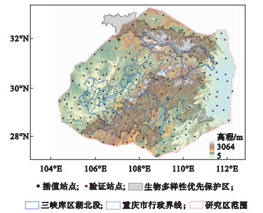
 ),郑莉1,黄河清1,雷波1,杨硕2,刘建辉1,张明阳3,*(