| 1 |
李崇银. 气候动力学引论[M]. 北京: 气象出版社, 2000.
|
| 2 |
李颍莎, 晏惠芬, 莫芳, 等. 西昌2014年大气边界层风场特征分析[J]. 西昌学院学报, 2015, 29 (4): 55- 62.
|
| 3 |
唐学海, 王军, 肖志明. 弹道式再入航天器落点预报技术[J]. 南京航空航天大学学报, 2019, 51 (Z1): 145- 148.
|
| 4 |
赵洪伟, 舒海龙, 王倩, 等. 科尔沁草原高空风垂直结构气候特征分析[J]. , 沙漠与绿洲气象, 2020, 14 (1): 72- 79.
|
| 5 |
张明, 杜裕, 廖雪萍. 基于探空秒级数据的鄂西南高空风特征分析[J]. 气象研究与应用, 2018, 39 (1): 85- 90.
|
| 6 |
李刚, 钱保贵, 刘清芳, 等. 滇东南高空风季节变化特征分析[J]. 气象研究与应用, 2012, 33 (Z1): 68- 70.
|
| 7 |
王娜, 高振铎. 高空气象探测系统现状分析与未来发展[J]. 黑龙江科学, 2017, 8, 23- 24.
|
| 8 |
程炳岩, 河南气候概论[M]. 北京: 气象出版社, 1995[M].
|
| 9 |
程炳岩, 庞天荷. 河南气象灾害与防御[M]. 北京: 气象出版社, 1994.
|
| 10 |
杨程, 董美莹, 陈锋, 等. 浙江多源资料高空风对比分析[J]. 沙漠与绿洲气象, 2018, 12 (4): 74- 81.
|
| 11 |
支星, 谈建国, 孙兰东. 1961—2017年中国华东区域高空温度变化特征[J]. 气象与环境学报, 2021, 37 (2): 48- 55.
|
| 12 |
武小云. 济源市水土保持生态建设分析[J]. 河南水利与南水北调, 2016, 4, 18- 19.
|
| 13 |
纪华, 高振铎, 朱春祥. L波段雷达常见问题及处理方法[J]. 黑龙江气象, 2016, 33 (4): 35- 44.
|
| 14 |
薛改萍, 郭艺楠. 简述L波段高空气象探测资料审核方法[J]. 西藏科技, 2019, 314 (5): 52- 53.
|
| 15 |
李宇凡, 徐士琦, 裘祝香, 等. 吉林省盛夏降水季内变化特征及大气环流分析[J]. 气象与环境学报, 2021, 37 (2): 27- 32.
|
| 16 |
单丹, 朱国光, 胡航菲. 基于GrADS的NCEP/FNL再分析资料自动化处理程序设计与实现[J]. 气象与环境科学, 2018, 41 (4): 133- 139.
|
| 17 |
桂海林, 秦贺, 赵培涛, 等. 2018年春季北京一次沙尘天气边界层特征及来源分析[J]. 气象与环境学报, 2021, 37 (4): 18- 25.
|
| 18 |
Ye D , Tao S , Li M . The abrupt change of circulation over the Northern Hemisphere during June and October, The Atmosphere and the Sea in Motion[M]. Oxford: The Rockefeller Institute Press and Oxford University Press, 1959: 249- 267.
|
| 19 |
张东凌, 赵艳玲, 张铭. 亚洲热带夏季风建立时风场相似度的分析[J]. 气象与环境学报, 2018, 34 (5): 100- 107.
|
| 20 |
田庆明, 马廷德, 杜岩. 酒泉地区高空风速分布特征及其影响因素[J]. 干旱区研究, 2009, 5, 671- 675.
|
| 21 |
李伟, 李书严, 王建凯, 等. 中国地区高空气象探测气球空间漂移分析[J]. 气象学报, 2010, 68 (3): 421- 427.
|
| 22 |
敖雪, 翟晴飞, 崔妍, 等. 1971—2015年辽宁省海岸带大风时空分布特征及成因分析[J]. 气象与环境学报, 2018, 34 (5): 108- 118.
|
| 23 |
王超, 韦志刚, 李振超. 敦煌隔壁地区近地层风的变化特征[J]. 高原气象, 2011, 30 (2): 299- 308.
|
| 24 |
谢今范, 刘玉英, 李宇凡. 吉林地面和高空风速变化特征及成因分析[J]. 高原气象, 2015, 34 (5): 1424- 1434.
|
| 25 |
刘和平, 代佩玲. 河南大风灾害分布特征及成因分析[J]. 气象与环境科学, 2008, 31 (Z1): 135- 137.
|
| 26 |
朱玉周, 吕晓娜, 廖荣伟. 2017年秋季河南罕见连阴雨天气特征及成因分析[J]. 气象与环境学报, 2019, 35 (4): 16- 24.
|
| 27 |
黄骄文, 金啟华, 徐海明, 等. 东亚季风环流由夏向冬的季节转变与中国前冬气候的关系[J]. 气象与环境科学, 2018, 41 (3): 11- 20.
|
| 28 |
林璇, 赵磊, 李得勤, 等. 华北"7·20"特大暴雨多尺度特征分析[J]. 气象与环境学报, 2020, 36 (3): 1- 9.
|
| 29 |
杜明哲, 鲁坦, 朱玉周, 等. 1961—2019年河南秋季连阴雨天气气候特征分析[J]. 气象与环境学报, 2021, 37 (4): 54- 62.
|
| 30 |
胡玉梅, 彭保宏, 陈兴周, 等. 济源市强降水事件的气候变化特征[J]. 气象与环境科学, 2008, 31 (Z1): 15- 17.
|
| 31 |
脱宇峰, 潘攀, 张丽娟, 等. 济源市能见度特征及其影响因素分析[J]. 气象与环境科学, 2012, 35 (1): 56- 61.
|
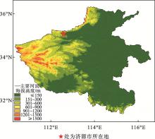
 ),邵铭1,*(