主办单位:中国气象局沈阳大气环境研究所
国际刊号:ISSN 1673-503X
国内刊号:CN 21-1531/P
国际刊号:ISSN 1673-503X
国内刊号:CN 21-1531/P
Journal of Meteorology and Environment ›› 2020, Vol. 36 ›› Issue (6): 10-20.doi: 10.3969/j.issn.1673-503X.2020.06.002
Previous Articles Next Articles
Duan-yu ZHANG( ),Fei-yang WANG,Jin-tao YE
Received:2019-07-25
Online:2020-12-30
Published:2021-01-06
CLC Number:
Duan-yu ZHANG, Fei-yang WANG, Jin-tao YE. Characteristics of rainstorms in central Huanghuai area influenced by a landing tropical cyclone "Rumbia" in 2018[J]. Journal of Meteorology and Environment, 2020, 36(6): 10-20.
Fig.1
Spatial distribution of rainstorms influenced by "Rumbia" in the central and adjacent Huanghuai areas from 08:00 on August 17 to 08:00 on August 18(a), and from 08:00 on August 18 to 08:00 on August 19 (b), 2018"
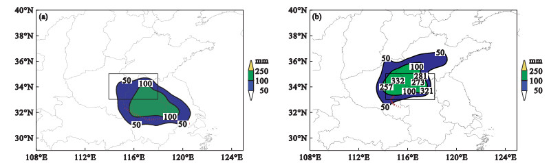
Table 1
Statistical information of precipitation at national automatic weather stations in the central Huanghuai area from 02:00 on August 17 to 14:00 on August 19, 2018"
| 时段 | 短时强降雨/站次 | 单站最大小时雨量/mm | 最大6 h雨量/mm | 47站平均6 h雨量/mm |
| 17日02—08时 | 0 | 9.1 | 安徽灵璧11.2 | 0.7 |
| 17日09—14时 | 0 | 4.6 | 江苏睢宁6.7 | 0.8 |
| 17日15—20时 | 1 | 21.4 | 安徽五河49.6 | 3.2 |
| 17日21时至18日02时 | 1 | 28.1 | 安徽五河72.2 | 8.8 |
| 18日03—08时 | 19 | 48.1 | 安徽濉汐147.1 | 36.2 |
| 18日09—14时 | 31 | 93.9 | 河南商丘208.4 | 53.5 |
| 18日15—20时 | 27 | 66.8 | 安徽灵璧150.6 | 50.4 |
| 18日21时至19日02时 | 16 | 68.5 | 安徽灵璧170.2 | 34.4 |
| 19日03—08时 | 4 | 67.2 | 江苏丰县124.1 | 11.0 |
| 19日09—14时 | 1 | 26.2 | 河南杞县28.7 | 6.2 |
Fig.2
Spatial distribution of TBB over the central and adjacent Huanghuai areas at 11:00 (a) and 12:00 (b) on August 18, 2018"
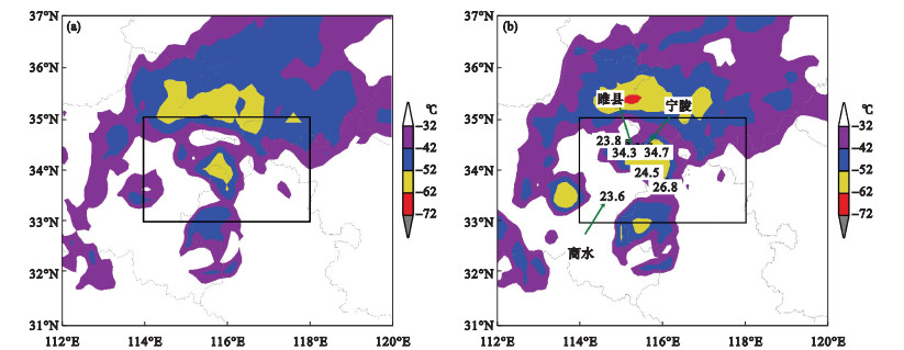
Table 2
Characteristics of TBB during a short-time rainstorm in the central Huanghuai area from 08:00 on August 17 to 08:00 on August 19, 2018"
| 主要类型特征 | 站次数/站次 | 雨量区间/mm | 雨量均值/mm |
| 非对流云 | 13 | 20.4—53.6 | 30.6 |
| 对流云前边界 | 7 | 20.6—93.9 | 40.1 |
| 对流云后边界 | 27 | 20.3—67.2 | 31.0 |
| 对流云“列车效应” | 20 | 20.6—91.6 | 32.9 |
| 对流云核心区 | 28 | 20.6—68.5 | 35.3 |
| 对流云合并 | 4 | 23.8—40.5 | 29.9 |
| 合计 | 99 | 20.3—93.9 | 33.1 |

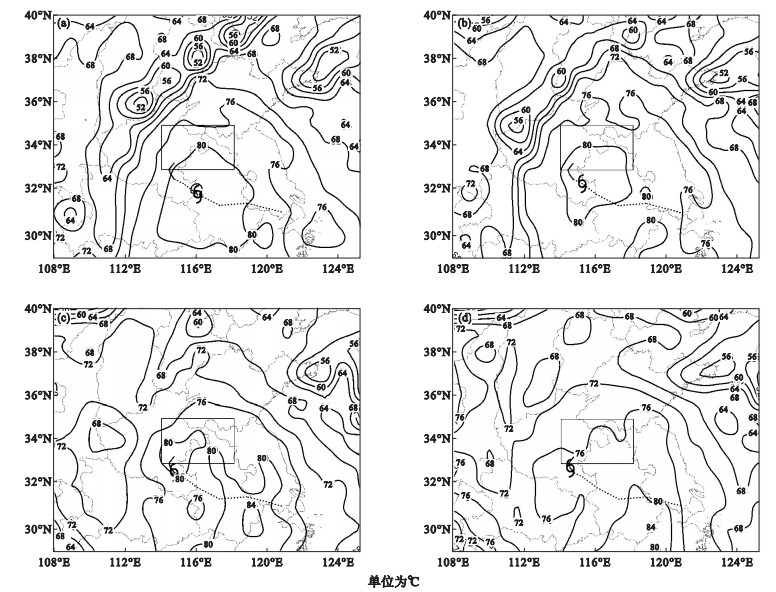
Fig.3
Variation of meso-scale systems influencing rainstorms over the central Huanghuai area at 08:00 (a) and 20:00 (b) on August 17, at 08:00(c) and 20:00 (d) on August 18, and at 08:00 on August 19 (e), 2018"
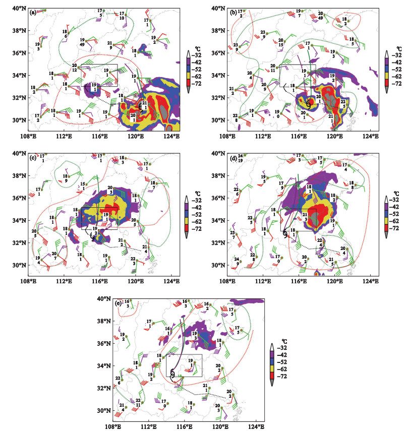
Fig.4
Spatial distribution of sea level pressure over the central and adjacent Huanghuai areas at 08:00 on August 17 (a), 18 (b), and 19 (c), 2018"

Table 3
Variation of vertical wind shear, static stability, precipitable water vapor and 12-h precipitation at a sounding station in Xuzhou from 08:00 on August 17 to 08:00 on August 19, 2018"
| 时间 | VWS1/(m·s-1) | VWS2/(m·s-1) | VWS3/(m·s-1) | A/℃ | k/℃ | SI/℃ | PW/mm | 12 h雨量/mm |
| 17日08时 | 16.372 | 2.488 | 13.892 | 18.1 | 38.2 | -1.26 | 67.7714 | 0.2 |
| 17日20时 | 22.605 | 9.935 | 13.563 | 16.7 | 37.0 | -0.37 | 68.8107 | 12.1 |
| 18日08时 | 26.280 | 19.884 | 14.428 | 16.5 | 37.1 | -0.69 | 69.8852 | 30.2 |
| 18日20时 | 27.251 | 12.244 | 18.185 | 14.4 | 37.8 | -1.30 | 60.9704 | 52.0 |
| 19日08时 | 14.723 | 10.532 | 12.096 | 19.3 | 39.4 | -1.79 | 70.2617 | 107.4 |

Fig.5
Height-time crossing section of divergence of water vapor flux averaged over the central Huanghuai area from 08:00 on August 16 to 08:00 on August 20, 2018"
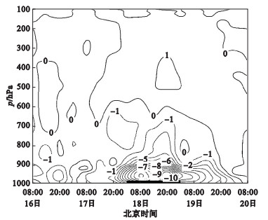
Fig.6
Spatial distribution of divergence of water vapor flux in the central and adjacent Huanghuai areas at 925 hPa at 02:00 (a), 08:00 (b), 14:00 (c), and 20:00 (d) on August 18, 2018"

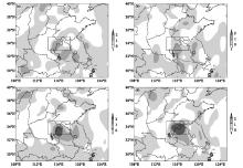
Fig.7
Spatial distribution of divergence of water vapor flux in the central and adjacent Huanghuai areas at 400 hPa at 02:00 (a), 08:00 (b), 14:00 (c), and 20:00 (d) on August 18, 2018"
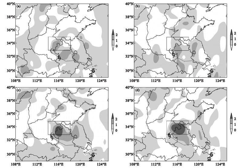

Fig.8
Variation of high-low-level, middle-low-level, and high-middle-level vertical wind shears, and 6-h precipitation averaged over the central Huanghuai area from 08:00 on August 17 to 08:00 on August 19, 2018"
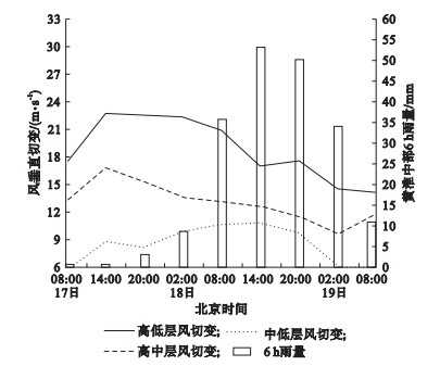
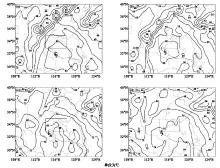
Fig.9
Variation of equivalent potential temperature at 850 hPa in the central and adjacent Huanghuai areas at 02:00 (a), 08:00 (b), 14:00 (c), and 20:00 (d) on August 18, 2018"
| 1 |
Bai L Q , Meng Z Y , Huang L , et al. An integrated damage, visual, and radar analysis of the 2015 Foshan, Guangdong, EF3 tornado in China produced by the landfalling Typhoon Mujigae(2015)[J]. Bulletin of the American Meteorological Society, 2017, 98 (12): 2619- 2640.
doi: 10.1175/BAMS-D-16-0015.1 |
| 2 | Jiang X L , Ren F M , Li Y J , et al. Characteristics and preliminary causes of tropical cyclone extreme rainfall events over Hainan Island[J]. Advances in Atmospheric Sciences, 2018, 35 (5): 580- 591. |
| 3 | 吴志彦, 李宏江, 赵海军, 等. 卫星水汽图像和位势涡度场在一次变性台风暴雨过程中的解译应用[J]. 气象与环境学报, 2018, 34 (3): 1- 8. |
| 4 |
Ren F M , Qiu W Y , Ding C C , et al. An objective track similarity index and its preliminary application to predicting precipitation of landfalling tropical cyclones[J]. Weather and Forecasting, 2018, 33 (6): 1725- 1742.
doi: 10.1175/WAF-D-18-0007.1 |
| 5 | 程航, 李燕, 蔡冬梅. 大连两次台风暴雨过程对比分析[J]. 气象与环境学报, 2019, 35 (3): 1- 9. |
| 6 | 金良浩, 王能根, 赵雅静. 湖北省咸宁市台风低压暴雨预报方法初探[J]. 暴雨灾害, 2008, 27 (2): 149- 153, 165. |
| 7 | 陈宣淼, 余贞寿, 叶子祥. 浙南闽北登陆台风发生区域性暴雨增幅的环境场特征分析[J]. 暴雨灾害, 2018, 37 (3): 246- 256. |
| 8 | 戴竹君, 吴海英, 姜有山, 等. 登陆台风"杰拉华"与"海葵"降雨差异的水汽输送特征[J]. 气象与环境学报, 2018, 34 (5): 16- 24. |
| 9 | 梁军, 张胜军, 李婷婷, 等. 台风布拉万(1215)北上引发辽东半岛强降水的诊断分析[J]. 干旱气象, 2018, 36 (6): 990- 996. |
| 10 | 林小红, 吴建成, 刘通易, 等. 三个典型登闽空心结构台风强降水分布差异分析[J]. 气象与环境学报, 2019, 35 (1): 10- 17. |
| 11 | 史得道, 易笑园, 刘彬贤. 台风"达维"不对称结构特征分析[J]. 气象与环境学报, 2014, 30 (3): 10- 17. |
| 12 | 岳彩军, 韩志惠, 顾问, 等. "海棠"台风(2005)暴雨及其非对称分布特征成因研究[J]. 暴雨灾害, 2017, 36 (4): 293- 300. |
| 13 | 王皘, 张玲. 2018年8月大气环流和天气分析[J]. 气象, 2018, 44 (11): 1501- 1508. |
| 14 | 费增坪, 郑永光, 王洪庆. 2003年淮河大水期间MCS的普查分析[J]. 气象, 2005, 31 (12): 18- 22. |
| 15 | 郑永光, 陈炯, 费增坪, 等. 2003年淮河流域持续暴雨的云系特征及环境条件[J]. 北京大学学报:自然科学版, 2007, 43 (2): 157- 165. |
| 16 | 祁秀香, 郑永光. 2007年夏季我国深对流活动时空分布特征[J]. 应用气象学报, 2009, 20 (3): 286- 294. |
| 17 | 叶日新, 吴立广. 1998-2009年间台风不活跃期间热带云团活动分析[J]. 气象科学, 2016, 36 (3): 291- 300. |
| 18 | 朱炳海, 王鹏飞, 束家鑫. 气象学词典[M]. 上海: 上海辞书出版社, 1985: 1001- 1010. |
| 19 | 刘健文, 郭虎, 李耀东, 等. 天气分析预报物理量计算基础[M]. 北京: 气象出版社, 2005: 27- 83. |
| 20 | 张端禹, 崔春光, 徐明, 等. 2015年湖北省梅雨期一次暴雨过程对流云活动分析[J]. 气象与环境学报, 2017, 33 (2): 8- 17. |
| 21 | 吴蓁, 范学峰, 郑世林, 等. 台风外围偏东气流中的暴雨及其等熵位涡特征[J]. 高原气象, 2008, 27 (3): 584- 595. |
| 22 | 丁一汇. 高等天气学[M]. 2版 北京: 气象出版社, 2005: 138- 149. |
| 23 | 朱乾根, 林锦瑞, 寿绍文, 等. 天气学原理与方法[M]. 3版 北京: 气象出版社, 2000: 507- 555. |
| [1] | YAO Jing, JING Yu, LIU Yong, ZHAO Qiang, WANG Nan. Analyses of the mechanisms of the first regional snowstorm associated with an “Elevated Thunderstorm” over Shaanxi province in 2016 [J]. Journal of Meteorology and Environment, 2018, 34(6): 24-32. |
| [2] | SHEN Yang, SHEN An-yun, SU Hang, XIONG Shi-wei, YAN Wen-lian. Causes analysis on a large-range dense fog event in the winter of 2016 over Jiangsu province [J]. Journal of Meteorology and Environment, 2017, 33(4): 11-20. |
| [3] | XIAO Liu-si, CHEN Zhi-gang, HU Dong-ming, LIAO Fei. Characteristic analysis of a tornado developing from the super-typhoon “Mujigae” [J]. Journal of Meteorology and Environment, 2017, 33(3): 21-28. |
| [4] | LIANG Wei-liang, QU Mei-fang, LAI Zhen-quan, NONG Meng-song. Analysis of radar features and environmental background during a severe thunderstorm in early summer 2014 in Guangxi Zhuang Autonomous Region [J]. Journal of Meteorology and Environment, 2016, 32(3): 10-18. |
| [5] | LI Da-wei,LIANG Hong,JIA Dong-chan,XIA Chuan-dong,ZHAO Liu-yang,MENG Peng. Doppler weather radar echo characteristics in a short-term heavy rain on July 14, 2011 in Shenyang [J]. Journal of Meteorology and Environment, 2013, 29(2): 75-80. |
| [6] | ZHAO Ya-xuan;LIANG Jun;SHI Xiao-long;ZHU Jing;LIU Xiao-chu. Comparison between rain to blizzard process and heavy snow process during late winter 2009 in Liaoning province [J]. Journal of Meteorology and Environment, 2010, 26(5): 30-35. |
| Viewed | ||||||
|
Full text |
|
|||||
|
Abstract |
|
|||||
|