主办单位:中国气象局沈阳大气环境研究所
国际刊号:ISSN 1673-503X
国内刊号:CN 21-1531/P
国际刊号:ISSN 1673-503X
国内刊号:CN 21-1531/P
Journal of Meteorology and Environment ›› 2021, Vol. 37 ›› Issue (4): 9-17.doi: 10.3969/j.issn.1673-503X.2021.04.002
• Articles • Previous Articles Next Articles
Yan-jie LIU( ),Qing-chuan WANG,Min XU,He-ling ZHOU
Received:2020-08-01
Online:2021-08-30
Published:2021-09-10
CLC Number:
Yan-jie LIU,Qing-chuan WANG,Min XU,He-ling ZHOU. Characteristics and causes of a high precipitation supercell in Beijing in May of 2019[J]. Journal of Meteorology and Environment, 2021, 37(4): 9-17.
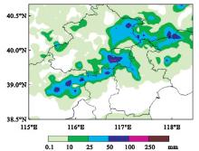
Fig.1
Precipitation in central Beijing-Tianjin- Hebei region from 16:00 on May 17 to 02:00 on May 18, 2019"
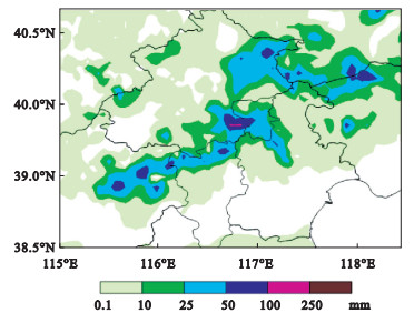
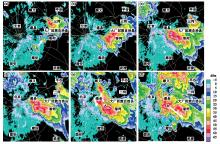
Fig.2
Radar reflectivity at the 2.4° elevation angle at 17:00 (a), 17:30 (b), 18:00 (c), 18:12 (d), 18:30 (e), and 19:00 (f) measured by Doppler weather radar in Beijing on May 17, 2019"
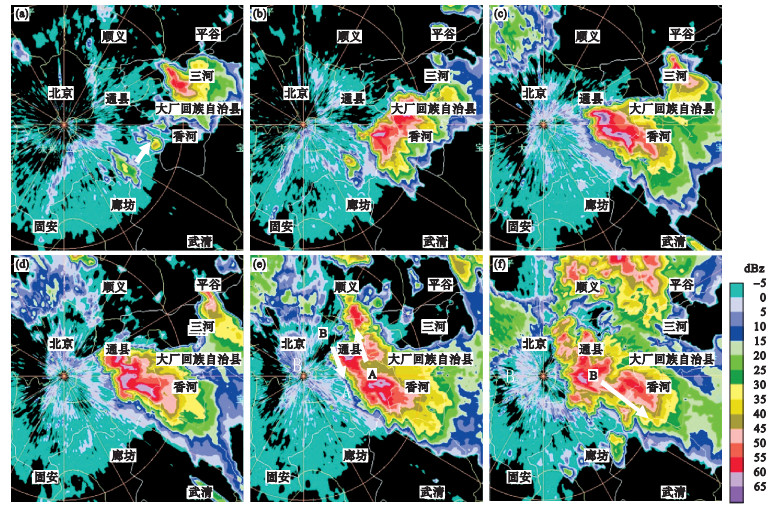
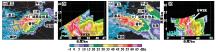
Fig.3
Radar reflectivity at the 2.4° elevation angle at 17:36 (a), 18:12 (c), and crossing section of radar reflectivity along the white contours at 17:36 (b), 18:12 (d) on May 17, 2019 in Beijing"
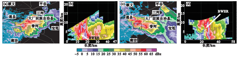

Fig.4
Radial velocity (a) and radar reflectivity (b) at the 1.5° elevation angle at 18:24 on May 17, 2019 in Beijing"
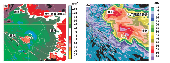

Fig.5
Composite weather map at 08:00 on May 17, 2019"
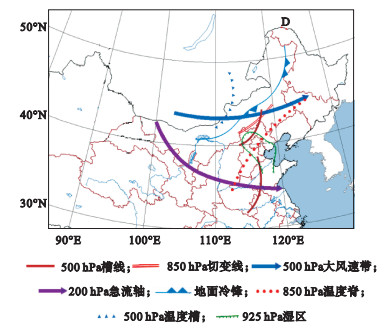
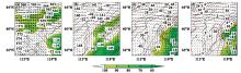
Fig.6
Composite map of wind field, geopotential height, temperature and relative humidity at 500 hPa (a), 850 hPa (b), 950 hPa (c), and 1000 hPa (d) at 14:00 on May 17, 2019"
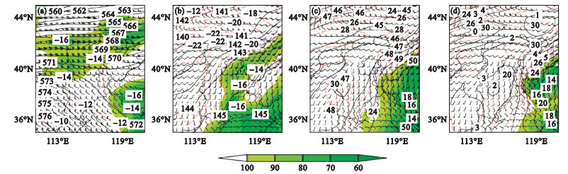
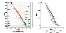
Fig.7
Sounding chart in Beijing at 08:00 (a) and temperature profiles below 3000 m at Dachang station from 14:00 to 18:00 (b) on May 17, 2019"
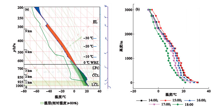
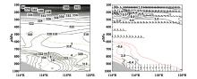
Fig.8
Crossing sections of pseudo-equivalent potential temperature and relative humidity (a), relative vorticity, vertical velocity, and horizontal wind (b) along 39.75°N at 14:00 on May 17, 2019"
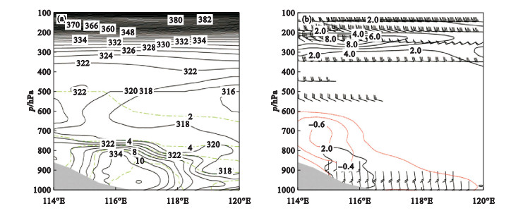
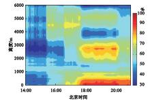
Fig.9
Variation of relative humidity at Dachang station from 14:00 to 21:00 on May 17, 2019"
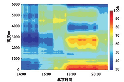
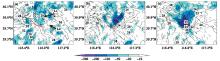
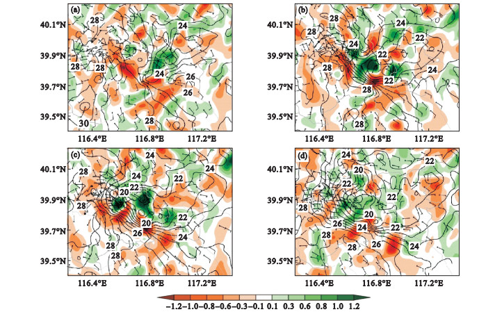
Fig.10
Distribution of surface temperature advection, temperature, and wind in the eastern part of Beijing at 17:30 (a), 18:00 (b), 18:30 (c), and 19:00 (d) on May 17, 2019"
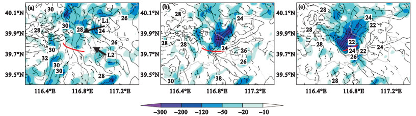
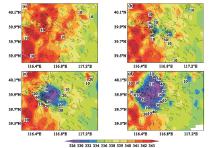
Fig.11
Distribution of surface pseudo-equivalent potential temperature, frontogenesis function, and wind in the eastern part of Beijing at 17:40 (a), 18:10 (b), 18:30 (c), and 19:00 (d) on May 17, 2019"
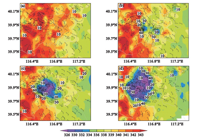

Fig.12
Distribution of divergence, temperature, and wind at automated weather stations in the eastern part of Beijing at 17:40 (a), 18:10 (b), 18:30 (c), and 19:00 (d) on May 17, 2019"
| 1 |
Browning K A . Airflow and precipitation trajectories within severe local storms which travel to the right of the winds[J]. Journal of Atmospheric Science, 1964, 21 (6): 634- 639.
doi: 10.1175/1520-0469(1964)021<0634:AAPTWS>2.0.CO;2 |
| 2 |
Lemon L R , Doswell C A . Severe thunderstorm evolution and mesocyclone structure as related to tornadogenesis[J]. Monthly Weather review, 1979, 107 (9): 1184- 1197.
doi: 10.1175/1520-0493(1979)107<1184:STEAMS>2.0.CO;2 |
| 3 | Doswell C A, Burgess D W. Tornadoes and tornadic storms: a review of conceptual models[M]//Church C, Burgess D, Doswell C, et al. The tornado: Its structure, dyramics, prediction, and hazards, geophysical monograph series, volume 79. Washing DC: American Geophysical Union, 1993: 161-172. |
| 4 |
郑媛媛, 俞小鼎, 方翀, 等. 一次典型超级单体风暴的多普勒天气雷达观测分析[J]. 气象学报, 2004, 62 (3): 317- 328.
doi: 10.3321/j.issn:0577-6619.2004.03.006 |
| 5 |
刘维成, 杨晓军, 史志娟, 等. 一次超级单体风暴的雷达回波特征分析[J]. 干旱气象, 2009, 27 (4): 320- 326.
doi: 10.3969/j.issn.1006-7639.2009.04.004 |
| 6 | 苏爱芳, 梁俊平, 崔丽曼, 等. 豫北一次局地雹暴天气的预警特征和触发机制[J]. 气象与环境学报, 2012, 28 (6): 1- 7. |
| 7 | Yu X D, Wang X M, Zhao J, et al. Investigation of supercells in China: Environmental and storm characteristics[C]//AMS. Proceedings of the 26th Conference on Severe Local Storms. Nashville, TN: American Meteorological Society, 2012. |
| 8 | 王福侠, 俞小鼎, 闫学瑾. 一次超级单体分裂过程的雷达回波特征分析[J]. 气象学报, 2014, 72 (1): 152- 167. |
| 9 |
廖玉芳, 俞小鼎, 唐小新. 2004年4月29日常德超级单体研究[J]. 南京气象学院学报, 2007, 30 (5): 579- 589.
doi: 10.3969/j.issn.1674-7097.2007.05.001 |
| 10 | 郭鸿鸣, 李江波, 李飏, 等. 一次多单体风暴的传播特征及其预警研究[J]. 气象与环境学报, 2017, 33 (4): 1- 10. |
| 11 | 杨晓亮, 杨敏. 2017年秋季河北一次飑线引发的雷暴大风过程[J]. 气象与环境学报, 2020, 36 (6): 1- 9. |
| 12 | 王楠, 李萍云, 井宇, 等. 黄土高原一次超级单体短时强降水中尺度分析[J]. 气象科学, 2016, 36 (6): 742- 751. |
| 13 | 徐璐璐, 李倩, 李慧琳, 等. 2018年9月丹东连续两次风雹天气的多尺度对比分析[J]. 气象与环境学报, 2019, 35 (6): 1- 7. |
| 14 | 胡玲, 张殿江, 吴强. 强弱降水超级单体风暴雷达回波特征对比分析[J]. 气象科技, 2008, 36 (2): 155- 159. |
| 15 | 潘玉洁, 赵坤, 潘益农. 一次强飑线内强降水超级单体风暴的单多普勒雷达分析[J]. 气象学报, 2008, 66 (4): 621- 636. |
| 16 | 吴芳芳, 俞小鼎, 王慧, 等. 一次强降水超级单体风暴多普勒天气雷达特征[J]. 大气科学学报, 2010, 33 (3): 285- 298. |
| 17 | 张玉洁, 苑文华, 徐百言. 江苏阜宁龙卷超级单体风暴的雷达资料分析[J]. 干旱气象, 2019, 37 (3): 409- 418. |
| 18 | 闵锦忠, 贾瑞怡, 王晨珏. 苏北一次强降水超级单体风暴过程的诊断分析[J]. 大气科学学报, 2018, 41 (4): 463- 474. |
| 19 | 张文龙, 崔晓鹏, 黄荣, 等. 北京"623"大暴雨的强降水超级单体特征和成因研究[J]. 大气科学, 2019, 43 (5): 1171- 1190. |
| 20 | 俞小鼎, 姚秀萍, 熊廷南, 等. 多普勒天气雷达原理与业务应用[M]. 北京: 气象出版社, 2006: 112- 114. |
| 21 | 刘艳杰, 周玉都, 马庚雪. 河北廊坊冰雹天气特征统计分析[J]. 气象与环境科学, 2018, 41 (1): 108- 115. |
| 22 | 高帆, 褚颖佳, 胡鹏, 等. 一次长生命史超级单体风暴的雷达观测特征和维持机制[J]. 气象科技, 2018, 46 (2): 336- 342. |
| [1] | Li-man CUI, Ai-fang SU, Yu-xing ZHANG, Chun-xiao WANG, Di WANG. Causes analysis of the formation of an extensive severe convective weather in 2016 in He'nan province [J]. Journal of Meteorology and Environment, 2020, 36(2): 9-19. |
| [2] | SHAN Nai-chao, ZHOU Hou-fu, CHU Bao-liang, ZHAO Qian. Mechanism analysis of thunderstorm gale in Hefei area on May 14,2017 [J]. Journal of Meteorology and Environment, 2019, 35(5): 1-9. |
| [3] | CHEN Xiang-xiang, XU Ai-hua, XU Bin, XIAO An. Characteristics of spatiotemporal distribution and influence elements of three kinds of regional heavy fog in Jiangxi province from 2000 to 2012 [J]. Journal of Meteorology and Environment, 2018, 34(3): 37-47. |
| [4] | SHEN Yang, SHEN An-yun, SU Hang, XIONG Shi-wei, YAN Wen-lian. Causes analysis on a large-range dense fog event in the winter of 2016 over Jiangsu province [J]. Journal of Meteorology and Environment, 2017, 33(4): 11-20. |
| [5] | JIANG Yang, HE Zhi-xin, ZHOU Kun, ZHU Hong-fang, WANG Dong-yong. Analysis of forming reason of freezing rain weather and its characteristics in mountain and plain of Anhui province [J]. Journal of Meteorology and Environment, 2016, 32(2): 11-17. |
| Viewed | ||||||
|
Full text |
|
|||||
|
Abstract |
|
|||||
|