主办单位:中国气象局沈阳大气环境研究所
国际刊号:ISSN 1673-503X
国内刊号:CN 21-1531/P
国际刊号:ISSN 1673-503X
国内刊号:CN 21-1531/P
Journal of Meteorology and Environment ›› 2022, Vol. 38 ›› Issue (2): 1-11.doi: 10.3969/j.issn.1673-503X.2022.02.001
Previous Articles Next Articles
Yao-peng CUI1,2( ),Lei YANG1,3,*(),Li SUN1,Yan-bo GAO2,Hai-ning WEI2,Jing-jing HUA2,Jing-xuan CUI2,Chun-xi LIU2
Received:2020-02-10
Online:2022-04-28
Published:2022-04-24
Contact:
Lei YANG
E-mail:jim19870316@163.com;yanglei_nuist@163.com
CLC Number:
Yao-peng CUI, Lei YANG, Li SUN, Yan-bo GAO, Hai-ning WEI, Jing-jing HUA, Jing-xuan CUI, Chun-xi LIU. Comparison of characteristics and causes of two northward typhoon rainstorms in the Southeast Peninsula of Liaoning province[J]. Journal of Meteorology and Environment, 2022, 38(2): 1-11.
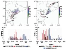
Fig.1
Distribution of cumulative precipitation from 20:00 on August 2 to 08:00 on August 4, 2012, during Process 1 (a) and from 08:00 on August 3 to 20:00 on August 4, 2017, during Process 2 (b), and variation of hourly precipitation at typical stations during Process 1 (c) and Process 2 (d)"
Table 1
Information of precipitation during the two extreme rainstorms in August of 2012 and 2017 in Liaoning province"
| 要素 | 2012年“达维” | 2017年“海棠” |
| 主要降水时段 | 2012年8月2日20:00—4日08:00 | 2017年8月3日20:00—4日20:00 |
| 持续时间 | 持续时间长达30 h,主要降水出现3日02:00—4日08:00 | 持续时间仅仅12 h,主要降水时段出现在3日20:00—4日08:00 |
| 最大过程降水量及发生地 | 庄河市仙人洞镇,330 mm | 岫岩县哨子河乡马岭村,503 mm |
| 最大小时雨强及发生地 | 2012年8月3日12:00—13:00瓦房店市红沿河镇,51 mm·h-1 | 2017年8月4日06:00—07:00岫岩县哨子河乡永贵村,113 mm·h-1 |
| 暴雨移动路径 | 从辽宁南部向北部移动 | 从辽宁南部向东移动 |
| 小时降雨量超过50 mm 站次/超过100 mm站次 | 9/0 | 125/1 |
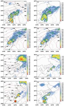
Fig.2
Distribution of temperature of black body (TBB) at 05:00 (a), TBB and geopotential height at 500 hPa at 08:00 (b), TBB at 12:00 (c), and TBB and geopotential height at 500 hPa at 20:00 (d) on August 3, 2012, in Process 1, and distribution of TBB at 21:00 and geopotential height at 500 hPa at 20:00 on August 3 (e), and TBB at 01:00 (f), TBB at 03:00 and and geopotential height at 500 hPa at 02:00 (g), and TBB at 06:00 (h) on August 4, 2017, in Process 2"
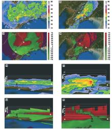
Fig.3
Distribution of reflectivity factor with an elevation of 1.5° measured by a SA radar in Yingkou at 12:17 on August 3, 2012 (Process 1) (a) and at 04:43 on August 4, 2017 (Process 2) (b), and radical velocity in Process 1 (c) and Process 2 (d), and crossing sections of reflectivity factor along the white AB line in Fig. 1a and Fig. 1b in Process 1 (e) and Process 2 (f), and radical velocity in Process 1 (g) and Process 2 (h)"
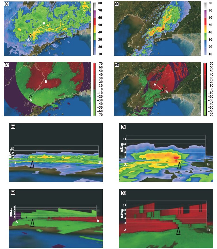
Fig.4
Distribution of wind field and water vapor flux at 850 hPa, and the sea level pressure at 08:00 on August 3, 2012, in Process 1 (a) and at 02:00 on August 4, 2017, in Process 2 (b)"
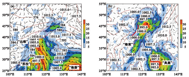
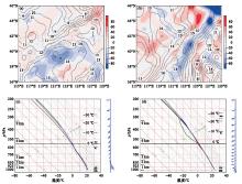
Fig.5
Distribution of water vapor flux divergence and specific humidity at 850 hPa at 08:00 on August 3, 2012, in Process 1 (a) and at 02:00 on August 4, 2017, in Process 2 (b), and the T-logP plots at location 123°E, 40°N at 08:00 on August 3, 2012, in Process 1 (c) and at 02:00 on August 4, 2017, in Process 2 (d)"
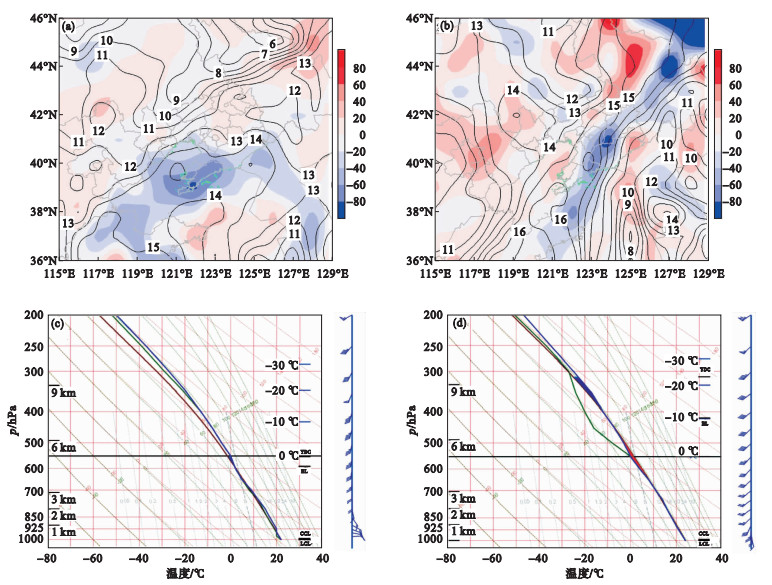
Fig.6
Distribution of potential pseudo-equivalent temperature at 850 hPa and relative humidity at 500 hPa at 08:00 on August 3, 2012, in Process 1 (a) and at 20:00 on August 3, 2017, in Process 2 (b), and crossing sections of potential pseudo-equivalent temperature and winds along the 40°N at 08:00 on August 3, 2012, in Process 1 (c) and at 02:00 on August 4, 2017, in Process 2 (d)"
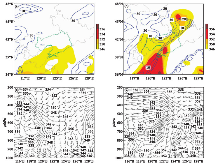
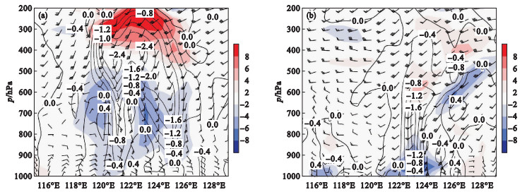
Fig.7
Crossing sections of wind divergence, vertical velocity, and wind field along the 40°N at 08:00 on August 3, 2012 in Process 1 (a) and at 02:00 on August 4, 2017, in Process 2 (b)"
| 1 |
陈传雷, 王江山, 蒋大凯, 等. 登陆辽宁热带气旋特征统计分析[J]. 气象与环境学报, 2012, 28 (3): 1- 7.
doi: 10.3969/j.issn.1673-503X.2012.03.001 |
| 2 | 梁军, 李英, 张胜军, 等. 影响辽东半岛两个台风Meari和Muifa暴雨环流特征的对比分析[J]. 大气科学, 2015, 39 (6): 1215- 1224. |
| 3 | 梁军, 张胜军, 李婷婷, 等. 台风布拉万(1215)北上引发辽东半岛强降水的诊断分析[J]. 干旱气象, 2018, 36 (6): 990- 996. 990-996, 1051 |
| 4 | 陶祖钰, 田佰军, 黄伟. 9216号台风登陆后的不对称结构和暴雨[J]. 热带气象学报, 1994, 10 (1): 69- 77. |
| 5 |
陈联寿, 孟智勇. 我国热带气旋研究十年进展[J]. 大气科学, 2001, 25 (3): 420- 431.
doi: 10.3878/j.issn.1006-9895.2001.03.11 |
| 6 |
周小珊, 杨阳, 杨森, 等. 北上热带气旋气候特征分析[J]. 气象与环境学报, 2007, 23 (6): 1- 5.
doi: 10.3969/j.issn.1673-503X.2007.06.001 |
| 7 | 杨德南, 黄丽娜, 林莉, 等. 1710号台风"海棠"登陆后漳州市远距离暴雨的能量特征[J]. 干旱气象, 2019, 37 (1): 76- 89. |
| 8 | 朱梅, 何君涛, 方勉, 等. GPM卫星资料在分析"杜苏芮"台风降水结构中的应用[J]. 干旱气象, 2018, 36 (6): 997- 1002. |
| 9 | 王文波, 王旭, 杨明, 等. 台风"达维"移动路径成因分析[J]. 干旱气象, 2014, 32 (1): 75- 80. |
| 10 |
钱燕珍, 潘灵杰, 段晶晶, 等. 三个登陆台风间接造成宁波大暴雨特征分析[J]. 气象与环境学报, 2019, 35 (5): 37- 45.
doi: 10.3969/j.issn.1673-503X.2019.05.005 |
| 11 |
陈联寿. 热带气旋研究和业务预报技术的发展[J]. 应用气象学报, 2006, 17 (6): 672- 681.
doi: 10.3969/j.issn.1001-7313.2006.06.005 |
| 12 |
梁军, 陈联寿. 影响辽东半岛热带气旋运动、强度和影响的特征[J]. 热带气象学报, 2005, 21 (4): 410- 419.
doi: 10.3969/j.issn.1004-4965.2005.04.009 |
| 13 |
梁军, 陈联寿, 张胜军, 等. 冷空气影响辽东半岛热带气旋降水的数值试验[J]. 大气科学, 2008, 32 (5): 1107- 1118.
doi: 10.3878/j.issn.1006-9895.2008.05.10 |
| 14 | 陈有利, 钱燕珍, 潘灵杰, 等. 一次与台风相关联的浙江东北部暴雨成因及预报难点分析[J]. 干旱气象, 2018, 36 (2): 272- 281. |
| 15 |
Meng W G , Wang Y Q . A diagnostic study on heavy rainfall induced by Typhoon Utor(2013)in South China.Part Ⅰ: Rainfall asymmetry at landfall[J]. Journal of Geophysical Research: Atmospheres, 2016, 121 (21): 12781- 12802.
doi: 10.1002/2015JD024646 |
| 16 |
Meng W G , Wang Y Q . A diagnostic study on heavy rainfall induced by Typhoon Utor(2013)in South China: 2.Postlandfall rainfall[J]. Journal of Geophysical Research: Atmospheres, 2016, 121 (21): 12803- 12819.
doi: 10.1002/2015JD024647 |
| 17 | 杨磊, 孙丽, 王东东, 等. 2017年"海棠"台风影响辽宁不同区域极端暴雨成因分析[J]. 气象与环境学报, 2020, 36 (1): 1- 10. |
| 18 | 孙继松, 何娜, 王国荣, 等. "7.21"北京大暴雨系统的结构演变特征及成因初探[J]. 暴雨灾害, 2012, 31 (3): 218- 325. |
| 19 | 郝莹, 姚叶青, 郑媛媛, 等. 短时强降水的多尺度分析及临近预警[J]. 气象, 2012, 38 (8): 903- 912. |
| 20 | 杨磊, 蒋大凯, 王瀛, 等. "8·16"辽宁特大暴雨多尺度特征分析[J]. 干旱气象, 2017, 35 (2): 267- 274. |
| 21 | 俞小鼎, 姚秀萍, 熊廷南, 等. 多普勒天气雷达原理与业务应用[M]. 北京: 气象出版社, 2006: 53- 61. |
| 22 | 陈宏, 杨晓君, 尉英华, 等. 干冷空气入侵台风"海棠"残余低压引发的华北地区大暴雨分析[J]. 暴雨灾害, 2020, 39 (3): 241- 249. |
| 23 | 孙欣, 陈力强. 辽宁省高影响天气预报技术[M]. 沈阳: 辽宁省科学技术出版社, 2016: 19- 73. |
| 24 | Doswell III C A . A review for forecasters on the application of hodographs to forecasting severe thunderstorms[J]. National Weather Digest, 1991, 16 (1): 2- 16. |
| 25 | 樊李苗, 俞小鼎. 中国短时强对流天气的若干环境参数特征分析[J]. 高原气象, 2013, 32 (1): 156- 165. |
| 26 | 高守亭, 周玉淑, 冉令坤. 我国暴雨形成机理及预报方法研究进展[J]. 大气科学, 2018, 42 (4): 833- 846. |
| 27 | Gao S T , Yang S , Chen B . Diagnostic analyses of dry intrusion and nonuniformly saturated instability during a rainfall event[J]. Journal of Geophysical Research: Atmospheres, 2010, 115 (D2): D02102. |
| 28 |
Yang S , Gao S T . Modified Richardson number in non-uniform saturated moist flow[J]. Chinese Physics Letters, 2006, 23 (11): 3003- 3006.
doi: 10.1088/0256-307X/23/11/033 |
| 29 | Rossby C G. Thermodynamics applied to air mass analysis[M]//Massachusetts Institute of Technology and the Woods Hole Oceanographic Institution, Papers in Physical Oceanography and Meteorology Cambridge. Massachusetts, USA: Massachusetts Institute of Technology, 1932. |
| 30 |
王秀明, 俞小鼎, 周小刚. 雷暴潜势预报中几个基本问题的讨论[J]. 气象, 2014, 40 (4): 389- 399.
doi: 10.3969/j.issn.1000-6362.2014.04.005 |
| 31 | 吴国雄, 蔡雅萍, 唐晓菁, 等. 湿位涡和倾斜涡度发展[J]. 气象学报, 1955, 53 (4): 387- 405. |
| [1] | REN Li, LUAN Chen, WANG Xiao-xue, ZHANG Yue. Causes and characteristics of a persistent rainstorm event in warm front of a cold vortex [J]. Journal of Meteorology and Environment, 2022, 38(3): 37-44. |
| [2] | Shu-ting CHANG,Xue BAI,Zi-yi QU,Zhou WEN,Yu-xiu XU,Ming GAO,Cui-yan ZHANG. Analysis of precipitation variation and water vapor flux characteristics in summer under the background of global warming in Liaoning province [J]. Journal of Meteorology and Environment, 2021, 37(3): 57-64. |
| [3] | Yan-lan LI,Long JIN,Xu-ming SHI,Dan CHEN. Study on assessment model of typhoon disaster in Guangxi based on genetic-neural network method [J]. Journal of Meteorology and Environment, 2021, 37(3): 139-144. |
| [4] | Xiao-hong LIN,Yi-yong CAI,Mei HAN,Hong GUO,Tong-yi LIU. Comparative analysis of strength variation of double typhoons of "Nesat" and "Haitang" after landing in Fujian province [J]. Journal of Meteorology and Environment, 2021, 37(2): 1-11. |
| [5] | Ting LUO, Yuan-qing WANG, Li-ping LI. Characteristics of typhoon rainfall affecting Hainan Island and its water vapor sources [J]. Journal of Meteorology and Environment, 2020, 36(6): 42-49. |
| [6] | Xiu-juan WANG, Zhong-bao JIANG, Xiao-hua MA, Xu FENG. Causes analysis of heavy rainfall in 2018 in Jilin province [J]. Journal of Meteorology and Environment, 2020, 36(2): 1-8. |
| [7] | Jiang-ling ZHI. Analysis of the tornado weather process of Ewiniar typhoon [J]. Journal of Meteorology and Environment, 2020, 36(2): 20-27. |
| [8] | Lei YANG, Li SUN, Dong-dong WANG, Chuan-lei CHEN, Ying WANG, Kui-zhi CAI, Yue ZHANG. Formation of an extreme rainstorm in different regions of Liaoning province affected by typhoon "Haitang" in 2017 [J]. Journal of Meteorology and Environment, 2020, 36(1): 1-10. |
| [9] | LIN Xiao-hong, WU Xing-yu, CHEN Miao, LI Ya-fen, LIU Jin-xiu, CHEN Bin. Characteristics of strong typhoon wind and typical cases of extreme wind on the west coast of the Taiwan Strait,China [J]. Journal of Meteorology and Environment, 2019, 35(6): 93-100. |
| [10] | QIAN Yan-zhen, PAN Ling-jie, DUAN Jing-jing, GUO Yu-guang, ZHU Xian-chun. Analysis on the characteristics of heavy rainfall in Ningbo indirect caused by three landing typhoons [J]. Journal of Meteorology and Environment, 2019, 35(5): 37-45. |
| [11] | HUANG Hai-jing, YANG Zai-qiang, WANG Chun-yi, ZHANG Jing-hong, ZHANG Ya-jie, ZHANG Ming-jie. Evaluation of typhoon disaster risk for Hevea brasiliensis in Hainan island [J]. Journal of Meteorology and Environment, 2019, 35(5): 130-136. |
| [12] | CHENG Hang, LI Yan, CAI Dong-mei. Comparative analysis of two typhoon rainstorm processes affecting Dalian city [J]. Journal of Meteorology and Environment, 2019, 35(3): 1-9. |
| [13] | LIN Xiao-hong, WU Jian-cheng, LIU Tong-yi, HAN Mei, GUO Hong, KE Xiao-qing. Analysis of heavy rainfall distribution difference among three typical hollow typhoons landing in Fujian province [J]. Journal of Meteorology and Environment, 2019, 35(1): 10-17. |
| [14] | WANG Ye-hong, ZHAO Yu-chun. Impacts of different background error samples simulation schemes on numerical forecast-taking typhoon “Soudelor” as an example [J]. Journal of Meteorology and Environment, 2018, 34(6): 11-23. |
| [15] | HOU Shu-xun, ZHANG Wan-ying, CHEN Zhen, WANG Guan, YUAN Yuan. Diagnostic analysis of a heavy rainfall event due to an eastward-moving northwest vortex [J]. Journal of Meteorology and Environment, 2018, 34(5): 9-15. |
| Viewed | ||||||
|
Full text |
|
|||||
|
Abstract |
|
|||||
|