主办单位:中国气象局沈阳大气环境研究所
国际刊号:ISSN 1673-503X
国内刊号:CN 21-1531/P
国际刊号:ISSN 1673-503X
国内刊号:CN 21-1531/P
Journal of Meteorology and Environment ›› 2022, Vol. 38 ›› Issue (6): 20-28.doi: 10.3969/j.issn.1673-503X.2022.06.003
• Articles • Previous Articles Next Articles
Liang-peng DONG1( ),Ping-ping ZHANG2,*()
Received:2021-02-26
Online:2022-12-28
Published:2022-12-27
Contact:
Ping-ping ZHANG
E-mail:lpdong_21@126.com;zpp7117@126.com
CLC Number:
Liang-peng DONG,Ping-ping ZHANG. Comparison of abnormalism of meteorological factors on two extreme precipitations triggered by low vortex in Hubei province in 2020[J]. Journal of Meteorology and Environment, 2022, 38(6): 20-28.
Table 1
Characteristic of the 24 h precipitation amount of the two rainstorm processes in Hubei province in 2020"
| 指标 | 6月27日24 h降水量 | 7月7日24 h降水量 | |||
| 国家站 | 区域站 | 国家站 | 区域站 | ||
| ≥250 mm站数/站 | 1 | 23 | 1 | 20 | |
| ≥100 mm站数/站 | 16 | 473 | 15 | 344 | |
| 最大降水量/mm | 272.6 | 318.5 | 331.9 | 351.5 | |
| 达到极端降水标准站数/站 | 29 | — | 31 | — | |
| 突破历史极值站数/站 | 4 | — | 2 | — | |
Fig.1
Station distributions for extreme rainfall in Hubei province from 08:00 on June 27 to 08:00 on June 28 (a) and from 08:00 on July 7 to 08:00 on August 8 (b), 2020"
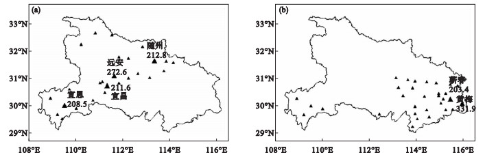
Fig.2
The 500 hPa height field, temperature field, and height field normalized anomaly at 20:00 on June 27, (a) and 20:00 on July 7 (b), the 925 hPa wind and southerly normalized anomaly at 20:00 on June 27 (c) and 20:00 on July 7 (d), and the surface weather chart at 14:00 on June 27 (e) and 08:00 on July 7 (f), 2020"
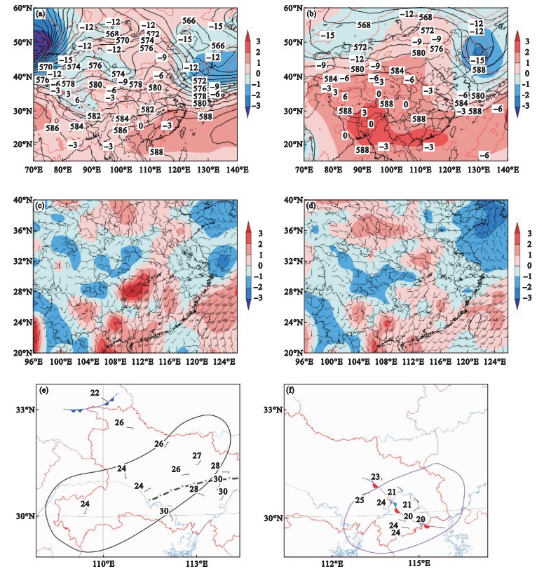
Fig.3
PW and normalized anomaly at 20:00 on June 27 (a) and 20:00 on July 7 (b), 2020, PW and its normalized anomaly sequence diagram at Shuanghe station (c) and Nuobuyuan station (d), and 6 h rainfall and PW normalized anomaly sequence diagram at Shuanghe station (e) and Nuobuyuan station (f)"

Fig.4
CAPE and normalized anomaly at 08:00 on June 27 (a) and July 7 (b), the 850 hPa dew-point temperature and normalized anomaly at 14:00 on June 27 (c) and July 7 (d), and the 850 hPa temperature advection and normalized anomaly at 20:00 on June 27 (e) and July 7 (f), 2020"
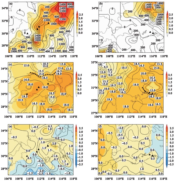
Fig.5
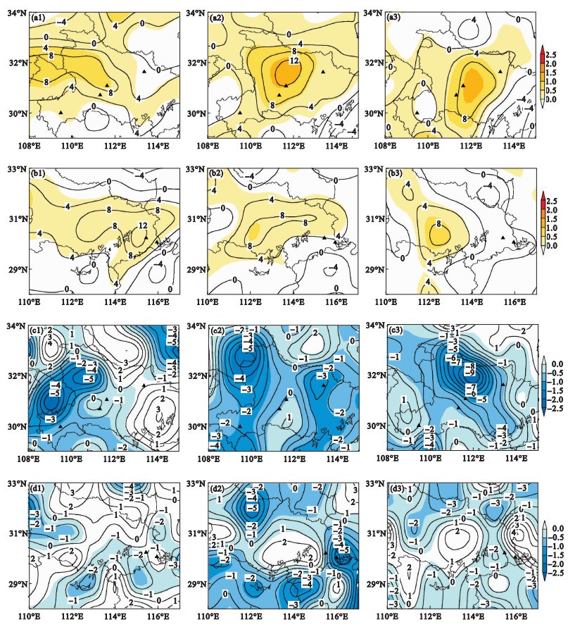
Vorticity and normalized anomaly at 700 hPa (a1), 850 hPa (a2), and 925 hPa (a3) at 20:00 on June 27, at 700 hPa (b1), 850 hPa (b2), 925 hPa (b3) at 20:00 on July 7, and divergence and normalized anomaly at 700 hPa (c1), 850 hPa (c2), and 925 hPa (c3) at 20:00 on June 27, at 700 hPa (d1), 850 hPa (d2), 925 hPa (d3) at 20:00 on July 7, 2020"
| 1 | Stocker T F , Qin D , Plattner G K , et al. Climate change 2013:The physical science basis.Contribution of working group Ⅰto the fifth assessment report of the intergovernmental panel on climate change[M]. Cambridge, United Kingdom and New York, NY, USA: Cambridge University Press, 2013. |
| 2 | 张小莹. 我国极端降水时空特征及风险分析[D]. 上海: 上海师范大学, 2014. |
| 3 | 陈姣, 张耀存. 气候变化背景下陆地极端降水和温度变化区域差异[J]. 高原气象, 2016, 35 (4): 955- 968. |
| 4 |
Wang X L , Hou X Y , Wang Y D . Spatiotemporal variations and regional differences of extreme precipitation events in the Coastal area of China from 1961 to 2014[J]. Atmospheric Research, 2017, 197, 94- 104.
doi: 10.1016/j.atmosres.2017.06.022 |
| 5 |
黄荣辉, 蔡榕硕, 陈际龙, 等. 我国旱涝气候灾害的年代际变化及其与东亚气候系统变化的关系[J]. 大气科学, 2006, 30 (5): 730- 743.
doi: 10.3878/j.issn.1006-9895.2006.05.02 |
| 6 | 陶诗言, 卫捷. 夏季中国南方流域性致洪暴雨与季风涌的关系[J]. 气象, 2007, 33 (3): 10- 18. |
| 7 | 孙凤华, 张耀存, 郭兰丽. 中国东部夏季降水与同期东亚副热带急流位置年代际异常的关系[J]. 高原气象, 2009, 28 (6): 1308- 1315. |
| 8 |
方翀, 毛冬艳, 张小雯, 等. 2012年7月21日北京地区特大暴雨中尺度对流条件和特征初步分析[J]. 气象, 2012, 38 (10): 1278- 1287.
doi: 10.7519/j.issn.1000-0526.2012.10.014 |
| 9 |
张楠, 杨晓君, 何群英, 等. 一次台风残涡引发的天津局地暴雨中尺度对流过程分析[J]. 气象与环境学报, 2020, 36 (4): 1- 10.
doi: 10.3969/j.issn.1673-503X.2020.04.001 |
| 10 | 杨磊, 孙丽, 王东东, 等. 2017年"海棠"台风影响辽宁不同区域极端暴雨成因分析[J]. 气象与环境学报, 2020, 36 (1): 1- 10. |
| 11 |
林璇, 赵磊, 李得勤, 等. 华北"7.20"特大暴雨多尺度特征分析[J]. 气象与环境学报, 2020, 36 (3): 1- 9.
doi: 10.3969/j.issn.1673-503X.2020.03.001 |
| 12 | 杜钧, GrummR H, 邓国. 预报异常极端高影响天气的"集合异常预报法": 以北京2012年7月21日特大暴雨为例[J]. 大气科学, 2014, 38 (4): 685- 699. |
| 13 | 张萍萍, 孙军, 车钦, 等. 2016年湖北梅汛期一次极端强降雨的气象因子异常特征分析[J]. 气象, 2018, 44 (11): 1424- 1433. |
| 14 |
何光碧, 师锐, 曾波. 2018年7月四川盆地降水异常特征及成因分析[J]. 气象与环境学报, 2020, 36 (6): 21- 30.
doi: 10.3969/j.issn.1673-503X.2020.06.003 |
| 15 | 娄小芬, 马昊, 黄旋旋, 等. 台风"利奇马"造成浙江极端降水的成因分析[J]. 气象科学, 2020, 40 (1): 78- 88. |
| 16 | 孙建华, 张小玲, 卫捷, 等. 20世纪90年代华北大暴雨过程特征的分析研究[J]. 气候与环境研究, 2005, 10 (3): 492- 506. |
| 17 | 钱维宏, 蒋宁, 杜钧. 中国东部7类暴雨异常环流型[J]. 气象, 2016, 42 (6): 674- 685. |
| 18 | 张家国, 王珏, 吴涛, 等. 长江中游地区极端降水主要天气系统类型分析[J]. 暴雨灾害, 2018, 37 (1): 14- 23. |
| 19 | 钟敏, 车钦, 张蒙蒙, 等. 华中区域极端降水天气形势及物理量异常度特征[J]. 气象, 2020, 46 (4): 503- 516. |
| 20 | Bonsal B R , Zhang X , Vincent L A , et al. Characteristics of daily and extreme temperatures over Canada[J]. Journal of Climate, 2001, 14 (9): 1959- 1976. |
| 21 | Grumm R H , Hart R . Standardized anomalies applied to significant cold season weather events: preliminary findings[J]. Weather and Forecasting, 2001, 16 (6): 736- 754. |
| 22 | 刘健文, 郭虎, 李耀东, 等. 天气分析预报物理量计算基础[M]. 北京: 气象出版社, 2005: 91- 97. |
| 23 | 刘兵, 戴泽军, 胡振菊, 等. 张家界多个例降雹过程对比分析[J]. 气象, 2009, 35 (7): 23- 32. |
| 24 | 丁一汇. 高等天气学[M]. 北京: 气象出版社, 2005: 315- 336. |
| 25 | 朱乾根, 林锦瑞, 寿绍文, 等. 天气学原理与方法[M]. 北京: 气象出版社, 2007: 393- 398. |
| 26 | 王秀明, 俞小鼎, 周小刚. 中国东北龙卷研究: 环境特征分析[J]. 气象学报, 2015, 73 (3): 425- 441. |
| [1] | Jie MA, Xiao-lin LIU, Hong LI, Sen YANG, Xin-hua LIU, Shan YIN, Hong-chang REN, Yi LIU, Feng ZHANG. Analysis of the forecast error of rainband position in medium-range during a Meiyu heavy rainfall event [J]. Journal of Meteorology and Environment, 2020, 36(4): 11-17. |
| [2] | LIAO Yu-fang, ZHANG Jian-ming. Correlations between rainy season of Hu'nan province and different rainy stages of South China [J]. Journal of Meteorology and Environment, 2018, 34(1): 69-81. |
| [3] | TIAN Li, YAN Qi, LU Jing-long, CHEN Ni-na. The enhancement mechanism analysis of low vortex in a snowstorm over Liaoning province [J]. Journal of Meteorology and Environment, 2017, 33(1): 12-18. |
| [4] | TIAN Xiu-xia,HE Li-hua,CHEN Xiao-juan. Analysis of isentropic potential vorticity for a heavy rain caused by a southwestern low vortex [J]. Journal of Meteorology and Environment, 2014, 30(6): 25-30. |
| [5] | XIN Fei,CHEN Bo-min,SUN Guo-wu. Low-frequency characteristics of heavy rain and its extended forecast during Meiyu season in Shanghai [J]. Journal of Meteorology and Environment, 2014, 30(6): 61-67. |
| [6] | LOU Xiao-fen,LUO Ling,KONG Zhao-lin. Characteristics of Meiyu and its forming reason in the middle and lower reaches of the Yangtze River in 2011 [J]. Journal of Meteorology and Environment, 2014, 30(2): 14-22. |
| [7] | LIU Xi-wen,XU Shuang-zhu, WANG Yan,YANG Hong-long,LI De-qin . Diagnostic analysis of three heavy rainfall processes during Meiyu period in Hubei province [J]. Journal of Meteorology and Environment, 2013, 29(6): 1-7. |
| [8] | ZHANG Xi-ying,XU Yue. Evolution feature of mecoscale convective system (MCS) in a summer low vortex system [J]. Journal of Meteorology and Environment, 2013, 29(2): 1-5. |
| [9] | SU Ji-feng,;ZHOU Tao;ZHU Bin;LIU Shu-yuan. Diagnostic analysis on Meiyu rainstorm and its simulation based on backward trajectory analysis method during June 2009 in the south of Anhui province [J]. Journal of Meteorology and Environment, 2010, 26(3): 34-38. |
| [10] | FENG Li-hua ZHAO Xian-chan MAO Zhang-lin HUA Yun-feng ZHU Yue-juan ZHU Chi-ze ZHANG Xing-cai LUO Gao-yuan . Characteristics of precipitation in Yiwu,Jiangsu province [J]. Journal of Meteorology and Environment, 2008, 24(1): 1-4. |
| Viewed | ||||||
|
Full text |
|
|||||
|
Abstract |
|
|||||
|