| 1 |
孙继松, 戴建华, 何立富, 等.强对流天气预报的基本原理与技术方法[M].北京: 气象出版社,2014:52-58.
|
| 2 |
俞小鼎, 王秀明, 李万莉, 等.雷暴与强对流临近预报[M].北京: 气象出版社,2020:82-85.
|
| 3 |
Kingsmill D E .Convection initiation associated with a sea-breeze front, a gust front, and their collision[J].Nephron,1995,123(10):291-292.
|
| 4 |
王彦, 赵坤, 谢涛.海风锋触发雷暴的临近预警技术研究及应用[M].北京: 气象出版社,2020:60-83.
|
| 5 |
王彦, 李胜山, 郭立, 等.渤海湾海风锋雷达回波特征分析[J].气象,2006,32(12):23-28, 137.
|
| 6 |
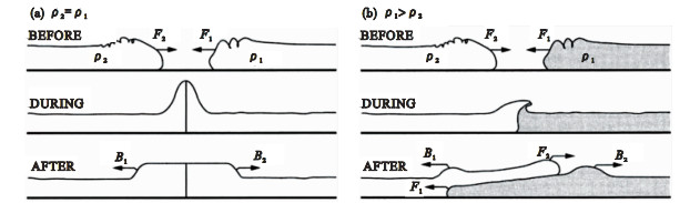
王彦, 于莉莉, 李艳伟, 等.边界层辐合线对强对流系统形成和发展的作用[J].应用气象学报,2011,22(6):724-731.
doi: 10.3969/j.issn.1001-7313.2011.06.010
|
| 7 |
东高红, 何群英, 刘一玮, 等.海风锋在渤海西岸局地暴雨过程中的作用[J].气象,2011,37(9):1100-1107.
|
| 8 |
张晶, 姚文, 陈海涛, 等.渤海北部东岸海风锋活动及其触发对流特征分析[J].气象与环境学报,2021,37(2):33-40.
|
| 9 |
朱乾根, 林锦瑞, 寿绍文, 等.天气学原理和方法[M].北京: 气象出版社,2000:235-238.
|
| 10 |
白华, 袁潮, 潘晓, 等.辽宁省温带气旋龙卷的环境参数特征[J].应用气象学报,2023,34(1):104-116.
|
| 11 |
樊李苗, 俞小鼎.中国短时强对流天气的若干环境参数特征分析[J].高原气象,2013,32(1):156-165.
|
| 12 |
崔胜权, 梁寒, 李爽.辽宁强对流天气物理量阈值探索统计分析[J].气象科技进展,2015,5(5):55-59.
|
| 13 |
Kingsmill D E , Crook N A .An observational study of atmospheric bore formation from colliding density currents[J].Monthly Weather Review,2010,131(12):2985-3002.
|
| 14 |
Doswell C A Ⅲ .Severe convective storms[J].Meteor Monogr,2001,69,1-26.
|
| 15 |
王秀明, 周小刚, 俞小鼎.雷暴大风环境特征及其对风暴结构影响的对比研究[J].气象学报,2013,71(5):839-852.
|
| 16 |
刘彬贤, 王彦, 刘一玮.渤海湾海风锋与阵风锋碰撞形成雷暴天气的诊断特征[J].大气科学学报,2015,38(1):132-136.
|
 ),Kuizhi CAI1,*(