主办单位:中国气象局沈阳大气环境研究所
国际刊号:ISSN 1673-503X
国内刊号:CN 21-1531/P
国际刊号:ISSN 1673-503X
国内刊号:CN 21-1531/P
Journal of Meteorology and Environment ›› 2023, Vol. 39 ›› Issue (5): 9-18.doi: 10.3969/j.issn.1673-503X.2023.05.002
• Articles • Previous Articles Next Articles
Pengyu HU1( ),Shuang XU2,Shibo GENG1,Chuanlei CHEN1,*(),Chang SU3,Shengyuan CHEN4
Received:2023-04-11
Online:2023-10-28
Published:2023-11-28
Contact:
Chuanlei CHEN
E-mail:hu471064185@163.com;ln_ccl@163.com
CLC Number:
Pengyu HU,Shuang XU,Shibo GENG,Chuanlei CHEN,Chang SU,Shengyuan CHEN. Characteristic analysis of thunderstorm gale process in Shenyang under a background of cold vortex[J]. Journal of Meteorology and Environment, 2023, 39(5): 9-18.
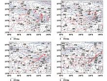
Fig.1
The geopotential height and temperature field at 500 hPa, the wind field at 850 hPa at 14:00 on June 24 (a), at 02:00 (b), 08:00 (c) and 20:00 (d) on June 25, 2022"
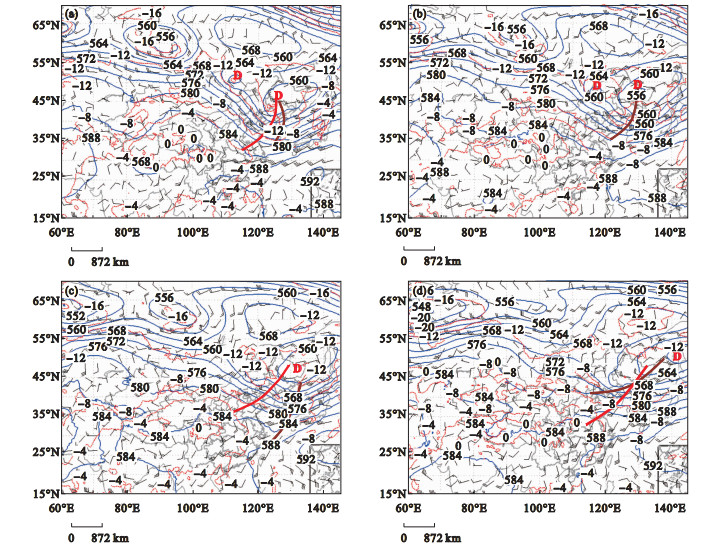
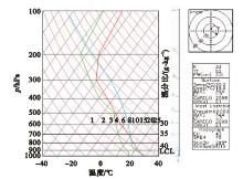
Fig.2
T-lnP diagram of Shenyang station at 14:00 on June 25, 2022"

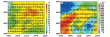
Fig.3
Distribution of K index (a) and CAPE (b) at 16:00 on June 25, 2022 in Liaoning province"
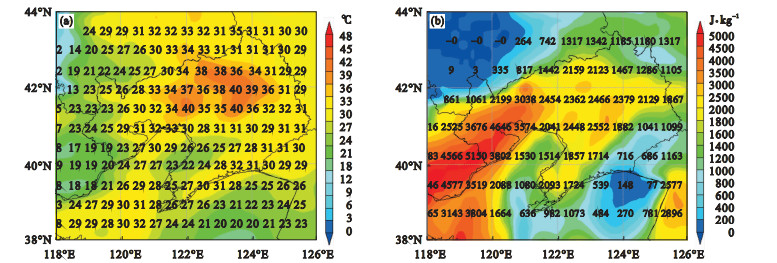
Fig.4
Wind field on 850 hPa at 08:00 (a) and 14:00 (b) on June 25, 2022"
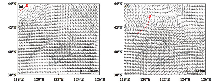
Fig.5
Wind field on 10 m at 14:00 (a) and 17:00 (b) on June 25, 2022"
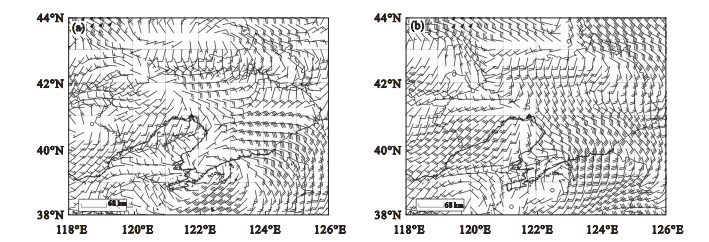
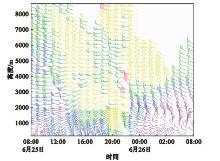
Fig.6
Time height evolution of wind field over Shenyang station from 08:00 on June 25 to 08:00 on June 26, 2022"
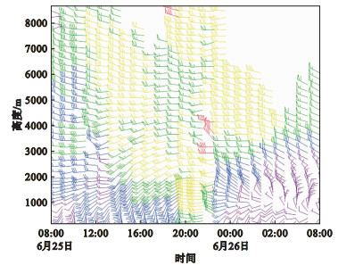
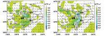
Fig.7
Distribution of dew point temperature advection and wind field at 700 hPa at 16:00 (a) and 17:00 (b) on June 25, 2022"

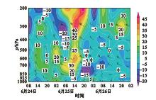
Fig.8
Temperature advection and time height evolution of wind field from 08:00 on June 24 to 08:00 on June 26, 2022"


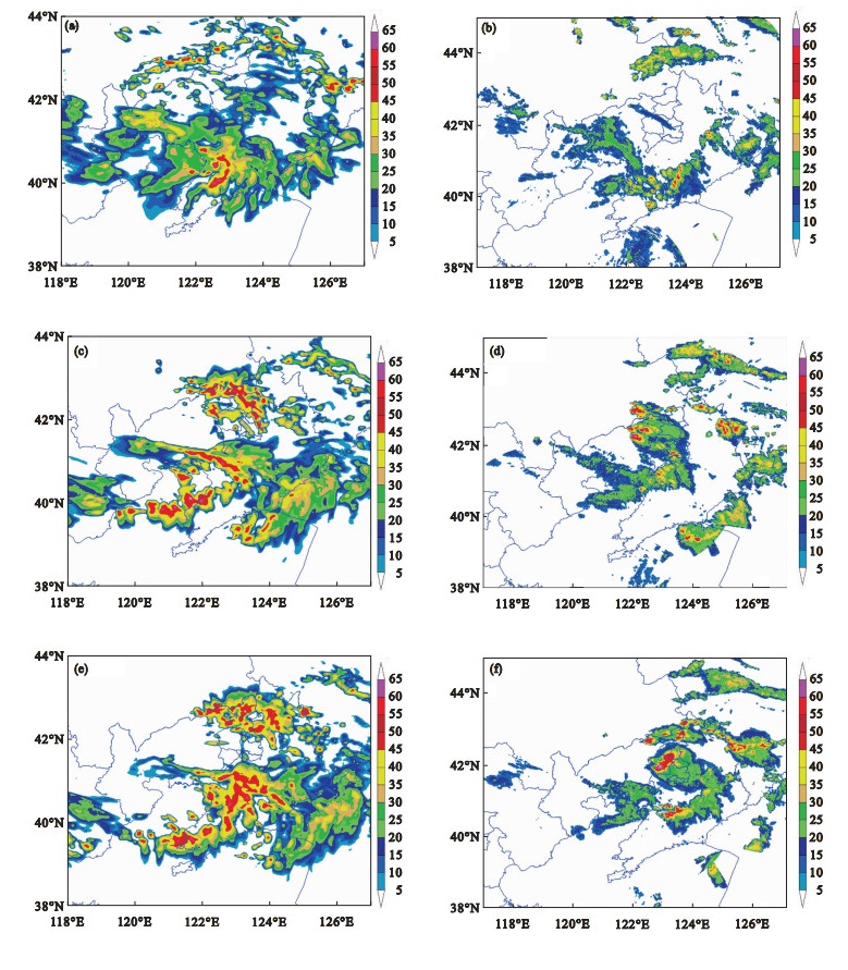
Fig.9
Radar combination reflectivity puzzle in Liaoning province at 17:36 (a), 18:00 (b), 19:48 (c), and 20:54 (d) on June 25, 2022"
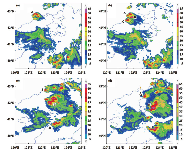

Fig.10
Vertical profile of 0.5° elevation reflectance factor (a), 4.3° elevation relative storm velocity (b), reflectance factor along line AB (c), and relative storm velocity (d) at 20:18 from Shenyang radar on June 25, 2022"
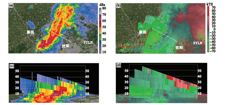
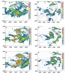
Fig.11
Radar combination reflectance map at 17:00 (a), 19:00 (b), 20:00 (c) forecast by CMA-3km model at 20:00 on June 24 and radar reflectivity profile at 17:00 (d), 19:00 (e) and 20:00 (f) on June 25, 2022"
| 1 |
方翀, 俞小鼎, 朱文剑, 等.2013年3月20日湖南和广东雷暴大风过程的特征分析[J].气象,2015,41(11):1305-1314.
doi: 10.7519/j.issn.1000-0526.2015.11.001 |
| 2 | 苏爱芳, 梁俊平, 崔丽曼, 等.豫北一次局地雹暴天气的预警特征和触发机制[J].气象与环境学报,2012,28(6):1-7. |
| 3 | 李昱茜, 杨景泰, 隋玉秀, 等.大连地区阵风系数特征分析[J].气象与环境学报,2022,38(5):98-105. |
| 4 |
刘艳杰, 王清川, 许敏, 等.2019年5月北京一次强降水超级单体特征及成因分析[J].气象与环境学报,2021,37(4):9-17.
doi: 10.3969/j.issn.1673-503X.2021.04.002 |
| 5 |
崔丽曼, 苏爱芳, 张宇星, 等.2016年河南省一次大范围强对流天气成因分析[J].气象与环境学报,2020,36(2):9-19.
doi: 10.3969/j.issn.1673-503X.2020.02.002 |
| 6 |
杨晓亮, 杨敏.2017年秋季河北一次飑线引发的雷暴大风过程分析[J].气象与环境学报,2020,36(6):1-9.
doi: 10.3969/j.issn.1673-503X.2020.06.001 |
| 7 | 廖晓农, 于波, 卢丽华.北京雷暴大风气候特征及短时临近预报方法[J].气象,2009,35(9):18-28. |
| 8 | 方翀, 王西贵, 盛杰, 等.华北地区雷暴大风的时空分布及物理量统计特征分析[J].高原气象,2017,36(5):1368-1385. |
| 9 | 俞小鼎, 姚秀萍, 熊廷南, 等.多普勒天气雷达原理与业务应用[M].北京: 气象出版社,2006:122-123, 169. |
| 10 | 彭霞云, 章丽娜, 刘汉华, 等.冷涡底部对流引起的杭州湾极端大风形成机制分析[J].气象,2022,48(6):719-728. |
| 11 |
仇娟娟, 何立富.苏沪浙地区短时强降水与冰雹天气分布及物理量特征对比分析[J].气象,2013,39(5):577-584.
doi: 10.3969/j.issn.1674-7097.2013.05.008 |
| 12 | 樊李苗, 俞小鼎.中国短时强对流天气的若干环境参数特征分析[J].高原气象,2013,32(1):156-165. |
| 13 | Kenneth P. Forecasting convective downburst potential over the United States great plains[EB/OL]. (2005-11-29). https://arxiv.org/abs/physics/0511245v1. |
| 14 |
吴迎旭, 周一, 刘松涛, 等.一次引发黑龙江省大风与强降水的β中尺度系统物理机制与特征分析[J].气象与环境学报,2016,32(3):1-9.
doi: 10.3969/j.issn.1673-503X.2016.03.001 |
| 15 | 梁维亮, 屈梅芳, 赖珍权, 等.广西地区一次强雷暴天气过程雷达特征及环境场分析[J].气象与环境学报,2016,32(3):10-18. |
| 16 | 王珏, 肖艳姣, 冷亮, 等.2021年5月武汉两次对流性大风天气的多普勒雷达观测分析[J].暴雨灾害,2022,41(2):119-129. |
| 17 | 郑媛媛, 俞小鼎, 方翀, 等.一次典型超级单体风暴的多普勒天气雷达观测分析[J].气象学报,2004,62(3):317-328. |
| 18 | 陈晓欣, 俞小鼎, 王秀明.中国大范围雷暴大风事件(Derechos)研究: 时空分布、环境背景和对流系统形态特征[J].气象学报,2022,80(1):67-81. |
| 19 | 吴芳芳, 王慧, 韦莹莹, 等.一次强雷暴阵风锋和下击暴流的多普勒雷达特征[J].气象,2009,35(1):55-64. |
| 20 | 李胜山, 张殿江, 胡玲, 等.一次下击暴流显著弓形回波特征[J].气象与环境学报,2012,28(4):84-89. |
| 21 | 涂小萍, 姚日升, 漆梁波, 等.浙江省北部一次灾害性大风多普勒雷达和边界层特征分析[J].高原气象,2014,33(6):1687-1696. |
| 22 | 公衍铎, 郑永光, 罗琪.冷涡底部一次弓状强飑线的演变和机理[J].气象,2019,45(4):483-495. |
| 23 | Kessinger C J , Parsons D B , Wilson J W .Observations of a storm containing misocyclones, downbursts, and horizontal vortex circulations[J].Monthly Weather Review,1988,116(10):1959-1982. |
| 24 | 吴翠红, 韦惠红, 牛奔.湖北东部雷暴大风雷达回波特征分析[J].大气科学学报,2012,35(1):64-72. |
| 25 | 刘希文, 李得勤, 韦惠红, 等.2013年湖北地区两次雷暴大风过程环境及雷达回波特征[J].气象与环境学报,2018,34(1):1-10. |
| 26 | 俞小鼎, 张爱民, 郑媛媛, 等.一次系列下击暴流事件的多普勒天气雷达分析[J].应用气象学报,2006,17(4):385-393. |
| 27 | Atkins N T , Laurent M S .Bow echo mesovortices.Part Ⅱ: their genesis[J].Monthly Weather Review,2009,137(5):1514-1532. |
| 28 | 才奎志. 冷涡背景下辽宁省不同类型雷暴大风对比分析研究[D]. 沈阳: 沈阳农业大学, 2020: 1-54. |
| 29 | 陈传雷, 吴晓峰, 孙晓巍, 等.辽宁省强对流性天气的气候特征分析[J].气象与环境学报,2010,26(3):27-33. |
| 30 | 杨磊, 郑永光, 袁子鹏, 等.2019年8月16日沈阳极端降水事件的低空γ中尺度涡旋观测特征和机理分析[J].气象学报,2023,81(1):19-39. |
| 31 | 郜凌云, 王波.沈阳新一代天气雷达原始数据的生成与解析[J].辽宁气象,2004,20(3):43-44. |
| 32 | 郜凌云.沈阳新一代天气雷达数据传输方式的技术探讨[J].辽宁气象,2003,19(4):29. |
| 33 | 樊李苗, 俞小鼎.杭州地区夏季午后雷暴大风环境条件分析[J].气象,2020,46(12):1621-1632. |
| 34 | 尉英华, 花家嘉, 王莹, 等.近11年天津冰雹统计特征及对流参数指标分析[J].气象,2023,49(2):213-223. |
| 35 | 田付友, 张小玲, 曹艳察, 等.中国中低海拔地区三类强对流天气环境条件的基本气候特征[J].高原气象,2022,41(6):1446-1459. |
| 36 | 费海燕, 王秀明, 周小刚, 等.中国强雷暴大风的气候特征和环境参数分析[J].气象,2016,42(12):1513-1521. |
| 37 | 许长义, 章丽娜, 肖现, 等.冷涡背景下华北平原一次弓形回波致灾大风过程分析[J].气象学报,2023,81(1):40-57. |
| [1] | Songtao LIU, Mengzhu GAO, Duo QI, Chengwei WANG. Research on classification forecast method of severe convective weather in Heilongjiang province based on CMA-MESO [J]. Journal of Meteorology and Environment, 2023, 39(4): 38-46. |
| [2] | Shiteng CAO, Lei YANG, Yu CHEN, Li SUN, Yuxuan LENG, Chao JIANG, Xue YANG. Characteristics of spatio-temporal distribution and environmental parameters of Cold Vortex thunderstorm gales in Liaoning province from 2017 to 2021 [J]. Journal of Meteorology and Environment, 2023, 39(4): 65-73. |
| [3] | Yu CHEN, Shi-teng CAO, Chuan-lei CHEN, Ying WANG, Yei YANG, Chao YUAN, Xue YANG, Chao JIANG, Qi-lin ZHANG, Man-li WU. Analysis of the formation and evolution of super tornado occurred in Kaiyuan of Liaoning province on July 3, 2019 [J]. Journal of Meteorology and Environment, 2023, 39(2): 11-19. |
| [4] | Li REN, Chen LUAN, Xiao-xue WANG, Yue ZHANG. Causes and characteristics of a persistent rainstorm event in warm front of a cold vortex [J]. Journal of Meteorology and Environment, 2022, 38(3): 37-44. |
| [5] | Qi YAN, Shuang LI, Jing-long LU, Fang-da TENG. Characteristics of the continuous cold vortex over Northeast China from 1979 to 2019 [J]. Journal of Meteorology and Environment, 2022, 38(2): 40-45. |
| [6] | Xu ZHANG,Bao-li SUN,Jia-ning BAI,Dan-mei ZHANG,Ke SUN,Xiao-tong YANG,Zhen-yu ZHAO,Xi-long NING. Evaluation of multi-model precipitation forecast of Northeast Cold Vortex in Fuxin [J]. Journal of Meteorology and Environment, 2021, 37(3): 19-24. |
| [7] | Xiao-liang YANG,Min YANG. Analysis of a thunderstorm gale triggered by squall line in autumn of 2017 over central Hebei province [J]. Journal of Meteorology and Environment, 2020, 36(6): 1-09. |
| [8] | Li-man CUI, Ai-fang SU, Yu-xing ZHANG, Chun-xiao WANG, Di WANG. Causes analysis of the formation of an extensive severe convective weather in 2016 in He'nan province [J]. Journal of Meteorology and Environment, 2020, 36(2): 9-19. |
| [9] | XU Lu-lu, LI Qian, LI Hui-lin, HAN Mei, LUO Jian-yu, MENG Xin. Multi-scale comparative analysis of two hail events in Dandong in September 2018 [J]. Journal of Meteorology and Environment, 2019, 35(6): 1-7. |
| [10] | LIU Xi-wen, LI De-qin, WEI Hui-hong, XU Shuang-zhu, GOU A-ning. Environmental and radar echoes characteristic analysis of two thunderstorm gale processes in Hubei province in 2013 [J]. Journal of Meteorology and Environment, 2018, 34(1): 1-10. |
| [11] | LI Ji, JIAO Min, HU Chun-li, LI Fei, ZHANG Xiao-yue, ZHANG Qi, WANG Ying, ZHU Xin-yu. Characteristics of summer temperature and its impact factors in Northeast China from 1951 to 2012 [J]. Journal of Meteorology and Environment, 2016, 32(5): 74-83. |
| [12] | LIANG Wei-liang, QU Mei-fang, LAI Zhen-quan, NONG Meng-song. Analysis of radar features and environmental background during a severe thunderstorm in early summer 2014 in Guangxi Zhuang Autonomous Region [J]. Journal of Meteorology and Environment, 2016, 32(3): 10-18. |
| [13] | XU Hong, CHAO Hua, WANG Wen, CHEN Jun-qing. Statistic and diagnosis of storm rainfall areas based on the Northeast Cold Vortex cases [J]. Journal of Meteorology and Environment, 2016, 32(3): 41-46. |
| [14] | LIU Jing, REN Chuan, DONG Wei, CAI Kui-zhi, CUI Sheng-quan, WANG Ying, CHEN Ni-na. Diagnostic analysis of a strong precipitation in Liaoning province [J]. Journal of Meteorology and Environment, 2016, 32(2): 18-27. |
| [15] | SUN Hong-yu. Relationship of northeast cold vortex with migration and landing of Loxostege sticticalis (Ls) [J]. Journal of Meteorology and Environment, 2014, 30(6): 85-91. |
| Viewed | ||||||
|
Full text |
|
|||||
|
Abstract |
|
|||||
|