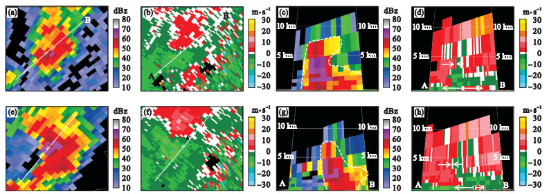
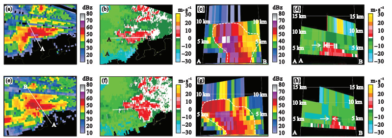
| 1 |
Fujita T T , Byers H R . Spearhead echo and downburst in the crash of an airliner[J]. Monthly Weather Review, 1977, 105 (2): 129- 146.
doi: 10.1175/1520-0493(1977)105<0129:SEADIT>2.0.CO;2
|
| 2 |
Fujita T T . Tornadoes and downbursts in the context of generalized planetary scales[J]. Journal of the Atmospheric Sciences, 1981, 38 (8): 1511- 1534.
doi: 10.1175/1520-0469(1981)038<1511:TADITC>2.0.CO;2
|
| 3 |
Wilson J W , Roberts R D , Kessinger C , et al. Microburst wind structure and evaluation of Doppler radar for airport wind shear detection[J]. Journal of Applied Meteorology and Climate, 1984, 23 (6): 898- 915.
doi: 10.1175/1520-0450(1984)023<0898:MWSAEO>2.0.CO;2
|
| 4 |
王秀明, 俞小鼎, 费海燕, 等. 下击暴流形成机理及监测预警研究进展[J]. 气象, 2023, 49 (2): 129- 145.
|
| 5 |
杨波, 孙继松, 刘鑫华. 两类不同风灾个例超级单体特征对比分析[J]. 气象学报, 2019, 77 (3): 427- 441.
|
| 6 |
盛杰, 郑永光, 沈新勇, 等. 2018年一次罕见早春飑线大风过程演变和机理分析[J]. 气象, 2019, 45 (2): 141- 154.
|
| 7 |
Hjelmfelt M R . Structure and life cycle of microburst outflows observed in Colorado[J]. Journal of Applied Meteorology and Climatology, 1988, 27 (8): 900- 927.
doi: 10.1175/1520-0450(1988)027<0900:SALCOM>2.0.CO;2
|
| 8 |
康岚, 刘炜桦, 肖递祥, 等. 四川盆地一次极端大风天气过程成因及预报着眼点分析[J]. 气象, 2018, 44 (11): 1414- 1423.
|
| 9 |
王易, 郑媛媛, 庄潇然, 等. 江苏典型下击暴流风暴结构特征统计分析[J]. 气象学报, 2022, 80 (4): 592- 603.
|
| 10 |
Pryor K L . Progress and developments of downburst prediction applications of GOES[J]. Weather and Forecasting, 2015, 30 (5): 1182- 1200.
doi: 10.1175/WAF-D-14-00106.1
|
| 11 |
肖艳姣, 王珏, 王志斌, 等. 基于S波段新一代天气雷达观测的下击暴流临近预报方法[J]. 气象, 2021, 47 (8): 919- 931.
|
| 12 |
毕旭, 罗慧, 刘勇. 陕西中部一次下击暴流的多普勒雷达回波特征[J]. 气象, 2007, 33 (1): 70-73, 插3, 插4.
|
| 13 |
吴芳芳, 王慧, 韦莹莹, 等. 一次强雷暴阵风锋和下击暴流的多普勒雷达特征[J]. 气象, 2009, 35 (1): 55-64, 后插4-后插7.
|
| 14 |
刁秀广, 赵振东, 高慧君, 等. 三次下击暴流雷达回波特征分析[J]. 气象, 2011, 37 (5): 522- 531.
doi: 10.3969/j.issn.1671-1742.2011.05.009
|
| 15 |
王俊, 龚佃利, 刁秀广, 等. 一次弓状回波、强对流风暴及合并过程研究Ⅰ: 以单多普勒雷达资料为主的综合分析[J]. 高原气象, 2011, 30 (4): 1067- 1077.
|
| 16 |
张怡, 赵志宇. 豫东地区"6.3"与"7.17"两次致灾大风雷达资料对比分析[J]. 高原气象, 2012, 31 (2): 515- 529.
|
| 17 |
李彩玲, 蔡康龙, 黄先香, 等. 桂林一次强下击暴流成因分析[J]. 气象, 2021, 47 (2): 242- 252.
|
| 18 |
俞小鼎, 张爱民, 郑媛媛, 等. 一次系列下击暴流事件的多普勒天气雷达分析[J]. 应用气象学报, 2006, 17 (4): 385- 393.
doi: 10.3969/j.issn.1001-7313.2006.04.001
|
| 19 |
王秀明, 俞小鼎, 周小刚, 等. "6.3"区域致灾雷暴大风形成及维持原因分析[J]. 高原气象, 2012, 31 (2): 504- 514.
|
| 20 |
俞小鼎, 郑永光. 中国当代强对流天气研究与业务进展[J]. 气象学报, 2020, 78 (3): 391- 418.
|
| 21 |
胡鹏宇, 徐爽, 耿世波, 等. 一次冷涡背景下沈阳地区雷暴大风过程的特征分析[J]. 气象与环境学报, 2023, 39 (5): 9- 18.
|
| 22 |
左涛, 王科, 孙晓磊, 等. 2018—2021年渤海中西部海域雷暴大风时空分布特征[J]. 气象与环境学报, 2024, 40 (2): 86- 95.
|
| 23 |
王丽娟, 江燕如, 唐卫亚, 等. 临近和短时天气预报教程[M]. 北京: 气象出版社, 2017: 50- 55.
|
| 24 |
廖晓农, 于波, 卢丽华. 北京雷暴大风气候特征及短时临近预报方法[J]. 气象, 2009, 35 (9): 18-28, 后插2.
|
| 25 |
Markowski P , Richardson Y . Mesoscale Meteorology in Midlatitudes[M]. Hoboken, New Jersey: Wiley Blackwell, 2010: 430.
|
| 26 |
Kessinger C J , Parsons D B , Wilson J W . Observations of a storm containing misocyclones, downbursts, and horizontal vortex circulations[J]. Monthly Weather Review, 1988, 116 (10): 1959- 1982.
|
| 27 |
周后福, 刁秀广, 赵倩, 等. 一次连续下击暴流天气的成因分析[J]. 干旱气象, 2017, 35 (4): 641- 648.
|
| 28 |
Clark T L , List R . Dynamics of a falling particle zone[J]. Journal of the Atmospheric Sciences, 1971, 28 (5): 718- 727.
|
| 29 |
Adachi T , Kusunoki K , Yoshida S , et al. High-speed volumetric observation of a wet microburst using X-band phased array weather radar in Japan[J]. Monthly Weather Review, 2016, 144 (10): 3749- 3765.
|
 ),Yongming JI4,Yunxia DUAN5,Xiaochu LIU3,Jun LIANG3,*(