主办单位:中国气象局沈阳大气环境研究所
国际刊号:ISSN 1673-503X
国内刊号:CN 21-1531/P

气象与环境学报 ›› 2021, Vol. 37 ›› Issue (4): 1-8.doi: 10.3969/j.issn.1673-503X.2021.04.001

• 论文 • 上一篇    下一篇

一次东北冷涡云降水垂直结构特征分析

张晋广(),赵姝慧*(),刘旸,孙丽,单楠,张铁凝,张梦佳   

  1. 辽宁省人工影响天气办公室, 辽宁 沈阳 110166
  • 收稿日期:2021-05-20 出版日期:2021-08-30 发布日期:2021-09-10
  • 通讯作者: 赵姝慧 E-mail:lnzjg@126.com;zhaoshuhui512@163.com
  • 作者简介:张晋广, 男, 1963年生, 高级工程师, 主要从事人工影响天气方面研究, E-mail: lnzjg@126.com
  • 基金资助:
    辽宁省科学技术计划项目农业攻关及产业化指导计划(2019JH2/10200019);国家重点研发计划(2018YFC1507900);辽宁省自然基金指导计划项目(2019-ZD-0856)

Observations and analysis of vertical structure of cloud and precipitation caused by a cold vortex in Northeast China

Jin-guang ZHANG(),Shu-hui ZHAO*(),Yang LIU,Li SUN,Nan SHAN,Tie-ning ZHANG,Meng-jia ZHANG   

  1. Liaoning Weather Modification Center, Shenyang 110166, China
  • Received:2021-05-20 Online:2021-08-30 Published:2021-09-10
  • Contact: Shu-hui ZHAO E-mail:lnzjg@126.com;zhaoshuhui512@163.com

摘要:

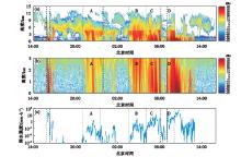
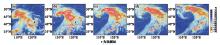
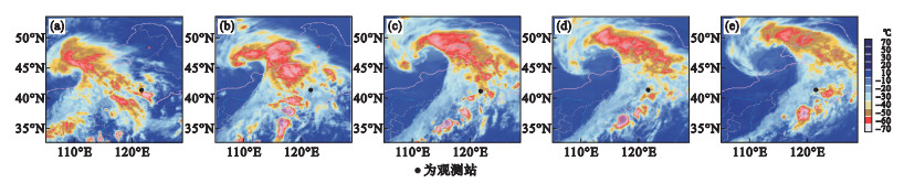
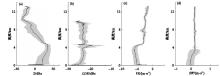
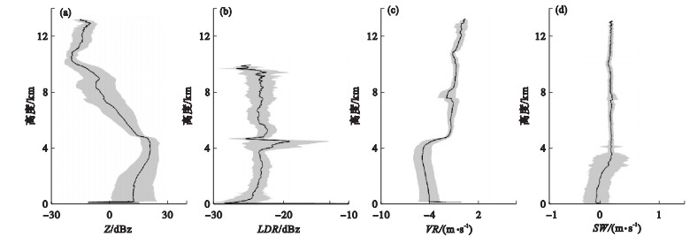
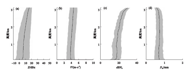
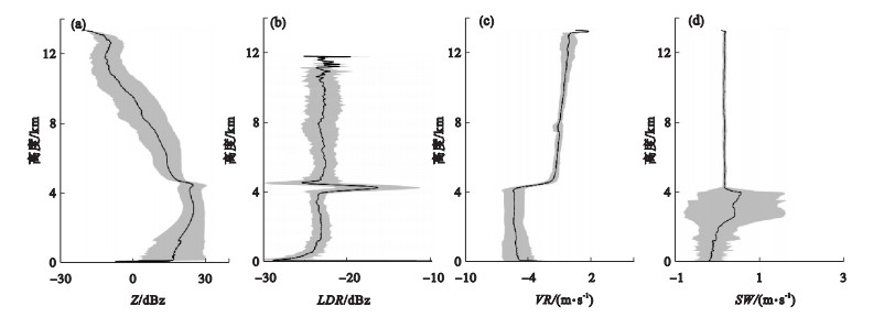
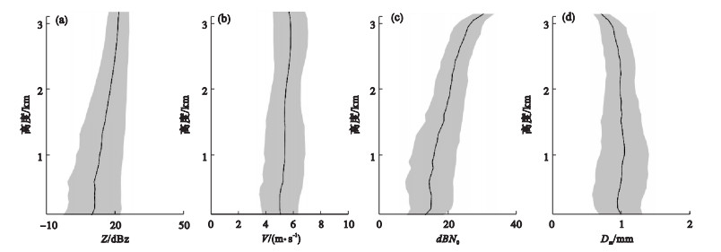
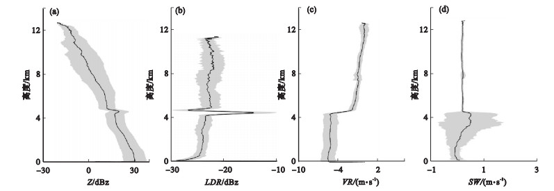
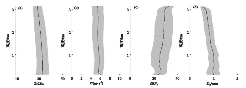
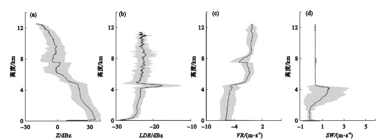
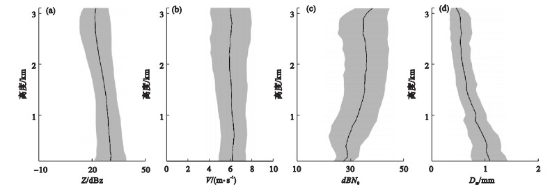
利用辽宁阜新国家站(121.7458°E,42.0672°N)的毫米波云雷达(8 mm)和微雨雷达(12.5 mm)对2020年8月12-13日东北冷涡影响下的一次降水过程进行了观测,分析了云降水的垂直结构特征并探讨了降水机制。结果表明:本次过程中,云水平方向发展不均匀,以层状云和层积混合云为主,云内有时还嵌有对流泡。云降水阶段性变化明显,先后出现了层状云降水、层积混合云降水和对流云降水。层状云降水和层积混合云降水均表现出明显的亮带特征,但层积混合云降水的雷达回波强度、回波顶高和降水强度明显大于层状云降水。对流云降水的雷达回波会因强降水而产生明显衰减,因此回波顶高不能表示出实际的云顶情况。层状云降水阶段,云雷达反射率随高度降低增长缓慢,雨滴在下落过程中受蒸发和碰并的共同作用,反射率降低。与层状云降水相比,层积混合云降水的碰并效应强,且由于前期降水对近地面的增湿作用,使云下蒸发弱。对流云降水阶段,反射率的增长主要发生在冰水混合层,有利于大滴的产生,拓宽了云滴谱,提高了碰并效率。

关键词: 东北冷涡, 云降水垂直结构, 毫米波云雷达, 微雨雷达

Abstract:

Based on the data observed from a millimeter wavelength cloud radar (8 mm) and a micro rain radar (12.5 mm) at Fuxin national weather station (121.7458°E, 42.0672°N) in Liaoning province during a precipitation event caused by a cold vortex in Northeast China on August 12-13, 2020, we analyzed the characteristics of vertical structures of cloud and precipitation and discussed the precipitation mechanism. The results indicated that clouds develop unevenly in the horizontal direction during the precipitation, dominated by stratiform clouds and stratocumulus mixed clouds, and sometimes convective bubbles are embedded in the clouds. The cloud precipitation has changed significantly in stages, with stratiform cloud precipitation, stratocumulus mixed cloud precipitation, and convective cloud precipitation successively occurring. Both stratiform cloud precipitation and stratocumulus mixed cloud precipitation exhibit obvious bright bands, and the radar echo intensity, echo top height, and precipitation intensity of the stratiform mixed cloud precipitation are greater than that of the stratiform cloud precipitation. The radar echo of convective cloud precipitation attenuates obviously due to the heavy precipitation, thus the echo top height cannot indicate the actual cloud top situation. During the precipitation stage of stratiform clouds, the cloud radar reflectivity increases slowly as the altitude decreases, and the reflectivity decreases due to the combined effects of evaporation and collision of raindrops during their falling process. Compared with the precipitation in the stratiform cloud, the colliding effect of stratocumulus mixed cloud precipitation is stronger, and the evaporation under the cloud becomes weak due to the near-surface humidification effect of the previous precipitation. During the stage of convective cloud precipitation, the increase in reflectivity mainly occurs in the ice-water mixed layer, which favors generating large droplets, broadens the cloud drop spectrum, and improves the efficiency of collision.

Key words: Northeast China cold vortex, Vertical structure of cloud and precipitation, Millimeter wavelength cloud radar, Micro rain radar

中图分类号: