主办单位:中国气象局沈阳大气环境研究所
国际刊号:ISSN 1673-503X
国内刊号:CN 21-1531/P

气象与环境学报 ›› 2021, Vol. 37 ›› Issue (6): 93-99.doi: 10.3969/j.issn.1673-503X.2021.06.012

• 论文 • 上一篇    下一篇

辽宁省典型地形测风塔缺测数据线性计算适用性分析

顾正强1(),龚强1,*(),沈历都1,徐红1,马东雷2,朱玲1,晁华1,冯冬蕾3   

  1. 1. 沈阳区域气候中心, 辽宁 沈阳, 110166
    2. 辽宁省气象服务中心, 辽宁 沈阳, 110166
    3. 沈阳中心气象台, 辽宁 沈阳, 110166
  • 收稿日期:2020-09-07 出版日期:2021-12-30 发布日期:2021-12-09
  • 通讯作者: 龚强 E-mail:393558873@qq.com;isgq@sina.com
  • 作者简介:顾正强, 男, 1984年生, 高级工程师, 主要从事气候资源开发利用和气候可行性论证方面的研究, E-mail: 393558873@qq.com
  • 基金资助:
    2019年辽宁省气象局科学技术研究项目(BA201901);辽宁省博士科研启动基金计划项目(2020-BS-276)

Applicability analysis of linear calculation for missing data of wind tower on typical terrain in Liaoning province

Zheng-qiang GU1(),Qiang GONG1,*(),Li-du SHEN1,Hong XU1,Dong-lei MA2,Ling ZHU1,Hua CHAO1,Dong-lei FENG3   

  1. 1. Regional Climate Center of Shenyang, Shenyang 110166, China
    2. Liaoning Provincial Meteorological Service Center, Shenyang 110166, China
    3. Shenyang Central Meteorological Observatory, Shenyang 110166, China
  • Received:2020-09-07 Online:2021-12-30 Published:2021-12-09
  • Contact: Qiang GONG E-mail:393558873@qq.com;isgq@sina.com

摘要:

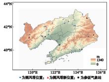
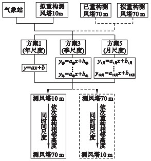
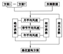
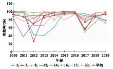
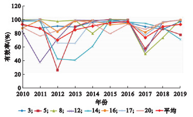
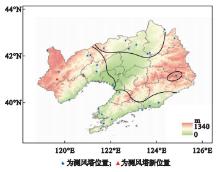
利用辽宁省典型地形26座测风塔和6个同期气象站的逐时风速实测数据,采用不同时间尺度(月、季、年)的线性拟合并结合风切变指数拟定7个方案重构测风塔缺测风速数据,并对各拟定重构方案进行误差检验。结果表明:辽宁省典型地形测风塔缺测数据重构主要以季节尺度的线性拟合及其结合风切变指数的两个方案(方案3和方案7)为最优方案,且上述两个方案的空间分布具有区域性特征,其中,辽宁北部的平原和丘陵、辽宁东南部的沿海平原和沿海丘陵主要以方案7为最优方案,辽宁西部的丘陵和山地主要以方案3为最优方案,个别地区以方案1或方案4为最优方案。温带大陆性季风气候区所具有的季节性风速变化和固有的地形地势特征及其对风切变指数的影响,是辽宁省典型地形测风塔缺测数据重构最优方案空间分布呈区域性特征的主要成因。

关键词: 数据重构, 线性拟合, 风切变指数, 最优方案

Abstract:

Using the hourly measured wind speed data from 26 wind towers and 6 weather stations at the same period in Liaoning province, the linear fitting at different time scales (month, season, and year), together with wind sheer index, were used to develop 7 schemes to reconstruct the missing wind speed data of the wind towers, and the error test of each proposed reconstruction scheme was conducted.Results show that the linear fitting on monthly data, with corresponding wind sheer indexes (schemes 3 and 7), is the optimal scheme for the data reconstruction of wind towers on typical terrain in Liaoning province.And the spatial distribution of the above two schemes has regional characteristics.Among them, scheme 7 works for the towers on plains and hills in northern Liaoning province and also for towers on coastal plains and hills in southeastern Liaoning province.Scheme 3 is chosen for those on hills and mountains in western Liaoning province, schemes 1 and 4 are only applicable to the towers on the remaining areas.The seasonal wind speed variation and inherent topographical characteristics in temperate continental monsoon climate zone and their influence on wind shear index are the main causes of the spatial distribution characteristics of the optimal scheme for the reconstruction of missing data of wind towers on typical terrain in Liaoning province.

Key words: Data reconstruction, Linear fitting, Wind shear index, Optimal scheme

中图分类号: