主办单位:中国气象局沈阳大气环境研究所
国际刊号:ISSN 1673-503X
国内刊号:CN 21-1531/P

气象与环境学报 ›› 2022, Vol. 38 ›› Issue (1): 1-7.doi: 10.3969/j.issn.1673-503X.2022.01.001

• 论文 • 上一篇    下一篇

冬奥会张家口赛区一次降水相态特征分析

马梁臣1,2(),马洪波1,张曦丹3,陈子健4,李江波4   

  1. 1. 吉林省气象台, 吉林 长春 130062
    2. 东北冷涡研究开放重点实验室, 辽宁 沈阳 110166
    3. 张家口市气象局, 河北 张家口 075000
    4. 河北省气象台, 河北 石家庄 050021
  • 收稿日期:2021-02-02 出版日期:2022-02-28 发布日期:2022-03-02
  • 作者简介:马梁臣, 男, 1986年生, 高级工程师, 主要从事天气预报与大气物理与环境研究, E-mail: liangchenma@163.com
  • 基金资助:
    科技部冬奥科技专项(2018YFF0300104);科技部冬奥科技专项(2018YFF0300101);中国气象局预报员专项(CMAYBY2020-034)

Analysis of phase characteristics of a precipitation process in Zhangjiakou area of Winter Olympic Games

Liang-chen MA1,2(),Hong-bo MA1,Xi-dan ZHANG3,Zi-jian CHEN4,Jiang-bo LI4   

  1. 1. Jilin Meteorological Observatory, Changchun 130062, China
    2. Key Opening Laboratory for Northeast China Cold Vortex Research, Shenyang 110166, China
    3. Zhangjiakou Meteorological Service, Zhangjiakou 075000, China
    4. Hebei Meteorological Observatory, Shijiazhuang 050021, China
  • Received:2021-02-02 Online:2022-02-28 Published:2022-03-02

摘要:

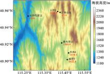
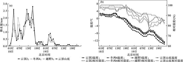
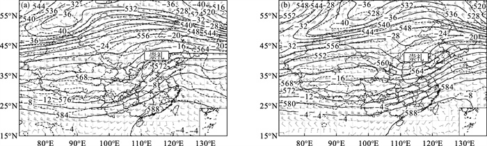
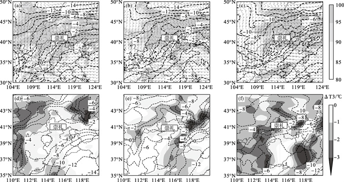
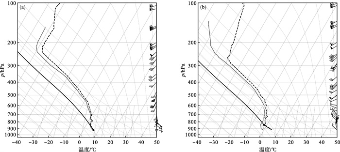
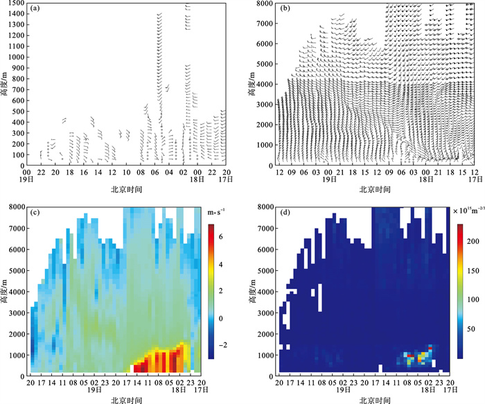
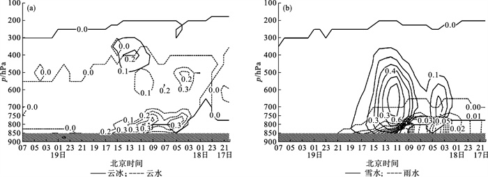
利用冬奥会气象观测站网资料、ERA5的0.25°×0.25°高分辨率再分析资料、常规探空资料以及激光雷达和风廓线雷达资料,从环流形势、温湿度和微物理特征以及雷达特征等方面对2020年11月17-19日冬奥会张家口赛区一次明显的雨转雪天气过程进行分析。结果表明:低层前期的暖湿西南气流,为降水提供好的水汽和能量条件,后期强的干冷平流为相态转换提供有利条件。赛区出现雨转雪时,700 hPa温度低于-2℃,同时850 hPa温度低于2℃。零度层高度的快速下降是相态转换的重要温度判据,0℃线降到距地面400 m左右赛区降水相态已经转变为纯雪,低层风向的转向对赛场的雨雪相态转换有一定的指示意义。随着高空云冰和雪水含量逐渐增加,其出现最大值后,雨雪相态开始转换。降雪时激光雷达最大探测高度比降雨时有明显的降低,风廓线雷达低层风场的变化和雨雪相态关系密切,风廓线雷达探测的垂直速度变化也能反映雨雪相态的转换。

关键词: 冬奥会, 雨雪相态, 温湿度, 风廓线雷达

Abstract:

Based on the meteorological observation network data of the Winter Olympics Games, the high-resolution reanalysis data of ERA5 (ECMWF Reanalysis v5) (0.25°×0.25°), the conventional sounding data, and the laser radar and wind profile radar data, a rain-to-snow weather process in Zhangjiakou area of the Winter Olympics Games from November 17-19, 2020 was analyzed.The variables analyzed include the circulation situation, temperature and relative humidity, microphysical and radar characteristics, and other new data.The results show that the warm and wet southwest airflow in the early stage of the low layer provides water vapor and energy conditions for precipitation, and the strong dry and cold advection in the later stage provides favorable conditions for phase transition.When rain turns to snow in the competition area, the temperature at 700 hPa is below -2℃, while the temperature at 850 hPa is below 2℃.The rapid decline of the height of zero-temperature level is an important temperature criterion for phase transition.When the 0℃ line drops to about 400 m above the ground, the phase of precipitation in the competition area has turned into pure snow, and the shift of the wind direction at a low level has certain indicative significance for the phase transition of rain and snow in the competition area.As the content of cloud ice and snow water increases gradually, the phase of rain and snow begins to change after the cloud ice and snow water reach the maximum.The maximum detection height of lidar during snowfall is significantly lower than that during rainfall.The change of low-level wind field of wind profiler radar is closely related to the phase state of rain and snow, and the change of vertical velocity detected by wind profiler radar can also reflect the transformation of rain and snow phase state.

Key words: Winter Olympic Games, Rain and snow phase, Temperature and relative humidity, Wind profile radar

中图分类号: