主办单位:中国气象局沈阳大气环境研究所
国际刊号:ISSN 1673-503X
国内刊号:CN 21-1531/P
国际刊号:ISSN 1673-503X
国内刊号:CN 21-1531/P
气象与环境学报 ›› 2022, Vol. 38 ›› Issue (3): 101-111.doi: 10.3969/j.issn.1673-503X.2022.03.012
徐家平1( ),赵天良2,*(),陈燕1,白永清3,孙晓芸2,王淞4,曹畅5
收稿日期:2021-08-01
出版日期:2022-06-28
发布日期:2022-07-23
通讯作者:
赵天良
E-mail:fengxuxudechui@sina.com;tlzhao@nuist.edu.cn
作者简介:徐家平, 1989年生, 男, 工程师, 主要研究方向为大气边界层观测, E-mail: 基金资助:
Jia-ping XU1(),Tian-liang ZHAO2,*(),Yan CHEN1,Yong-qing BAI3,Xiao-yun SUN2,Song WANG4,Chang CAO5
Received:2021-08-01
Online:2022-06-28
Published:2022-07-23
Contact:
Tian-liang ZHAO
E-mail:fengxuxudechui@sina.com;tlzhao@nuist.edu.cn
摘要:
基于旋翼无人机开展大气边界层观测可为气象要素和大气污染物垂直结构的研究提供具有高时空解析能力的新方法, 有助于深入理解低层大气物理化学变化机制。本文详述了旋翼无人机在开展大气边界层环境气象垂直观测实验的应用及优势。基于自主研发的旋翼无人机环境气象观测平台, 通过开展传感器在无人机上不同的搭载位置, 以及旋翼无人机与探空气球、高塔的对比观测实验, 明确了旋翼无人机对气象环境观测的影响及合理的搭载方式。研究进一步在湖北重污染天气条件下开展了0—1000 m的大气边界层垂直观测, 并研发了基于旋翼无人机姿态数据的大气边界层气象要素及污染物垂直观测的订正方法。结果表明: 实验获取了2—10 m垂直分辨率的高质量大气廓线数据, 可精细捕捉大气边界层及其逆温层高度和污染物浓度等要素的垂直变化特征。本文旨在为无人机观测的科研应用提供一种技术可行且数据可靠的观测手段。
中图分类号:
徐家平, 赵天良, 陈燕, 白永清, 孙晓芸, 王淞, 曹畅. 基于旋翼无人机的大气边界层环境气象垂直观测及订正方法的研究[J]. 气象与环境学报, 2022, 38(3): 101-111.
Jia-ping XU, Tian-liang ZHAO, Yan CHEN, Yong-qing BAI, Xiao-yun SUN, Song WANG, Chang CAO. Research on vertical observation and correction method of environmental and meteorological elements in ABL using rotorcraft UAV[J]. Journal of Meteorology and Environment, 2022, 38(3): 101-111.
表1
旋翼无人机在大气边界层观测中的优势"
| 观测手段 | 旋翼无人机的优势 | 参考文献 |
| 探空气球、系留气艇 | 人力成本低、可高频次观测、升限稳定、抗风能力强 | 卞林根等,2002[ |
| 固定翼无人机 | 准垂直观测、可悬停 | 马舒庆等,2005[ |
| 商用飞机气象观测(AMDAR) | 恒定低速,无商飞航线起飞时间差异和区域分布不均的影响 | Rahn & Mitchell, 2016[ |
| 卫星遥感产品 | 更高的时空分辨率、接触式探测能避免云层、污染物等大气干扰 | Colomina & Molina, 2014[ |
| 高塔 | 机动性强 | 刘超等,2017[ |
| 地基廓线产品 | 受下垫面环境干扰小 | 夏俊荣,2016[ |
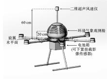
图1
大气边界层旋翼无人机的外观图"

表2
边界层旋翼无人机开展应具备的基础性能参数"
| 性能指标 | 性能参数 | |
| 动力性能 | 最大起飞重量/kg | ≤15 |
| 最大负载/kg | ≤5 | |
| 3 kg负重飞行时间/min | ≥45 | |
| 环境适用性 | 工作温度范围/℃ | -20—55 |
| 工作湿度范围/(%) | 0—100 | |
| 起降风力环境/级 | ≥6 | |
| 高空观测风力环境/级 | ≥8 | |
| 起降海拔高度/m | 4000 | |
| 观测真高/m | ≥1500 | |
| 防水等级/级 | ≥IPX5或小雨 | |
| 飞行性能 | 最大上升速度/m·s-1 | 6 |
| 最大下降速度/m·s-1 | 3 | |
| 悬停精度/m | ±0.5 | |
| 控制距离/km | ≥5 | |
| 风速≤5 m·s-1下姿态角保持性能/° | ≤3 | |
| 风速≤5 m·s-1下航向角保持性能/° | ≤5 | |

图2
2020年4月30日上午南京地区大气气温(a)、相对湿度(b)和气压(c)垂直廓线观测(实验1)"
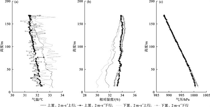
图3
2020年4月30日上午南京地区大气气温(a)、相对湿度(b)和气压(c)垂直廓线观测(实验2)"
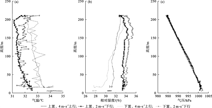
表3
2020年4月30日上午在南京地区垂直廓线观测实验1中各实验设计的误差统计量"
| 实验组 | 温度/℃ | 湿度/(%) | |||||
| 无人机 | 地面 | 差值 | 无人机 | 地面 | 差值 | ||
| 1 | 32.61 | 32.09 | 0.26 | 32.23 | 29.29 | -0.39 | |
| 2 | 31.75 | 31.49 | 0.01 | 33.83 | 30.41 | 0.09 | |
| 总体 | 32.17 | 31.79 | 0.13 | 33.04 | 29.86 | -0.14 | |
表4
2020年4月30日上午南京地区大气垂直廓线观测实验2中各实验设计的误差统计量"
| 实验组 | 温度/℃ | 湿度/(%) | |||||
| 无人机 | 地面 | 差值 | 无人机 | 地面 | 差值 | ||
| 1 | 33.54 | 32.98 | 0.30 | 29.86 | 20.00 | -1.47 | |
| 2 | 31.91 | 31.40 | 0.26 | 34.27 | 30.19 | 0.76 | |
| 总体 | 32.72 | 32.19 | 0.27 | 32.06 | 29.09 | -0.36 | |
图4
2018年1月18日14时在南京地区旋翼无人机与探空气球的0—1500 m的气温(a)、相对湿度(b)和PM2.5(c)对比观测"
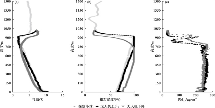

图5
2019年4月15日15时在安徽全椒县旋翼无人机与高塔风速(a)和风向(b)数据的对比"
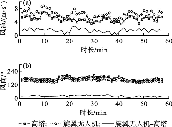
图6
2020年12月20日20时湖北荆州基于旋翼无人机0—1000 m的气温(a)、相对湿度(b)、风速(c)、风向(d)和气压(e)廓线观测"
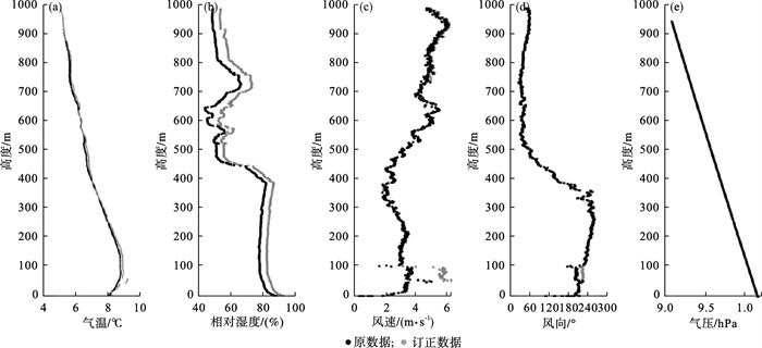
图7
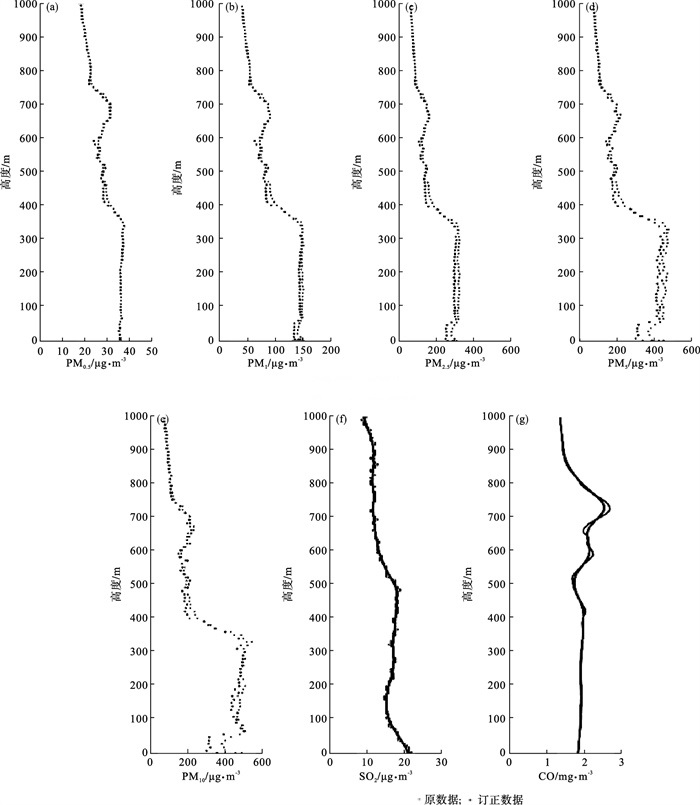
2020年12月20日20时湖北荆州基于旋翼无人机0—1000 m PM0.5 (a)、PM1.0 (b)、PM2.5 (c)、PM5 (d)、PM10 (e)、SO2 (f)和CO (g)廓线观测"
| 1 |
胡非, 洪钟祥, 雷孝恩. 大气边界层和大气环境研究进展[J]. 大气科学, 2003, 27 (4): 712- 728.
doi: 10.3878/j.issn.1006-9895.2003.04.18 |
| 2 | 陈树成, 李晓波, 崔明, 等. 不同天气条件下微波辐射计和风廓线雷达探测数据误差特征分析[J]. 气象与环境学报, 2021, 37 (1): 67- 72. |
| 3 | Stull R B . An introduction to boundary layer meteorology[M]. Dordrecht: Springer, 1988. |
| 4 | 卞林根, 程彦杰, 王欣, 等. 北京大气边界层中风和温度廓线的观测研究[J]. 应用气象学报, 2002, 13 (S1): 13- 25. |
| 5 |
Saggiani G M , Teodorani B . Rotary wing UAV potential applications: an analytical study through a matrix method[J]. Aircraft Engineering and Aerospace Technology, 2004, 76 (1): 6- 14.
doi: 10.1108/00022660410514955 |
| 6 |
马舒庆, 赵志强, 邢毅. VAISALA探空技术及中国探空技术的发展[J]. 气象科技, 2005, 33 (5): 390- 393.
doi: 10.3969/j.issn.1671-6345.2005.05.002 |
| 7 |
Rahn D A , Mitchell C.J . Diurnal climatology of the boundary layer in Southern California using AMDAR temperature and wind profiles[J]. Journal of Applied Meteorology and Climatology, 2016, 55 (5): 1123- 1137.
doi: 10.1175/JAMC-D-15-0234.1 |
| 8 |
陈洪滨, 郑国光. 基于商用运输平台的流动大气和环境监测系统[J]. 地球科学进展, 2005, 20 (5): 520- 524.
doi: 10.3321/j.issn:1001-8166.2005.05.006 |
| 9 |
Cassano J J . Observations of atmospheric boundary layer temperature profiles with a small unmanned aerial vehicle[J]. Antarctic Science, 2014, 26 (2): 205- 213.
doi: 10.1017/S0954102013000539 |
| 10 | 刘超, 花丛, 张恒德, 等. L波段探空雷达秒数据在污染天气边界层分析中的应用[J]. 气象, 2017, 43 (5): 591- 597. |
| 11 | 夏俊荣, 吴丹, 齐冰, 等. 华北香河站一次霾污染事件的综合观测研究[J]. 气象与环境科学, 2016, 39 (2): 10- 17. |
| 12 |
李建强, 李新生, 董文晓, 等. RPG-HATPRO微波辐射计反演的温度和湿度数据适用性分析[J]. 气象与环境学报, 2017, 33 (6): 89- 95.
doi: 10.3969/j.issn.1673-503X.2017.06.012 |
| 13 | 齐佳慧, 郝巨飞, 耿飞. CFL-06型风廓线雷达与L波段探空雷达测风对比分析[J]. 气象与环境科学, 2019, 42 (2): 135- 143. |
| 14 | 严孝鑫, 张航, 周鑫, 等. 基于四旋翼无人机的环境监测系统[J]. 自动化与仪器仪表, 2016, (10): 85- 86. |
| 15 | Schiano F, Alonso-Mora J, Rudin K, et al. Towards estimation and correction of wind effects on a quadrotor UAV[C]//Proceedings of IMAV 2014: International Micro Air Vehicle Conference and Competition. Delft: IMAV, 2014: 134-141. |
| 16 |
Villa T F , Salimi F , Morton K , et al. Development and validation of a UAV based system for air pollution measurements[J]. Sensors, 2016, 16 (12): 2202.
doi: 10.3390/s16122202 |
| 17 |
Altstädter B , Platis A , Wehner B , et al. ALADINA-an unmanned research aircraft for observing vertical and horizontal distributions of ultrafine particles within the atmospheric boundary layer[J]. Atmospheric Measurement Techniques, 2015, 8 (4): 1627- 1639.
doi: 10.5194/amt-8-1627-2015 |
| 18 |
Greatwood C , Richardson T S , Freer J , et al. Atmospheric sampling on ascension island using multirotor UAVs[J]. Sensors, 2017, 17 (6): 1189.
doi: 10.3390/s17061189 |
| 19 | Liu C , Huang J P , Wang Y W , et al. Vertical distribution of PM2.5 and interactions with the atmospheric boundary layer during the development stage of a heavy haze pollution event[J]. Science of the Total Environment, 2019, 704, 135329. |
| 20 |
Zhu J , Zhu B , Huang Y , et al. PM2.5 vertical variation during a fog episode in a rural area of the Yangtze River Delta, China[J]. Science of the Total Environment, 2019, 685, 555- 563.
doi: 10.1016/j.scitotenv.2019.05.319 |
| 21 | 陶昕宇, 黄建平, 谢晓金, 等. 气溶胶辐射效应对边界层结构及夹卷特征影响的观测分析[J]. 大气科学, 2020, 44 (6): 1213- 1223. |
| 22 |
牛记, 王仁波. 基于六旋翼无人机的PM2.5低空测量系统[J]. 科学技术与工程, 2014, 14 (36): 72- 76.
doi: 10.3969/j.issn.1671-1815.2014.36.014 |
| 23 |
Hardin P J , Hardin T J . Small-scale remotely piloted vehicles in environmental research[J]. Geography Compass, 2010, 4 (9): 1297- 1311.
doi: 10.1111/j.1749-8198.2010.00381.x |
| 24 |
Cao C , Lee X , Muhlhausen J , et al. Measuring landscape albedo using unmanned aerial vehicles[J]. Remote Sensing, 2018, 10 (11): 1812.
doi: 10.3390/rs10111812 |
| 25 |
Zhang C H , Kovacs J M . The application of small unmanned aerial systems for precision agriculture: a review[J]. Precision Agriculture, 2012, 13 (6): 693- 712.
doi: 10.1007/s11119-012-9274-5 |
| 26 |
Watts A C , Ambrosia V G , Hinkley E A . Unmanned aircraft systems in remote sensing and scientific research: classification and considerations of use[J]. Remote Sensing, 2012, 4 (6): 1671- 1692.
doi: 10.3390/rs4061671 |
| 27 | 孙中宇, 陈燕乔, 杨龙, 等. 轻小型无人机低空遥感及其在生态学中的应用进展[J]. 应用生态学报, 2017, 28 (2): 528- 536. |
| 28 |
Mancini F , Dubbini M , Gattelli M , et al. Using unmanned aerial vehicles (UAV) for high-resolution reconstruction of topography: the structure from motion approach on coastal environments[J]. Remote Sensing, 2013, 5 (12): 6880- 6898.
doi: 10.3390/rs5126880 |
| 29 |
郄秀书, 吕达仁, 陈洪滨, 等. 大气探测高技术及应用研究进展[J]. 大气科学, 2008, 32 (4): 867- 881.
doi: 10.3878/j.issn.1006-9895.2008.04.14 |
| 30 | 魏东, 孙继松, 雷蕾, 等. 三种探空资料在各类强对流天气中的应用对比分析[J]. 气象, 2011, 37 (4): 412- 422. |
| 31 |
Roldán J J , Joossen G , Sanz D , et al. Mini-UAV based sensory system for measuring environmental variables in greenhouses[J]. Sensors, 2015, 15 (2): 3334- 3350.
doi: 10.3390/s150203334 |
| 32 |
Villa T F , Gonzalez F , Miljievic B , et al. An overview of small unmanned aerial vehicles for air quality measurements: Present applications and future prospectives[J]. Sensors, 2016, 16 (7): 1072.
doi: 10.3390/s16071072 |
| 33 | Cassano J J , Seefeldt M W , Palo S , et al. Observations of the atmosphere and surface state over Terra Nova Bay, Antarctica, using unmanned aerial systems[J]. Earth System Science Data, 2015, 8 (1): 115- 126. |
| 34 | Neumann P P . Gas source localization and gas distribution mapping with a micro-drone[M]. Berlin: Freie University, 2013. |
| 35 | Javier M C. Quadrotor UAV for wind profile characterization[D]. Universidad Carlos Ⅲ de Madrid. Available at: http://e-archivo.uc3m.es/handle/10016/18105. |
| 36 |
Peng Z R , Wang D S , Wang Z Y , et al. A study of vertical distribution patterns of PM2.5 concentrations based on ambient monitoring with unmanned aerial vehicles: a case in Hangzhou, China[J]. Atmospheric Environment, 2015, 123, 357- 369.
doi: 10.1016/j.atmosenv.2015.10.074 |
| 37 | 李杨, 马舒庆, 贾小芳, 等. 无人直升机搭载大气颗粒物采样装置的前期地面评估[J]. 气象与环境科学, 2016, 39 (2): 132- 136. |
| 38 | WMO. Guide to meteorological instruments and methods of observation. WMO-No. 8(7th ed)[R]. Geneva, Switzerland: WMO, 2008. |
| 39 |
Palomaki R T , Rose N T , Bossche M , et al. Wind estimation in the lower atmosphere using multirotor aircraft[J]. Journal of Atmospheric and Oceanic Technology, 2017, 34 (5): 1183- 1191.
doi: 10.1175/JTECH-D-16-0177.1 |
| 40 |
Kimball S K , Montalvo C J , Mulekar M S . Assessing iMET-XQ performance and optimal placement on a small off-the-shelf, rotary-wing UAV, as a function of atmospheric conditions[J]. Atmosphere, 2020, 11 (6): 660.
doi: 10.3390/atmos11060660 |
| 41 | Haering Jr E A. Airdata calibration of a high-performance aircraft for measuring atmospheric wind profiles. NASA Technical Menorandum 101714[R]. Washington: NASA, 1990. |
| 42 | 韩彦霞, 王成刚, 严家德, 等. 新型边界层气象探空系统的开发与应用[J]. 气象科技, 2017, 45 (5): 804- 810. |
| 43 |
姚雯, 马颖, 徐文静. L波段电子探空仪相对湿度误差研究及其应用[J]. 应用气象学报, 2008, 19 (3): 356- 361.
doi: 10.3969/j.issn.1001-7313.2008.03.012 |
| 44 |
陶士伟, 郝民, 赵琳娜. AMDAR观测资料分析及质量控制[J]. 气象, 2009, 35 (12): 65- 73.
doi: 10.7519/j.issn.1000-0526.2009.12.009 |
| 45 | Riccardi F. Wind tunnel testing of a variable-pitch quadrotor UAV isolated rotor[C]//Proceedings of the 41st European Rotorcraft Forum. Munich, Germany, 2015. |
| 46 |
屈耀红, 邢哲文, 袁冬莉, 等. 基于悬停四旋翼位置姿态信息的风场估计方法研究[J]. 西北工业大学学报, 2016, 34 (4): 683- 689.
doi: 10.3969/j.issn.1000-2758.2016.04.020 |
| 47 |
Prudden S , Fisher A , Marino M , et al. Measuring wind with small unmanned aircraft systems[J]. Journal of Wind Engineering and Industrial Aerodynamics, 2018, 176, 197- 210.
doi: 10.1016/j.jweia.2018.03.029 |
| 48 | 马舒庆, 汪改, 潘毅, 等. 微型无人驾驶飞机气象探空系统[J]. 南京气象学院学报, 1998, 21 (4): 715- 721. |
| 49 |
周伟静, 沈怀荣. 一种基于小型无人机的风场测量方法[J]. 测试技术学报, 2009, 23 (4): 297- 302.
doi: 10.3969/j.issn.1671-7449.2009.04.004 |
| 50 | 沈怀荣, 邵琼玲, 王盛军, 等. 无人机气象探测技术[M]. 北京: 清华大学出版社, 2010. |
| 51 | 徐家平, 李永, 吴泓, 等. 无人机安全控制设备及方法[P]. 中国: 111413992A. 2020-07-14. |
| 52 | 中国民用航空局飞行标准司. 轻小型无人机运行规定(试行)[EB/OL]. (2015-12-29). http://www.caac.gov.cn/XXGK/XXGK/GFXWJ/201601/P020170527591647559640.pdf. |
| 53 | 工业和信息化部装备工业司. 无人驾驶航空器飞行管理暂行条例(征求意见稿)[EB/OL]. (2018-01-26). http://www.miit.gov.cn/cms_files/filemanager/oldfile/miit/n1278117/n1648113/c6037419/part/6037423.doc. |
| 54 |
李伟, 邢毅, 马舒庆. 国产GTS1探空仪与VAISALA公司RS92探空仪对比分析[J]. 气象, 2009, 35 (10): 97- 102.
doi: 10.7519/j.issn.1000-0526.2009.10.012 |
| 55 |
支星, 谈建国, 孙兰东. 1961-2017年中国华东区域高空温度变化特征[J]. 气象与环境学报, 2021, 37 (2): 48- 55.
doi: 10.3969/j.issn.1673-503X.2021.02.007 |
| 56 |
陈哲, 杨溯, 刘靓珂. 1979-2012年中国探空相对湿度资料的非均一性检验与订正[J]. 气象, 2015, 41 (11): 1374- 1382.
doi: 10.7519/j.issn.1000-0526.2015.11.007 |
| 57 |
Nakamura R , Mahrt L . Air temperature measurement errors in naturally ventilated radiation shields[J]. Journal of Atmospheric and Oceanic Technology, 2005, 22 (7): 1046- 1058.
doi: 10.1175/JTECH1762.1 |
| 58 | 王昊哲, 孙鉴泞, 朱莲芳, 等. 系留气艇探测风速的误差订正及其应用评估[J]. 气象科学, 2013, 33 (5): 485- 491. |
| 59 | 杨旭, 王慧瑜. 辐射误差订正方法改变对中国探空资料温度序列的影响[J]. 气象与环境学报, 2015, 31 (4): 103- 106. |
| 60 | 中国气象局. 常规高空气象观测业务规范[M]. 北京: 气象出版社, 2010. |
| [1] | 胡春梅, 刘德, 陈道劲. 重庆地区两次连续空气污染天气过程对比分析[J]. 气象与环境学报, 2016, 32(1): 25-32. |
| [2] | 黄艇,宋煜,肖韶荣,盖晓波. 2007年冬季大连市区气溶胶垂直剖面特征[J]. 气象与环境学报, 2009, 25(4): 31-35. |
| [3] | 杨洪斌,刘万军,赵国珍,马雁军. 沿海地区大气边界层扩散特征探讨[J]. 气象与环境学报, 2000, 16(2): 23-25. |
| 阅读次数 | ||||||
|
全文 |
|
|||||
|
摘要 |
|
|||||
|