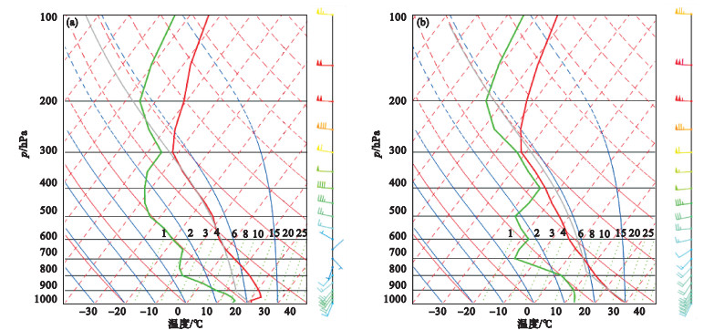
| 1 |
陈涛, 代刊, 张芳华. 一次华北飑线天气过程中环境条件与对流发展机制研究[J]. 气象, 2013, 39 (8): 945- 954.
|
| 2 |
刘飞, 肖鹏, 黄宁立, 等. 上海地区两次强对流天气过程灾害成因及预警研究[J]. 气象与环境学报, 2017, 33 (2): 28- 36.
|
| 3 |
孙继松, 戴建华, 何立富, 等. 强对流天气预报的基本原理与技术方法[M]. 北京: 气象出版社, 2014: 52- 58.
|
| 4 |
俞小鼎, 姚秀萍, 熊廷南, 等. 多普勒天气雷达原理与业务应用[M]. 北京: 气象出版社, 2006: 123
|
| 5 |
农孟松, 翟丽萍, 屈梅芳, 等. 广西一次飑线大风天气的成因和预警分析[J]. 气象, 2014, 40 (12): 1491- 1499.
doi: 10.7519/j.issn.1000-0526.2014.12.007
|
| 6 |
马中元, 苏俐敏, 谌芸, 等. 一次强飑线及飑前中小尺度系统特征分析[J]. 气象, 2014, 40 (8): 916- 929.
|
| 7 |
王秀明, 俞小鼎, 周小刚, 等. "6.3"区域致灾雷暴大风形成及维持原因分析[J]. 高原气象, 2012, 31 (2): 504- 514.
|
| 8 |
单乃超, 周后福, 褚保亮, 等. 2017年5月14日合肥地区雷暴大风过程机理分析[J]. 气象与环境学报, 2019, 35 (5): 1- 9.
|
| 9 |
马申佳, 何宏让, 陈超辉, 等. 基于对流尺度集合预报的飑线结构特征模拟与改善[J]. 气象与环境学报, 2019, 35 (1): 1- 9.
|
| 10 |
梁建宇, 孙建华. 2009年6月一次飑线过程灾害性大风的形成机制[J]. 大气科学, 2012, 36 (2): 316- 336.
|
| 11 |
王强, 唐明辉, 王起唤, 等. 湖南不同季节飑线过程的对比[J]. 干旱气象, 2018, 36 (5): 782- 793.
|
| 12 |
陈云辉, 蔡菁, 马中元, 等. 江西两次不同季节强飑线天气过程对比分析[J]. 气象水文海洋仪器, 2011, 28 (2): 43- 50.
|
| 13 |
费海燕, 王秀明, 周小刚, 等. 中国强雷暴大风的气候特征和环境参数分析[J]. 气象, 2016, 42 (12): 1513- 1521.
|
| 14 |
方翀, 王西贵, 盛杰, 等. 华北地区雷暴大风的时空分布及物理量统计特征分析[J]. 高原气象, 2017, 36 (5): 1368- 1385.
|
| 15 |
柴东红, 杨晓亮, 吴紫煜, 等. 京津冀地区雷暴大风天气的统计分析[J]. 暴雨灾害, 2017, 36 (3): 193- 199.
|
| 16 |
王秀明, 周小刚, 俞小鼎. 雷暴大风环境特征及其对风暴结构影响的对比研究[J]. 气象学报, 2013, 71 (5): 839- 852.
|
| 17 |
张一平, 牛淑贞, 席世平, 等. 东北低涡槽后型河南强对流过程的天气学特征分析[J]. 暴雨灾害, 2011, 30 (3): 193- 201.
|
| 18 |
蓝渝, 郑永光, 毛冬艳, 等. 华北区域冰雹天气分型及云系特征[J]. 应用气象学报, 2014, 25 (5): 538- 549.
|
| 19 |
苏爱芳, 张宁, 袁小超, 等. 河南"7.14"强降水和"8.02"雷暴大风过程β中尺度对流系统对比分析[J]. 暴雨灾害, 2016, 35 (2): 126- 137.
|
| 20 |
王福侠, 俞小鼎, 裴宇杰, 等. 河北省雷暴大风的雷达回波特征及预报关键点[J]. 应用气象学报, 2016, 27 (3): 342- 351.
|
| 21 |
张宁, 苏爱芳, 史一丛. 2014年一次飑线的发展维持原因分析[J]. 气象, 2017, 43 (11): 1383- 1392.
|
| 22 |
马鸿青, 张江涛, 李彦, 等. 河北保定"7.9"致灾雷暴大风环境场与风暴特征[J]. 干旱气象, 2019, 37 (4): 613- 621.
|
| 23 |
Li Y D , Gao S T , Liu J W . Assessment of several moist adiabatic processes associated with convective energy calculation[J]. Advances in Atmospheric Sciences, 2004, 21 (6): 941- 950.
|
 ),杨敏3,*(