主办单位:中国气象局沈阳大气环境研究所
国际刊号:ISSN 1673-503X
国内刊号:CN 21-1531/P

气象与环境学报 ›› 2022, Vol. 38 ›› Issue (6): 39-47.doi: 10.3969/j.issn.1673-503X.2022.06.005

• 论文 • 上一篇    下一篇

2018—2019年大连地区冷流性与非冷流性两次大雪天气过程对比分析

李燕1(),赛瀚1,辛明月2,刘晓初1,程航1,李昊1   

  1. 1. 大连市气象台, 辽宁大连 116001
    2. 盘锦市气象局, 辽宁盘锦 124010
  • 收稿日期:2020-11-12 出版日期:2022-12-28 发布日期:2022-12-27
  • 作者简介:李燕, 女, 1973年生, 正研级高级工程师, 主要从事天气预报研究, E-mail: LYDW0211@163.com
  • 基金资助:
    辽宁省气象局科研项目(RC202202);辽宁省创新发展专项(CXFZ2021Z034);中国气象局沈阳大气环境研究所联合开放基金面上项目(2021SYIAEKFMS04)

Comparative analysis of cold- and non-cold-air snowfalls in Dalian from 2018 to 2019

Yan LI1(),Han SAI1,Ming-yue XIN2,Xiao-chu LIU1,Hang CHENG1,Hao LI1   

  1. 1. Dalian Meteorological Observatory, Dalian 116001, China
    2. Panjiin Meteorological Service, Panjin 124010, China
  • Received:2020-11-12 Online:2022-12-28 Published:2022-12-27

摘要:

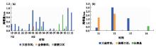
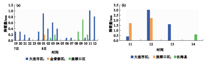
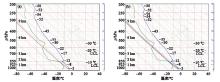
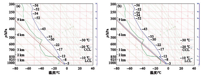
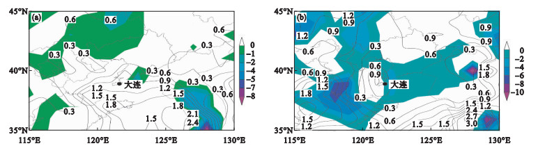
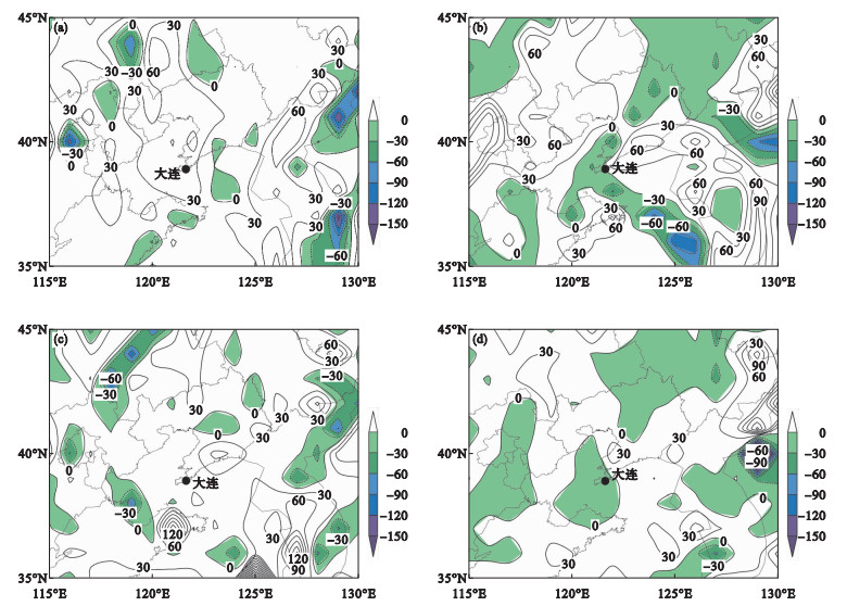
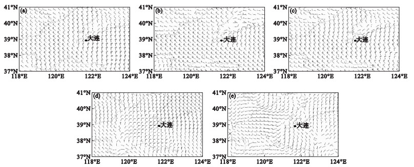
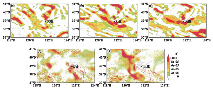
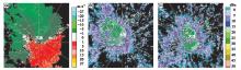
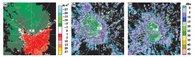
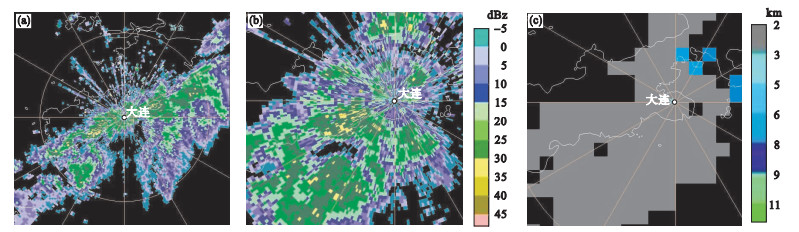
利用常规气象观测资料、再分析资料、雷达资料等, 对2018—2019年大连地区两次预报难度较大的冷流性局地降雪和非冷流性局地降雪过程进行对比分析。结果表明: 冷流性局地降雪过程500hPa以下均为西北气流场, 有较强冷平流, 1km以上风速较大。非冷流性局地降雪过程近地面至850hPa存在风切变, 近地面有辐合线, 为南到西南风, 850hPa以上有逆温层。两次降雪过程均属于不稳定性降雪, 地面均有中小尺度辐合线, 冷流性局地降雪落区位于中小尺度辐合抬升区的下游, 非冷流性局地降雪落区位于中小尺度辐合抬升区。冷流性局地降雪的水汽来自西北方干冷空气, 在经过渤海海面时, 海气作用使暖洋面水汽长时间蒸发辐合抬升。非冷流中小尺度降雪的水汽主要来自南方暖湿空气的水平输送, 水汽条件建立时间短。冷流性局地降雪雷达回波从渤海西北向东南移动, 强回波面积大; 非冷流性局地降雪雷达回波从西南向东北移动, 走向与回波移动方向基本一致。

关键词: 冷流性降雪, 非冷流性降雪, 中尺度, 网格产品

Abstract:

The two difficult prediction processes i.e.cold- and non-cold-air snowstorms in the Dalian area from 2018 to 2019 were analyzed using the data from the automatic station, conventional meteorological observation, NCEP reanalysis, Radar, and 1 km×1 km grid products.The results indicate that the process of the cold-air snowstorm has northeast airflow and strong cold advection below 500 hPa.The wind speed above 1 km is higher than that below 1 km.The process of a non-cold-air snowstorm has wind shear from near the ground to 850 hPa, a convergence line on the ground, and an inversion layer above 850 hPa.The wind direction near the ground is south and southwest.Two processes belong to unstable snowfall and both have meso and small scale convergence lines on the ground.The unstable conditions of a cold-air snowstorm are established earlier and are more unstable than that of a non-cold-air snowstorm.The cold-air snowstorm area is located downstream of the meso and small scale convergence line uplift area, while the non-cold-air snowstorm area is located in the meso and small scale convergence line uplift area.When the dry and cold air from the northwest passes through the Bohai sea surface, the air-sea interaction makes the water vapor on the warm ocean surface evaporate and converge for a long time, which is the source of the water vapor of the cold-air snowstorm.The water vapor of the non-cold-air snowstorm mainly comes from the horizontal transportation of warm and humid air in the south, and the water vapor condition is established for a short time.The cold-air snowstorm affecting Dalian has the radar echo moving from northwest to southeast and a large area of strong echo.Inversely, the non-cold-air snowstorm has the radar echo moving from southwest to northeast and moves consistent with the moving direction of the echo.

Key words: The cold-air snowstorm, The non-cold-air snowstorm, Meso-scale, Grid products

中图分类号: