主办单位:中国气象局沈阳大气环境研究所
国际刊号:ISSN 1673-503X
国内刊号:CN 21-1531/P

气象与环境学报 ›› 2020, Vol. 36 ›› Issue (2): 9-19.doi: 10.3969/j.issn.1673-503X.2020.02.002

• 论文 • 上一篇    下一篇

2016年河南省一次大范围强对流天气成因分析

崔丽曼1,2(),苏爱芳1,2,*(),张宇星3,王春晓1,2,王迪1,2   

  1. 1. 中国气象局河南省农业气象保障与应用技术重点开放实验室, 河南 郑州 450003
    2. 河南省气象台, 河南 郑州 450003
    3. 河南省气象局, 河南 郑州 450003
  • 收稿日期:2019-03-06 出版日期:2020-04-30 发布日期:2020-03-03
  • 通讯作者: 苏爱芳 E-mail:120373416@qq.com;afsu011@sohu.com
  • 作者简介:崔丽曼,女, 1982年生,高级工程师,主要从事强对流天气预警预报技术研究, E-mail:120373416@qq.com
  • 基金资助:
    2016年河南省科技攻关项目“大城市暴雨、强对流精细预报与监测预警技术研究”(162102310056);CMA气象预报业务关键技术发展专项子项目“融合多源资料的黄淮地区强对流监测预警(0-2h)技术研究”((YBGJXM(2018)-02));河南省强对流预报专家团队共同资助

Causes analysis of the formation of an extensive severe convective weather in 2016 in He'nan province

Li-man CUI1,2(),Ai-fang SU1,2,*(),Yu-xing ZHANG3,Chun-xiao WANG1,2,Di WANG1,2   

  1. 1. Key Laboratory of Agro-meteorological Safeguard Application Technique, China Meteorological Administration, Zhengzhou 450003, China
    2. He'nan Provincial Meteorological Observatory, Zhengzhou 450003, China
    3. He'nan Provincial Meteorological Service, Zhengzhou 450003, China
  • Received:2019-03-06 Online:2020-04-30 Published:2020-03-03
  • Contact: Ai-fang SU E-mail:120373416@qq.com;afsu011@sohu.com

摘要:

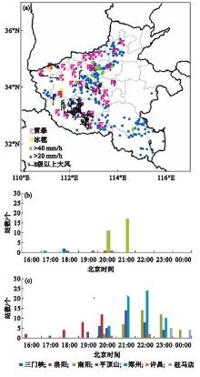
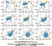
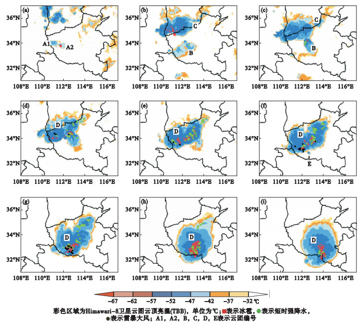
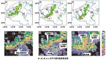
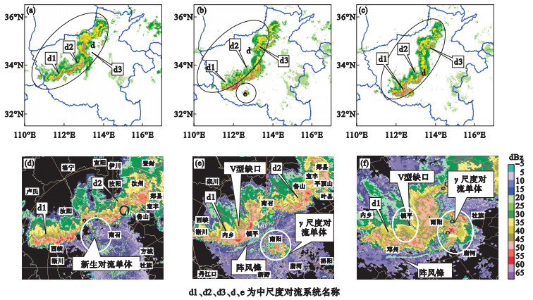
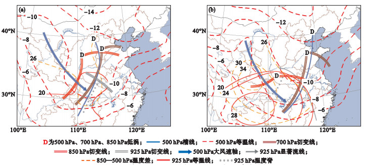
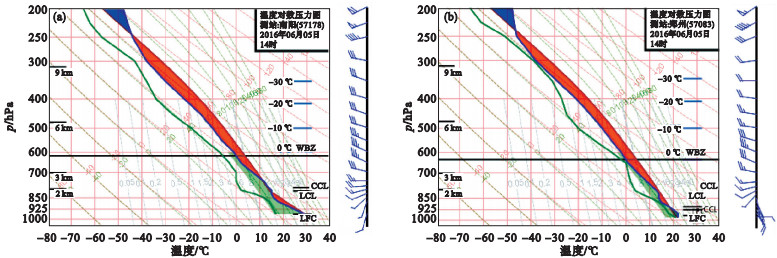
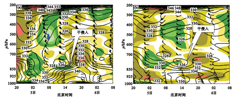
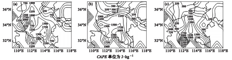
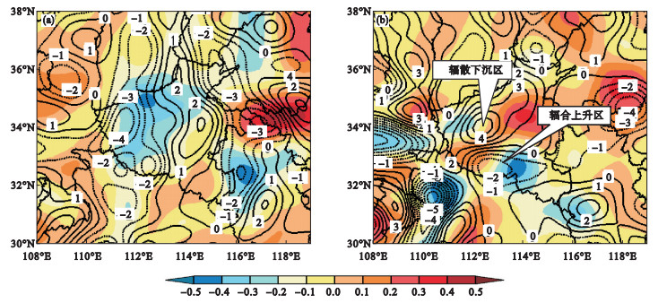
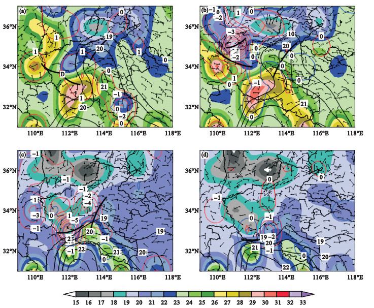
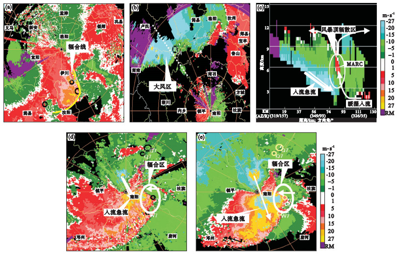
基于Himawari-8卫星资料、雷达监测资料、区域自动站和常规观测资料及ERA-Interim再分析资料,对2016年6月5日河南省大范围强对流天气的环流背景、触发条件及对流系统演变特征进行了研究。结果表明:华北冷涡背景下,高空冷平流配合低层暖脊发展、对流有效位能值激增,为中尺度对流系统发展提供了不稳定条件,地面辐合线、冷池是触发机制。河南省西南部位于高能区、不同温湿性质气团交绥区,中高层干冷空气侵入、中层以下干绝热递减率为风雹天气提供了可能;河南省中部、河南省南部位于大气可降水量大值区,深厚的湿层、较低的抬升凝结高度有利于产生强降水。高层辐散、低层辐合的抽吸作用导致豫西南上升运动强盛,雷暴高压产生的变压风增强了动力抬升,中小尺度动力辐合促使强对流回波发展。风雹天气产生于中尺度对流系统前侧云顶亮温梯度大值区,强降水出现在云顶亮温低值中心附近。雷达产品分析表明,强回波悬垂、三体散射与快速移动的弓形回波、阵风锋和后侧入流急流对提前预警冰雹、雷暴大风有很好的指示意义。925 hPa 12 h显著增温区、对流有效位能高值区和冷池出流与暖空气交绥区是强对流发展的潜势区,湿球温度0 ℃层高度与冰雹关系密切。

关键词: 中尺度对流系统, 触发机制, 弓形回波, 后侧入流急流, 冷池

Abstract:

Based on the data from the Himawari-8 satellite, Doppler weather radar, regional automatic and conventional meteorological stations, and ERA-Interim (European Centre for Medium-range Weather Forecasts Interim) reanalysis, the environmental condition, triggering mechanism and evolution of MCS (Mesoscale Convective System) of a large-scale strong storm occurred in He'nan province on June 5, 2016, were analyzed.It shows that under the background of a North China cold vortex, the cold advection at the high level, combined with the development of warm ridge and the surge of the CAPE (Convective Available Potential Energy) values, provides unstable conditions for the development of the MCS.The convergence line at the surface and cold pool is the trigger mechanism.Southwest He'nan province is located in the high-energy area, where air masses with different temperatures and humidity properties meet each other.The intrusion of cold air in the middle and high level and the adiabatic lapse rate of the dry air below the middle level provide the possibility for the hail weather.Central and southern He'nan province is located in the area having a large amount of PW (Precipitable Water), and the deep wet layer and low uplift condensation height are conductive to the production of severe precipitation.The suction of the divergence at the high level and convergence at the low level leads to a strong upward movement over the Southwest He'nan province.The dynamic uplift is enhanced by the variable pressure wind generated by the thunderstorm high pressure.The strong convection echo is developed by the small and medium scale dynamic convergence.Hail weather occurs in the area having large values of TBB (Black Body Temperature) gradient in front of MCSs, and heavy precipitation occurs near the low value center of TBB.The radar product analysis shows that the strong echo drape, TBSS (Three Body Scattering Spike) and the fast-moving bow echo, the gust front and rear inflow jet are good indicators for the early warning of hail and thunderstorm gale.The significant warming zone at 12:00 at 925 hPa, the high-value zone of CAPE and the intersection zone between the cold pool outflow and the warm air are the potential zones for the development of strong convection.The height of wet-bulb temperature with 0 ℃ is closely related to hail.

Key words: Mesoscale convective systerm (MCS), Trigger mechanism, Bow echo, Rear inflow jet, Cold pool

中图分类号: