主办单位:中国气象局沈阳大气环境研究所
国际刊号:ISSN 1673-503X
国内刊号:CN 21-1531/P
国际刊号:ISSN 1673-503X
国内刊号:CN 21-1531/P
Journal of Meteorology and Environment ›› 2022, Vol. 38 ›› Issue (1): 65-73.doi: 10.3969/j.issn.1673-503X.2022.01.009
• Articles • Previous Articles Next Articles
Rui FENG1,2( ),Rui-peng JI1,2,Jin-wen WU1,2,Wen-ying YU1,2,Dan LIU3,Ni-na CHEN1,2,Ying WANG4,Yu-shu ZHANG1,2,*()
Received:2021-05-13
Online:2022-02-28
Published:2022-03-02
Contact:
Yu-shu ZHANG
E-mail:fengrui_k@126.com;yushuzhang@126.com
CLC Number:
Rui FENG,Rui-peng JI,Jin-wen WU,Wen-ying YU,Dan LIU,Ni-na CHEN,Ying WANG,Yu-shu ZHANG. Reconstruction and spatial-temporal variation analysis of the vegetation indices in Liaoning province based on FY3/MERSI data[J]. Journal of Meteorology and Environment, 2022, 38(1): 65-73.
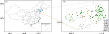
Fig.1
Locations of the research area (a) and extraction points in seven types of ground features (b)"
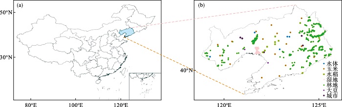
Table 1
Parameters in some channels of FY3/MERSI"
| 卫星 | 通道编号 | 中心波长/μm | 光谱带宽/nm | 空间分辨率/m | 动态范围/(%) |
| A-C | 3 | 0.650 | 50 | 250 | 100 |
| 4 | 0.865 | 50 | 250 | 100 | |
| D | 3 | 0.650 | 50 | 250 | 90 |
| 4 | 0.865 | 50 | 250 | 90 |
Table 2
Parameter settings of four fitting methods"
| 方法 | 有效值域 | 尖峰方法 | 尖峰值 | 季节 | 滑动窗口 | 迭代次数 | 频率数 | 相位偏移 |
| SG | -0.1~1.0 | 1 | 2 | 1 | 5 | 3 | - | - |
| DL | -0.1~1.0 | 1 | 2 | 1 | - | 2 | - | - |
| AG | -0.1~1.0 | 1 | 2 | 1 | - | 2 | - | - |
| HANTS | -0.1~1.0 | - | - | - | - | - | 5 | 0 |
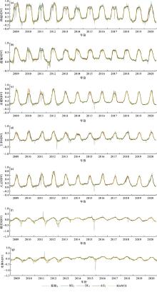
Fig.2
Comparisons between reconstruction data and original data of woodland (a), wetland (b), rice (c), corn (d), soybean (e), urban (f), water body (g) and their reconstruction data from 2009 to 2020"
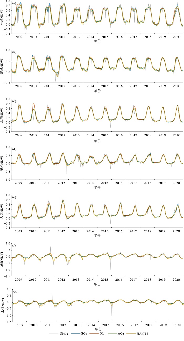
Fig.3
The correlation coefficients and RMSE between reconstruction data and original data based on the four methods in various ground features from 2009 to 2020"
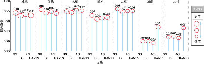

Fig.4
Spatial distributions of vegetation indices in Liaoning province from 2009 to 2020"
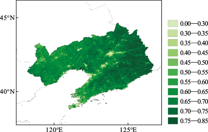
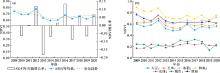
Fig.5
Inter-annual variations of the average vegetation indices in Liaoning Province (a) and mean values of various ground features (b) from 2009 to 2020"
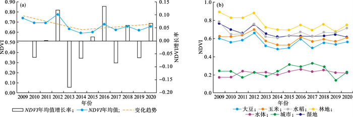
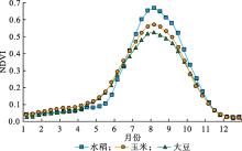
Fig.6
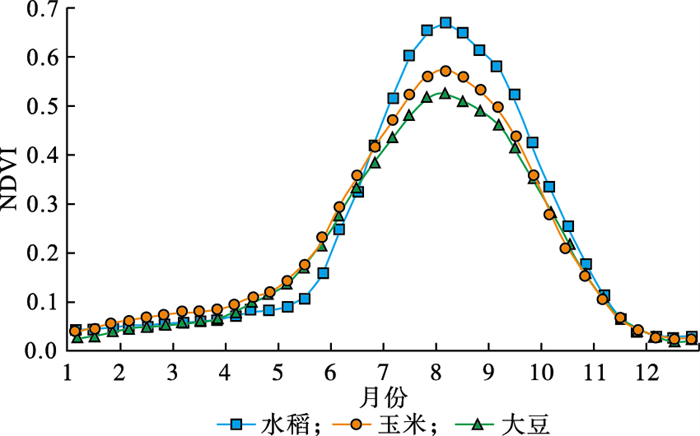
Annual vegetation index variations in ten-day values of corn, soybean and rice from 2009 to 2020"
| 1 | 冯兴兴, 王学凤, 阳辉, 等. 辽宁省春玉米生产水足迹的时空变化研究[J]. 中国水利水电科学研究院学报, 2020, 18 (6): 447- 454. |
| 2 | 张亮, 丁明军, 张华敏, 等. 1982-2015年长江流域植被覆盖度时空变化分析[J]. 自然资源学报, 2018, 33 (12): 2084- 2097. |
| 3 |
冯锐, 张玉书, 武晋雯, 等. 基于多光谱和高光谱的干旱遥感监测研究进展[J]. 灾害学, 2019, 34 (1): 162- 166.
doi: 10.3969/j.issn.1000-811X.2019.01.030 |
| 4 |
Kuchler P C , Bégué A , Simõs M , et al. Assessing the optimal preprocessing steps of MODIS time series to map cropping systems in Mato Grosso, Brazil[J]. International Journal of Applied Earth Observation and Geoinformation, 2020, 92, 102150.
doi: 10.1016/j.jag.2020.102150 |
| 5 |
Werner J P S , De M Oliveira S R , Esquerdo J C D M . Mapping cotton fields using data mining and MODIS time-series[J]. International Journal of Remote Sensing, 2020, 41 (7): 2457- 2476.
doi: 10.1080/01431161.2019.1693072 |
| 6 |
Páscoa P , Gouveia C M , Kurz-Besson C . A simple method to identify potential groundwater-dependent vegetation using NDVI MODIS[J]. Forests, 2020, 11 (2): 147.
doi: 10.3390/f11020147 |
| 7 |
程琳琳, 李玉虎, 孙海元, 等. 京津冀MODIS长时序增强型植被指数拟合重建方法适用性研究[J]. 农业工程学报, 2019, 35 (11): 148- 158.
doi: 10.11975/j.issn.1002-6819.2019.11.017 |
| 8 | Chen J , Jönsson P , Tamura M , et al. A simple method for reconstructing a high-quality NDVI time-series data set based on the Savitzky-Golay filter[J]. Remote Sensing of Environment, 2004, 91 (3/4): 332- 344. |
| 9 |
Sellers P J , Tucker C J , Collatz G J , et al. A revised land surface parameterization(SiB2)for atmospheric GCMs.Part II: the generation of global fields of terrestrial biophysical parameters from satellite data[J]. Journal of Climate, 1996, 9 (4): 706- 737.
doi: 10.1175/1520-0442(1996)009<0706:ARLSPF>2.0.CO;2 |
| 10 |
Ma M G , Veroustraete F . Reconstructing pathfinder AVHRR Land NDVI time-series data for the northwest of China[J]. Advances in Space Research, 2006, 37 (4): 835- 840.
doi: 10.1016/j.asr.2005.08.037 |
| 11 |
Roerink G J , Menenti M , Verhoef W . Reconstructing cloudfree NDVI composites using Fourier analysis of time series[J]. International Journal of Remote Sensing, 2000, 21 (9): 1911- 1917.
doi: 10.1080/014311600209814 |
| 12 |
Bradley B A , Jacob R W , Hermance J F , et al. A curve fitting procedure to derive inter-annual phenologies from time series of noisy satellite NDVI data[J]. Remote Sensing of Environment, 2007, 106 (2): 137- 145.
doi: 10.1016/j.rse.2006.08.002 |
| 13 |
Jonsson P , Eklundh L . Seasonality extraction by function fitting to time-series of satellite sensor data[J]. IEEE Transactions on Geoscience and Remote Sensing, 2002, 40 (8): 1824- 1832.
doi: 10.1109/TGRS.2002.802519 |
| 14 |
Beck P S A , Atzberger C , HØgda K A , et al. Improved monitoring of vegetation dynamics at very high latitudes: a new method using MODIS NDVI[J]. Remote Sensing of Environment, 2006, 100 (3): 321- 334.
doi: 10.1016/j.rse.2005.10.021 |
| 15 | 耿丽英, 马明国. 长时间序列NDVI数据重建方法比较研究进展[J]. 遥感技术与应用, 2014, 29 (2): 362- 368. |
| 16 | 杨军, 董超华, 卢乃锰, 等. 中国新一代极轨气象卫星——风云三号[J]. 气象学报, 2009, 67 (4): 501- 509. |
| 17 | 冯锐, 于文颖, 纪瑞鹏, 等. FY3B/MERSI数据的湖泊湿地面积提取对比分析[J]. 测绘科学, 2017, 42 (7): 147- 152. |
| 18 | 朱爱军, 胡秀清, 林曼筠, 等. 风云三号D气象卫星全球数据获取方法及数据分发[J]. 海洋气象学报, 2018, 38 (3): 1- 10. |
| 19 |
刘丹, 冯锐, 于成龙, 等. 基于植被指数的春玉米干旱响应遥感监测[J]. 农业工程学报, 2019, 35 (20): 152- 161.
doi: 10.11975/j.issn.1002-6819.2019.20.019 |
| 20 |
顾娟, 李新, 黄春林. NDVI时间序列数据集重建方法述评[J]. 遥感技术与应用, 2006, 21 (4): 391- 395.
doi: 10.3969/j.issn.1004-0323.2006.04.024 |
| 21 | 杨刚. 遥感数据时域滤波与重建的谐波分析扩展方法研究[D]. 武汉: 武汉大学, 2016. |
| 22 | 侯东, 潘耀忠, 张锦水, 等. 农区MODIS植被指数时间序列数据重建[J]. 农业工程学报, 2010, 26 (S1): 206- 212. |
| 23 | 魏瑞琪, 李林峰, 仙巍, 等. 利用TIMESAT软件和时间序列卫星影像提取新疆石河子棉花种植区域[J]. 湖北农业科学, 2018, 57 (4): 105- 112. |
| 24 |
刘倩楠, 岳彩荣, 欧阳志云, 等. 基于MODIS-NDVI时序数据的重庆市植被变化研究[J]. 测绘与空间地理信息, 2012, 35 (3): 99- 102.
doi: 10.3969/j.issn.1672-5867.2012.03.030 |
| 25 | 朱慧. 重庆地区NDVI时间序列重建研究[D]. 重庆: 重庆师范大学, 2017. |
| 26 | 李杭燕, 颉耀文, 马明国. 时序NDVI数据集重建方法评价与实例研究[J]. 遥感技术与应用, 2009, 24 (5): 596- 602. |
| 27 | 宋春桥, 游松财, 柯灵红, 等. 藏北地区三种时序NDVI重建方法与应用分析[J]. 地球信息科学学报, 2011, 13 (1): 133- 143. |
| 28 |
张晗, 任志远. 多种时序NDVI重建方法比较与应用分析[J]. 中国农业科学, 2014, 47 (15): 2998- 3008.
doi: 10.3864/j.issn.0578-1752.2014.15.010 |
| 29 |
李晶, 王婉昭, 刘东明, 等. 2017年辽宁省春夏季精细化气象干旱监测评估[J]. 气象与环境学报, 2019, 35 (3): 100- 105.
doi: 10.3969/j.issn.1673-503X.2019.03.013 |
| 30 |
马永忠, 黄英华, 刁军, 等. 辽西地区降水农业满足度与干旱发生规律分析[J]. 气象与环境学报, 2016, 32 (5): 131- 138.
doi: 10.3969/j.issn.1673-503X.2016.05.018 |
| 31 | 林毅, 李倩, 王宏博, 等. 干旱条件下春玉米高光谱特征及土壤含水量反演[J]. 生态学杂志, 2016, 35 (5): 1323- 1329. |
| 32 | 李军, 朱慧. 重庆地区MODIS/NDVI时间序列数据重建研究[J]. 地理科学, 2017, 37 (3): 437- 444. |
| 33 | 李晶, 邰文飞, 秦元萍, 等. 归一化植被指数时序数据拟合算法对比分析[J]. 中国矿业, 2016, 25 (S2): 317- 323. |
| 34 | 宋春桥, 柯灵红, 游松财, 等. 基于TIMESAT的3种时序NDVI拟合方法比较研究——以藏北草地为例[J]. 遥感技术与应用, 2011, 26 (2): 147- 155. |
| 35 | 王乾坤, 于信芳, 舒清态, 等. MODIS EVI时序数据重建方法及拟合分析[J]. 地球信息科学学报, 2015, 17 (6): 732- 741. |
| 36 | 卫炜, 吴文斌, 李正国, 等. 时间序列植被指数重构方法比对研究[J]. 中国农业资源与区划, 2014, 35 (1): 34- 43. |
| 37 | 邹明亮, 周妍妍, 曾建军, 等. 基于HANTS算法的疏勒河流域荒漠化时空动态监测[J]. 西北师范大学学报: 自然科学版, 2018, 54 (2): 88- 94. |
| 38 | 王玮, 郭铌, 沙莎, 等. 我国西北地区东部时间序列NDVI数据集重建方法比较研究[J]. 草业学报, 2016, 25 (8): 1- 13. |
| 39 | 国志兴, 王宗明, 宋开山, 等. 1982-2003年东北地区植被覆盖变化特征分析[J]. 西北植物学报, 2008, 28 (1): 155- 163. |
| 40 | 孙立双, 马运涛, 毕天平, 等. 辽宁地区不同地表覆盖类型EVI和NDVI特征[J]. 沈阳建筑大学学报: 自然科学版, 2013, 29 (6): 1024- 1029. |
| [1] | Zheng-qiang GU,Qiang GONG,Li-du SHEN,Hong XU,Dong-lei MA,Ling ZHU,Hua CHAO,Dong-lei FENG. Applicability analysis of linear calculation for missing data of wind tower on typical terrain in Liaoning province [J]. Journal of Meteorology and Environment, 2021, 37(6): 93-99. |
| [2] | TIAN Lei, PEI Lin, CHEN Yu-gang, XIA Jiang-jiang, WANG Xiang. Climatic data reconstruction of haze days and its temporal-spatial characteristics in Bengbu area from 1970 to 2015 [J]. Journal of Meteorology and Environment, 2018, 34(5): 39-46. |
| [3] | WANG Ling LIU Hailong. Impacts of climate change on vegetation in Chongqing karst region [J]. Journal of Meteorology and Environment, 2007, 23(1): 6-11. |
| Viewed | ||||||
|
Full text |
|
|||||
|
Abstract |
|
|||||
|