主办单位:中国气象局沈阳大气环境研究所
国际刊号:ISSN 1673-503X
国内刊号:CN 21-1531/P
国际刊号:ISSN 1673-503X
国内刊号:CN 21-1531/P
Journal of Meteorology and Environment ›› 2022, Vol. 38 ›› Issue (3): 1-10.doi: 10.3969/j.issn.1673-503X.2022.03.001
• Articles • Previous Articles Next Articles
Shi-bo GENG1,2( ),Kui-zhi CAI2,*(),Ying WANG2,Fu-ran ZHOU3,Guang-liang XIAO2,Hai-liang HUANG2,Xiao-ling CHAI4
Received:2021-07-06
Online:2022-06-28
Published:2022-07-23
Contact:
Kui-zhi CAI
E-mail:gengshibo2015@163.com;59595455@qq.com
CLC Number:
Shi-bo GENG,Kui-zhi CAI,Ying WANG,Fu-ran ZHOU,Guang-liang XIAO,Hai-liang HUANG,Xiao-ling CHAI. Observational analysis of EF4 tornadic supercell storm in Kaiyuan of Liaoning province on July 3, 2019[J]. Journal of Meteorology and Environment, 2022, 38(3): 1-10.
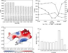
Fig.1
Distribution of PWV from 15:30 to 16:30 in Liaoning province (a), variations of wind profile radar observation from 16:35 to 18:05 in Shenyang (b), and meteorological elements at the automatic meteorological station of Kaiyuan from 12:00 to 20:00 (c, d) on July 3, 2019"
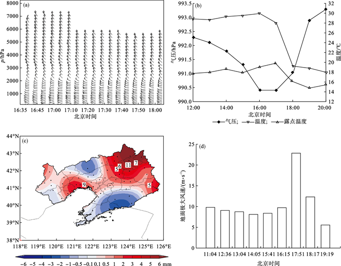
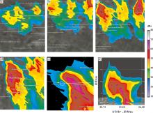
Fig.2
Distributions of radar reflectivity output at 0.5° elevation of radar at 16:24 (a), 16:36 (b), 16:54 (c), 17:00 (d), 17:24 (e) and cross-section of reflectivity at 17:24 (f) on July 3, 2019 in Shenyang"
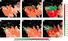
Fig.3
Distributions of elevation radial velocity at 0.5° (a), 1.5° (b), 2.4° (c) at 17:00 before the supercell storm formation and at 0.5° (d), 1.5° (e), and 2.4° (f) at 17:18 after the supercell storm formation"


Fig.4
Distributions of temporal evolution of potential vorticity and wind vectors at 1000 hPa at 16:00 (a), 17:00 (b), 18:00 (c), and 19:00 (d) on July 3, 2019"

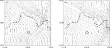
Fig.5
Distributions of the flow field of horizontal vorticity (ξx, ξy) at 975 hPa at 16:00 (a) and 17:00 (b) on July 3, 2019"
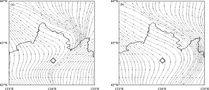
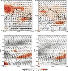
Fig.6
Distributions of vertical vorticity, vertical velocity, and horizontal wind field at 850 hPa at 17:00 (a) and 18:00 (b), and vertical vorticity profile, vertical velocity profile, horizontal wind field along the latitude of 42.53 °N at 17:00 (c) and 18:00 (d) on July 3, 2019"
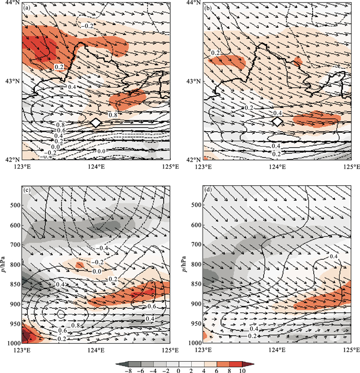
Fig.7
Distributions of storm-relative helicity on 17:00 (a) and 18:00 (b) on July 3, 2019"

| 1 | Browning K A . Cellular structures of convective storms[J]. Meteorological Magazine, 1962, 91 (1085): 341- 350. |
| 2 |
Marwitz J D . The structure and motion of severe hail storms.Part Ⅰ, Ⅱ, Ⅲ[J]. Journal of Applied Meteorology, 1972, 11 (1): 166- 201.
doi: 10.1175/1520-0450(1972)011<0166:TSAMOS>2.0.CO;2 |
| 3 |
Edwards R , Ladue J G , Ferree J T , et al. Tornado Intensity Estimation: Past, Present and Future[J]. Bulletin of the American Meteorological Society, 2013, 94 (5): 641- 653.
doi: 10.1175/BAMS-D-11-00006.1 |
| 4 |
Browning K A , Ludlam F H . Airflow in convective storms[J]. Quarterly Journal of the Royal Meteorological Society, 1962, 88 (376): 117- 135.
doi: 10.1002/qj.49708837602 |
| 5 |
Browning K A , Donaldson R J . Airflow and structure of at ornadic storm[J]. Journal of the Atmospheric Sciences, 1963, 20 (6): 533- 545.
doi: 10.1175/1520-0469(1963)020<0533:AASOAT>2.0.CO;2 |
| 6 |
Browning K A . Airflow and precipitation trajectories within severe local storms which travel to the right of the winds[J]. Journal of the Atmospheric Sciences, 1964, 21 (6): 634- 639.
doi: 10.1175/1520-0469(1964)021<0634:AAPTWS>2.0.CO;2 |
| 7 |
Ray P S , Doviak R J , Wallker G B , et al. Dual-Doppler observation of a tornadic storm[J]. Journal of Applied Meteorology, 1975, 14 (8): 1521- 1530.
doi: 10.1175/1520-0450(1975)014<1521:DDOOAT>2.0.CO;2 |
| 8 |
Burgess D W , Lemon L R , Brown R A . Tornado characteristics revealed by Doppler radar[J]. Geophysical Research Letters, 1975, 2 (5): 183- 184.
doi: 10.1029/GL002i005p00183 |
| 9 |
Brown R A , Lemon L R , Burgess D W . Tornado Detection by Pulsed Doppler Radar[J]. Monthly Weather Review, 1978, 106 (1): 29- 38.
doi: 10.1175/1520-0493(1978)106<0029:TDBPDR>2.0.CO;2 |
| 10 |
Markowski , Pa ul , M . An Idealized Numerical Simulation Investigation of the Effects of Surface Drag on the Development of Near-Surface Vertical Vorticity in Supercell Thunderstorms[J]. Journal of the Atmospheric Sciences, 2016, 73 (11): 4349- 4385.
doi: 10.1175/JAS-D-16-0150.1 |
| 11 |
Trapp J R , Davies-Jones R . Tornadogenesis with and without a Dynamic Pipe Effect[J]. Journal of the Atmospheric Sciences, 1997, 54 (1): 113- 133.
doi: 10.1175/1520-0469(1997)054<0113:TWAWAD>2.0.CO;2 |
| 12 |
Trapp R J , Mitchell E D , Tipton G A , et al. Descending and Nondescending Tornadic Vortex Signatures Detected by WSR-88Ds[J]. Weather and Forecasting, 1999, 14 (5): 625- 639.
doi: 10.1175/1520-0434(1999)014<0625:DANTVS>2.0.CO;2 |
| 13 | 郑媛媛, 朱红芳, 方翔, 等. 强龙卷超级单体风暴特征分析与预警研究[J]. 高原气象, 2009, 28 (3): 508- 522. |
| 14 | 俞小鼎, 姚秀萍, 熊廷南, 等. 多普勒天气雷达原理与业务应用[M]. 北京: 气象出版社, 2006: 134- 135. |
| 15 |
俞小鼎, 王迎春, 陈明轩, 等. 新一代天气雷达与强对流天气预警[J]. 高原气象, 2005, 24 (3): 456- 464.
doi: 10.3321/j.issn:1000-0534.2005.03.025 |
| 16 | 王秀明, 俞小鼎, 周小刚. 中国东北龙卷研究: 环境特征分析[J]. 气象学报, 2015, 73 (3): 425- 441. |
| 17 | 才奎志, 姚秀萍, 孙晓巍, 等. 冷涡背景下辽宁龙卷气候特征和环境条件[J]. 气象学报, 2022, 80 (1): 82- 92. |
| 18 |
王婷婷, 王宁, 姚瑶, 等. 东北冷涡背景下两类龙卷形成机制的对比分析[J]. 气象与环境学报, 2017, 33 (6): 9- 15.
doi: 10.3969/j.issn.1673-503X.2017.06.002 |
| 19 |
Fujita T T . Tornadoes and down bursts in the context of generalized planetary scales[J]. Journal of the Atmospheric Sciences, 1981, 38 (8): 1511- 1534.
doi: 10.1175/1520-0469(1981)038<1511:TADITC>2.0.CO;2 |
| 20 | 张涛, 关良, 郑永光, 等. 2019年7月3日辽宁开原龙卷灾害现场调查及其所揭示的龙卷演变过程[J]. 气象, 2020, 46 (5): 603- 617. |
| 21 | 郑永光, 蓝渝, 曹艳察, 等. 2019年7月3日辽宁开原EF4级强龙卷形成条件、演变特征和机理[J]. 气象, 2020, 46 (5): 580- 602. |
| 22 | 袁潮, 王式功, 马湘宜, 等. 2019年7月3日开原龙卷形成环境背景及机理探究[J]. 高原气象, 2021, 40 (2): 384- 393. |
| 23 | 窦慧敏, 丁治英, 沈新勇, 等. 东北冷涡下一次飑线和MCV的形成与水平涡度的关系[J]. 热带气象学报, 2019, 35 (5): 709- 720. |
| 24 |
Wu L G , Wang B . A potential vorticity tendency diagnostic approach for tropical cyclone motion[J]. Monthly Weather Review, 2000, 128 (6): 1899- 1911.
doi: 10.1175/1520-0493(2000)128<1899:APVTDA>2.0.CO;2 |
| 25 |
丁一汇, 章名立, 李鸿洲, 等. 暴雨和强对流天气发生条件的比较分析[J]. 大气科学, 1981, 5 (4): 388- 397.
doi: 10.3878/j.issn.1006-9895.1981.04.05 |
| 26 | 陶诗言. 中国之暴雨[M]. 北京: 科学出版社, 1980: 1- 12. |
| 27 | Davies-Jones R . Streamwise vorticity: the origin of updraft rotation in supercell storms[J]. Journal of the Atmospheric Sciences, 1984, 41 (2): 2991- 3006. |
| 28 | Brooks H E , Craven J P . A database proximity soundings for significant severe thunderstorms, 1957—1993[M]. Preprints, 21th Conference on Severe Local Storms San Antonio, Texas: American Meteorological Society, 2002: 639- 642. |
| 29 |
冯晋勤, 汤达章, 王新强, 等. 新一代天气雷达超级单体风暴中气旋特征分析[J]. 大气科学学报, 2010, 33 (6): 738- 744.
doi: 10.3969/j.issn.1674-7097.2010.06.013 |
| 30 | Lemon L R. Severe thunderstorms radar identification techniques and warning scriteria. NOAATech. Memo, NWS NS SFC-3, Kansa City, National Severe Strom Center, 1980, 60. |
| 31 |
Witt A , Eilts M D , Stumpf G J , et al. An Enhanced Hail Detection Algorithm for the WSR-88D[J]. Weather and Forecasting, 1998, 13 (2): 286- 303.
doi: 10.1175/1520-0434(1998)013<0286:AEHDAF>2.0.CO;2 |
| 32 | 郑媛媛, 俞小鼎, 方翀, 等. 2003年7月8日安徽系列龙卷的新一代天气雷达分析[J]. 气象, 2004, 30 (1): 38- 45. |
| 33 | Markowski P M , Richardson Y P . The Influence of Environmental Low-Level Shear and Cold Pools on Tornadogenesis: Insights from Idealized Simulations[J]. Journal of Atmospheric Sciences, 2013, 71 (1): 243- 275. |
| 34 |
Lilly D K . The structure, energetics and propagation of rotating convective storms.Part Ⅰ: Energy exchange with the mean flow[J]. Journal of the Atmospheric Sciences, 1986, 43 (2): 113- 125.
doi: 10.1175/1520-0469(1986)043<0113:TSEAPO>2.0.CO;2 |
| 35 |
Lilly D K . The structure, energetics and propagation of rotating convective storms.Part Ⅱ: Helicity and storm stabilization[J]. Journal of the Atmospheric Sciences, 1986, 43 (2): 126- 140.
doi: 10.1175/1520-0469(1986)043<0126:TSEAPO>2.0.CO;2 |
| 36 |
Rasmussen E N , Blanchard D O . A beseline climatology of sounding-derived supercell and tornado forecast parameters[J]. Weather and Forecasting, 1998, 13 (4): 1148- 1164.
doi: 10.1175/1520-0434(1998)013<1148:ABCOSD>2.0.CO;2 |
| [1] | JIA Xu-xuan, LI De-qin, FENG Cheng-cheng, ZHANG Li-peng. Analysis of the satellite image and radar echo features of the strong tornado in Kaiyuan of Liaoning province [J]. Journal of Meteorology and Environment, 2022, 38(3): 11-18. |
| [2] | Yan-jie LIU,Qing-chuan WANG,Min XU,He-ling ZHOU. Characteristics and causes of a high precipitation supercell in Beijing in May of 2019 [J]. Journal of Meteorology and Environment, 2021, 37(4): 9-17. |
| [3] | Xiu-juan WANG, Zhong-bao JIANG, Xiao-hua MA, Xu FENG. Causes analysis of heavy rainfall in 2018 in Jilin province [J]. Journal of Meteorology and Environment, 2020, 36(2): 1-8. |
| [4] | Jiang-ling ZHI. Analysis of the tornado weather process of Ewiniar typhoon [J]. Journal of Meteorology and Environment, 2020, 36(2): 20-27. |
| [5] | MAO Cheng-yan, LI Hao-wen, GONG Li-qing, SUN Hang-yuan, WANG Jian-jiang, CHEN Hui-ling. Diagnostic analysis of a non-typical rainstorm event due to Meiyu fronts in 2018 [J]. Journal of Meteorology and Environment, 2019, 35(6): 8-13. |
| [6] | HOU Shu-xun, ZHANG Wan-ying, CHEN Zhen, WANG Guan, YUAN Yuan. Diagnostic analysis of a heavy rainfall event due to an eastward-moving northwest vortex [J]. Journal of Meteorology and Environment, 2018, 34(5): 9-15. |
| [7] | WU Zhi-yan, LI Hong-jiang, ZHAO Hai-jun, CONG Chun-hua, YAO Li-na. Application of satellite water vapor imagery and potential vorticity analysis on a neutercane-related torrential rain [J]. Journal of Meteorology and Environment, 2018, 34(3): 1-8. |
| [8] | LIU Xi-wen, LI De-qin, WEI Hui-hong, XU Shuang-zhu, GOU A-ning. Environmental and radar echoes characteristic analysis of two thunderstorm gale processes in Hubei province in 2013 [J]. Journal of Meteorology and Environment, 2018, 34(1): 1-10. |
| [9] | WANG Ting-ting, WANG Ning, YAO Yao, ZHANG Meng-yuan, FU Dong-xue, YANG Xue-yan. Comparison analysis of formation mechanisms of two tornado cases under the background of Northeast Cold Vortex [J]. Journal of Meteorology and Environment, 2017, 33(6): 9-15. |
| [10] | LIU Guo-qiang, TONG Xin-yi, YANG Lian-mei, ZHOU Xue-ying, HUO Da. Diagnostic analysis of an unusual flash heavy rain in Bayingolin Mongol Autonomous prefecture [J]. Journal of Meteorology and Environment, 2017, 33(6): 16-24. |
| [11] | GUO Hong-ming, LI Jiang-bo, LI Yang, LI Zong-tao. Research on the propagation characteristics and early warning of a multi-cell windstorm [J]. Journal of Meteorology and Environment, 2017, 33(4): 1-10. |
| [12] | TIAN Li, YAN Qi, LU Jing-long, CHEN Ni-na. The enhancement mechanism analysis of low vortex in a snowstorm over Liaoning province [J]. Journal of Meteorology and Environment, 2017, 33(1): 12-18. |
| [13] | LI Yong-sheng, LIU Bo-qi, WANG Ying, LI Fei. Effect and possible mechanism of diabatic heating on evolution of cold vortex over Northeast China in June [J]. Journal of Meteorology and Environment, 2016, 32(6): 19-26. |
| [14] | ZHU Nan-nan, LIU Bin-xian, SUN Mi-na, LIU Yi-wei. Diagnostic analysis of a northward cyclone over the Yangtze-Huaihe Rivers causing storm surge in the Bohai Sea [J]. Journal of Meteorology and Environment, 2016, 32(5): 10-17. |
| [15] | SHI De-dao, YI Xiao-yuan, SUN Mi-na, WANG Ya-nan. Comparative analysis of two northward motion tropical cyclones affecting Tianjin [J]. Journal of Meteorology and Environment, 2016, 32(3): 19-27. |
| Viewed | ||||||
|
Full text |
|
|||||
|
Abstract |
|
|||||
|