主办单位:中国气象局沈阳大气环境研究所
国际刊号:ISSN 1673-503X
国内刊号:CN 21-1531/P

气象与环境学报 ›› 2024, Vol. 40 ›› Issue (3): 76-82.doi: 10.3969/j.issn.1673-503X.2024.03.009

• 论文 • 上一篇    下一篇

基于小时梯度观测数据的广西元宝山降水特征分析

廖胜石1(),卓健2,陆甲1,零绍珑3   

  1. 1. 广西壮族自治区气候中心, 广西南宁 530022
    2. 广西壮族自治区气象信息中心, 广西南宁 530022
    3. 贵港市气象局, 广西贵港 537100
  • 收稿日期:2024-01-16 出版日期:2024-06-28 发布日期:2024-08-09
  • 作者简介:廖胜石,男,1976年生,高级工程师,主要从事天气气候监测评价,E-mail:lss0218@126.com
  • 基金资助:
    广西气象局气象科研计划项目“广西乡镇汛期强降水时空分布特征及背景分析”(桂气科 2022Z03);广西自然科学基金项目“月降水增量的深度学习-协同进化支持向量机预测模型研究”(2023GXNSFAA026511);广西重点研发计划项目“广西森林碳汇气象评估及预测关键技术研究与应用示范”(桂科 AB23026052)

Analysis of precipitation characteristics in Guangxi Yuanbao Mountain based on hourly gradient observation data

Shengshi LIAO1(),Jian ZHUO2,Jia LU1,Shaolong LING3   

  1. 1. Guangxi Climate Center, Nanning 530022, China
    2. Guangxi Meteorological Information Center, Nanning 530022, China
    3. Guigang Meteorological Service, Guigang 537100, China
  • Received:2024-01-16 Online:2024-06-28 Published:2024-08-09

摘要:

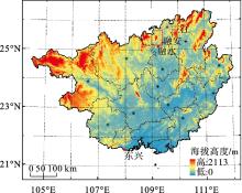
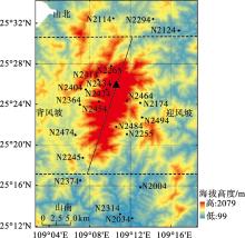
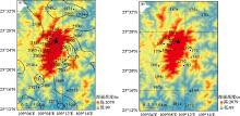
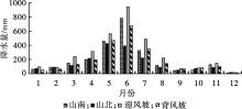
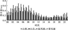
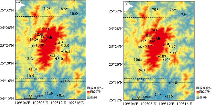
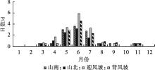
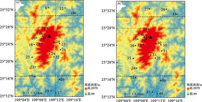
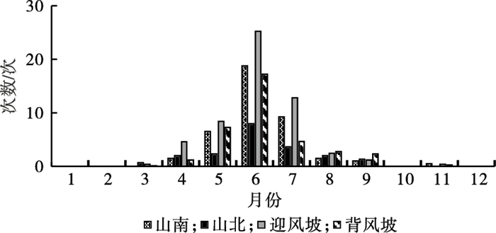
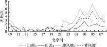
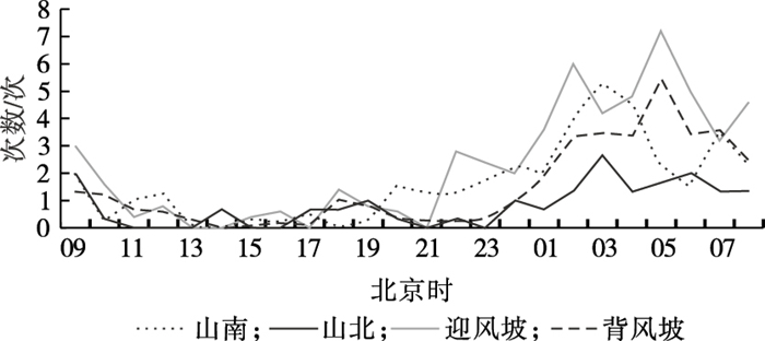
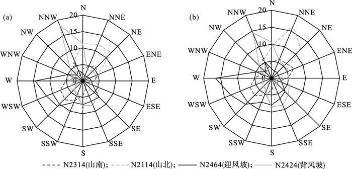
利用广西元宝山山地梯度气象观测系统21个区域自动气象站2021—2022年逐时降水量数据, 分析了元宝山及其周边地区的降水时空分布特征。结果表明: 元宝山年平均降水量接近2700 mm, 呈东高西低分布, 降水大值区集中在迎风坡, 迎风坡年降水量比背风坡多近900 mm; 降水日数随海拔升高而增加; 月降水量呈单峰特征, 5—7月为降水集中期, 在山南、迎风坡和背风坡6月降水量最大, 占全年降水28%以上, 山北则是5月最大; 日降水峰值主要发生在凌晨04—05时, 白天降水不活跃, 16—17时达到谷值。元宝山上年暴雨日数为9.5~18.5 d, 主要出现在5—7月, 4个区域暴雨日数最大值均出现在6月; 高海拔区域暴雨日数多于低海拔区域; 迎风坡和山南暴雨强度明显大于其他区域。元宝山上出现短时强降水次数每年为10~32次; 山上和山下各区域短时强降水的开始、结束月份和持续时间均有较大差异; 短时强降水集中发生在凌晨, 且随海拔高度升高而略有推迟, 发生最多的区域是迎风坡; 各区域的短时强降水强度相差不大, 均为30 mm·h-1左右。

关键词: 梯度观测, 地形, 逐时降水

Abstract:

In order to further understand the influence of Yuanbao Mountain on rainfall in northeast of Guangxi Zhuang Autonomous Region, the spatial and temporal distribution characteristics of precipitation in Yuanbao Mountain and its surrounding areas were analyzed based on the hourly observation data from 2021 to 2022 of the Guangxi Yuanbao Mountain gradient meteorological observation system, which consists of 21 regional automatic meteorological stations. The results indicate that the average annual precipitation in Yuanbao Mountain is nearly 2700 mm, which is comparable to that in the coastal areas of Guangxi. It is distributed from high in the east to low in the west, with large precipitation values concentrated on the windward slope. The annual precipitation on the windward and leeward slopes differs by nearly 900 mm. The number of precipitation days increases with altitude. Monthly precipitation has a single peak, with most precipitation occurring from May to July. In the southern regions, the maximum monthly precipitation occurs in June on windward and leeward slopes of Yuanbao Mountain, accounting for more than 28% of the annual precipitation, and the maximum monthly precipitation in the northern regions occurs in May. The peak daily rainfall mainly occurs at 04-05 am, with little rainfall activity during the daytime, reaching a minimum at 16-17 pm. In addition, the number of annual heavy rain days in Yuanbao Mountain ranges from 9.5 to 18.5 days, mainly occurring from May to July. The maximum number of heavy rain days occurs in June in all regions. The number of heavy rain days in high altitude regions is higher than that in low altitude regions. The intensity of heavy rain on the windward slope and southern slopes of the mountain is significantly greater than that in other regions. Moreover, the frequency of short-term heavy rain in Yuanbao Mountain is 10~32 times per year. There are significant differences in the starting and ending months and the duration of short-term heavy rain in different regions. Short-term heavy rain mainly occurs in the early morning, but it is slightly delayed with increasing altitude. Short-term heavy rain occurs most frequent on the windward slope, and the intensity of short-term heavy rain is similar in different regions.

Key words: Gradient observation, Topography, Hourly rain

中图分类号: