主办单位:中国气象局沈阳大气环境研究所
国际刊号:ISSN 1673-503X
国内刊号:CN 21-1531/P
国际刊号:ISSN 1673-503X
国内刊号:CN 21-1531/P
Journal of Meteorology and Environment ›› 2022, Vol. 38 ›› Issue (4): 1-10.doi: 10.3969/j.issn.1673-503X.2022.04.001
Previous Articles Next Articles
Yun-xia DUAN1,2( ),De-qin LI2,*(),Yong-ming JI3,Wei-long BAN1,Yu-tong WU2,Xiao-ou LI1
Received:2021-04-03
Online:2022-08-28
Published:2022-09-22
Contact:
De-qin LI
E-mail:yxduan@163.com;Lewen05@hotmail.com
CLC Number:
Yun-xia DUAN, De-qin LI, Yong-ming JI, Wei-long BAN, Yu-tong WU, Xiao-ou LI. Analysis of strong precipitation in the urban area of Shenyang under the Northeast Cold Vortex background[J]. Journal of Meteorology and Environment, 2022, 38(4): 1-10.
Fig.1
Distributions of accumulated precipitation during 15:00-23:00 (a) and temperature at 15:00 (b) on June 30, 2016, observed with the automatic weather stations in Liaoning province"
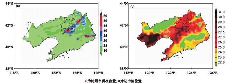
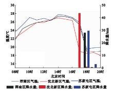
Fig.2
Time series of hourly rainfall and temperature during 08:00-20:00 on June 30, 2016, at the automatic weather stations of Hunnan, Shenbei, Sujiatun weather stations"
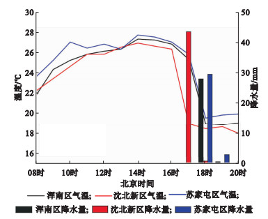
Fig.3
Synoptic chart of 500 hPa geopotential height, 850 hPa temperature, wind, and specific humidity fields at 14:00 (a)、17:00 (c), 20:00 (c), and 23:00 (d) on June 30, 2016"
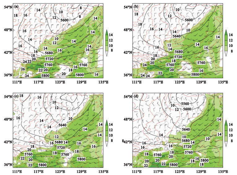
Fig.4
T-logP diagrams of temperature and dew point temperature at Hunnan sounding station at 08:00(a) and 20:00(b) on June 30, 2016"
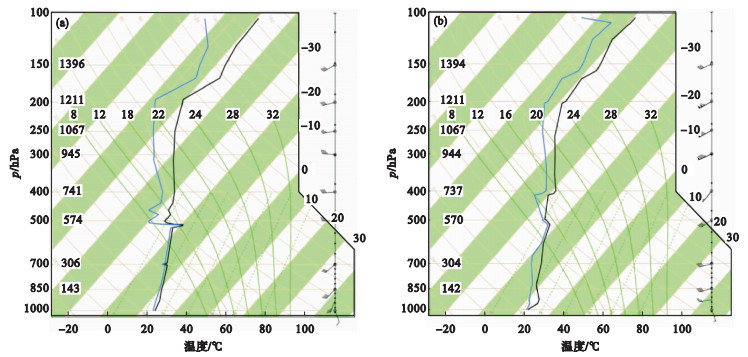
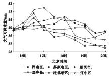
Fig.5
Time series of precipitable water vapor during 15:30-20:00 on June 30, 2016 in Shenyang area"

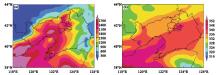
Fig.6
Spatial distributions of convective available potential energy (a) and pseudo-equivalent potential temperature (b) at 15:00 on June 30, 2016, in Liaoning province"
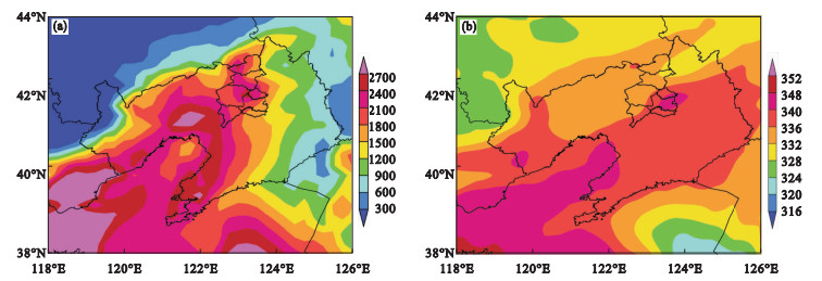
Fig.7
Time-height cross sections of vorticity and divergence(a), pseudo-equivalent potential temperature and vertical velocity (b), wind and specific humidity (c) during 08:00-23:00 on June 30, 2016, in urban areas of Shenyang (123.3°E, 41.8°N)"
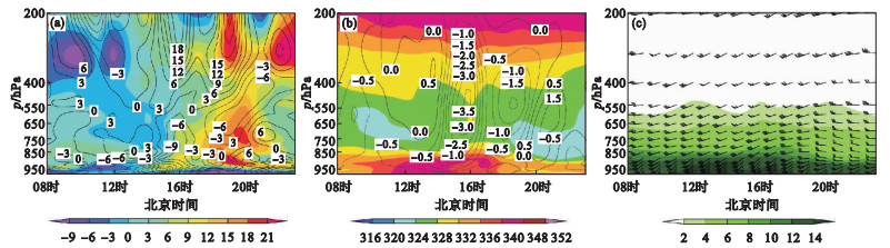
Fig.8
The 10 m wind and hourly precipitation at 16:00(a)、17:00(b)、18:00(c) and 19:00(d) on June 30, 2016, in Shenyang areas"

Fig.9
Doppler Radar composite reflectivity at 16:30 (a), 17:00 (b), 17:30 (c) and 18:00 (d) on June 30, 2016, in Liaoning province"
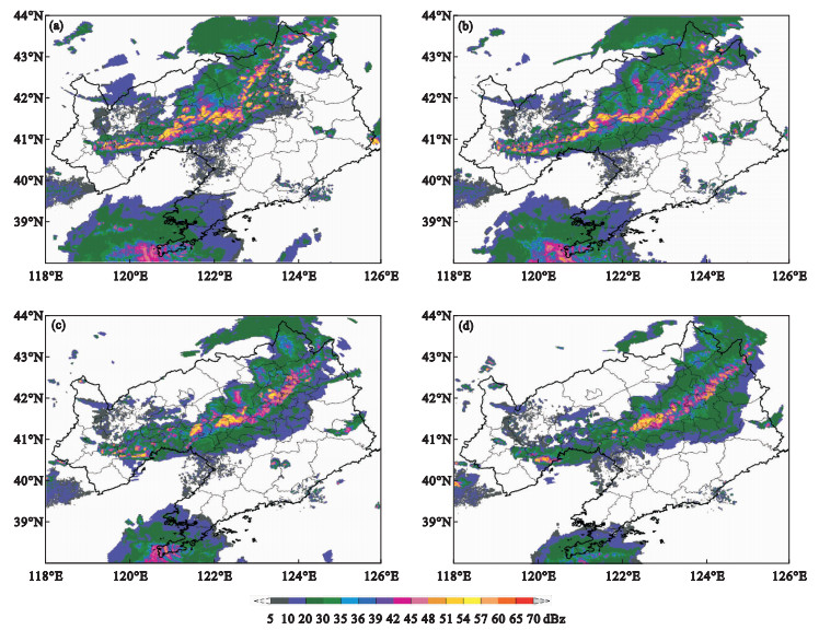
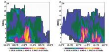
Fig.10
Vertical sections of Doppler Radar composite reflectivity at zero kilometer pumping station at 16:48 on June 30, 2016"
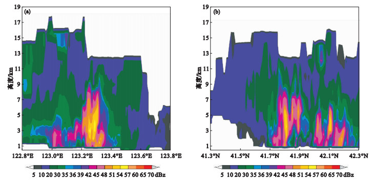
Fig.11
Comparisons of the 12-h cumulative precipitation during 08:00-20:00 on June 30 (a) and the forecasting precipitation by the ECMWF global model from 20:00 on June 28 (b) and 20:00 on June 29, 2016 (c), in Liaoning province"
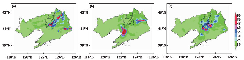
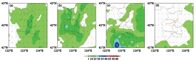
Fig.12
The 10 m wind barb and 3-hour accumulative precipitation at 14:00 (a), 17:00 (b), 20:00 (c) and 23:00 (d) on June 30, 2016, in Shenyang areas"
| 1 |
肖光梁, 陈传雷, 龙晓慧, 等. 辽宁省短时暴雨和大暴雨时空分布与变化特征[J]. 气象与环境学报, 2019, 35 (5): 46- 52.
doi: 10.3969/j.issn.1673-503X.2019.05.006 |
| 2 | 寿亦萱, 张大林. 城市热岛效应的研究进展与展望[J]. 气象学报, 2012, 70 (3): 338- 353. |
| 3 |
孙继松, 舒文军. 北京城市热岛效应对冬夏季降水的影响研究[J]. 大气科学, 2007, 31 (2): 311- 320.
doi: 10.3878/j.issn.1006-9895.2007.02.12 |
| 4 |
王丛梅, 吴智杰, 刘瑾, 等. 城市短时强降雨中尺度观测特征分析[J]. 气象科技, 2011, 39 (6): 678- 684.
doi: 10.3969/j.issn.1671-6345.2011.06.002 |
| 5 | 沈澄, 颜廷柏, 刘冬晴, 等. 2008—2012年南京短时强降水特征分析[J]. 气象与环境学报, 2015, 31 (1): 28- 33. |
| 6 |
Rosenfeld D . Suppression of rain and snow by urban and industrial air pollution[J]. Science, 2000, 287 (5459): 1793- 1796.
doi: 10.1126/science.287.5459.1793 |
| 7 |
冯晋勤, 汤达章, 曹长尧. 福建西部山区短时暴雨雷达回波特征及中小尺度系统分析[J]. 气象, 2014, 40 (3): 297- 304.
doi: 10.3969/j.issn.1674-7097.2014.03.006 |
| 8 | 蔡雪薇, 谌芸, 沈新勇, 等. 冷涡背景下不同类型强对流天气的成因对比分析[J]. 气象, 2019, 45 (5): 621- 631. |
| 9 | 卢焕珍, 孙晓磊, 刘一玮, 等. 一次分散性暴雨中尺度对流系统发展特征[J]. 干旱气象, 2018, 36 (4): 667- 675. |
| 10 | 覃武, 刘国忠, 赖珍权, 等. 华南暖区暴雨预报失误及可预报性探讨[J]. 气象, 2020, 46 (8): 1039- 1052. |
| 11 |
徐珺, 杨舒楠, 孙军, 等. 北方一次暖区大暴雨强降水成因探讨[J]. 气象, 2014, 40 (12): 1455- 1463.
doi: 10.7519/j.issn.1000-0526.2014.12.004 |
| 12 | 谌芸, 吕伟绮, 于超, 等. 北方一次暖区大暴雨降水预报失败案例剖析[J]. 气象, 2018, 44 (1): 15- 25. |
| 13 |
王秀娟, 姜忠宝, 马晓华, 等. 2018年吉林省一次暴雨过程成因分析[J]. 气象与环境学报, 2020, 36 (2): 1- 8.
doi: 10.3969/j.issn.1673-503X.2020.02.001 |
| 14 | 李强, 王秀明, 张亚萍, 等. 一次副高影响下的局地强风暴触发及维持机制探析[J]. 气象, 2019, 45 (2): 203- 215. |
| 15 | 沈杭锋, 陈光宇, 金成, 等. 浙江北部一次短时大暴雨的中尺度分析[J]. 气象科技, 2017, 45 (3): 508- 515. |
| 16 | 杨磊, 蒋大凯, 王瀛, 等. 辽宁省汛期GPS大气可降水量的特征分析[J]. 干旱气象, 2016, 34 (1): 82- 87. |
| 17 | 雷蕾, 邢楠, 周璇, 等. 2018年北京"7·16"暖区特大暴雨特征及形成机制研究[J]. 气象学报, 2020, 78 (1): 1- 17. |
| 18 | 俞小鼎. 2012年7月21日北京特大暴雨成因分析[J]. 气象, 2012, 38 (11): 1313- 1329. |
| 19 | 孙继松, 雷蕾, 于波, 等. 近10年北京地区极端暴雨事件的基本特征[J]. 气象学报, 2015, 73 (4): 609- 623. |
| 20 | 郑永光, 陶祖钰, 俞小鼎. 强对流天气预报的一些基本问题[J]. 气象, 2017, 43 (6): 641- 652. |
| 21 | 陈传雷, 管兆勇, 纪永明, 等. 辽宁长历时暴雨中尺度对流系统特征分析[J]. 气象, 2018, 44 (8): 1051- 1062. |
| 22 | 曹艳察, 郑永光, 盛杰, 等. 2018年7月15—17日北京极端强降水过程三类对流风暴及其强降水特征分析[J]. 气象, 2020, 46 (7): 885- 897. |
| [1] | Yue YU, Ming-lin BI, Qi YAN, Hai-feng LIN, Dong-lei FENG, Fan-yue YU. Cause analysis and spatial test of multi-mode numerical prediction on regional rainstorms in Liaoning province [J]. Journal of Meteorology and Environment, 2022, 38(4): 11-18. |
| [2] | Hui-meng BAO,Da-feng GUO,Wei LI. Correction tests of ECMWF modeling quantitative precipitation using frequency matching method in Jiangxi provice [J]. Journal of Meteorology and Environment, 2022, 38(2): 12-20. |
| [3] | Qi XUE,Ya-ping TANG,Li-na WANG,Hai-feng GUO,Hui ZHAO,Peng-cheng MA. Spatiotemporal distribution of short-term heavy precipitation and characteristics of synoptic condition during summer in Pingliang, Gansu province from 2015 to 2019 [J]. Journal of Meteorology and Environment, 2022, 38(1): 57-64. |
| [4] | Yao HUANG,Jia-xing YOU,Tian-gui XIAO,Jie GUO. Effects of low-frequency oscillation on the persistent extreme precipitation in Western Sichuan [J]. Journal of Meteorology and Environment, 2021, 37(3): 47-56. |
| [5] | ZHENG Shi, WANG Guan, LIN Zhong-guan, GUAN Jian-hua, HUANG Xing-you. Characteristics analysis of heavy precipitation in China from 1961 to 2013 [J]. Journal of Meteorology and Environment, 2018, 34(6): 102-107. |
| [6] | LIU Lei, ZHOU Jing, LIU Jun-jie, GAO Hui. Decadal characteristics of persistent heavy precipitation in the middle and lower reaches of the Yangtze River and its circulation pattern [J]. Journal of Meteorology and Environment, 2018, 34(3): 28-36. |
| [7] | ZHANG Duan-yu, CUI Chun-guang, XU Ming, WANG Jing-yu, HU Chang-qiong. Analysis of the evolution of convective clouds during a rainstorm in 2015 over Hubei province [J]. Journal of Meteorology and Environment, 2017, 33(2): 8-17. |
| [8] | SHEN Cheng,YAN Ting-bai,LIU Dong-qing,LI Jing2. Characteristics of short-time heavy precipitation from 2008 to 2012 in Nanjing [J]. Journal of Meteorology and Environment, 2015, 31(1): 28-33. |
| [9] | ZHANG Xi-ying,XU Yue. Evolution feature of mecoscale convective system (MCS) in a summer low vortex system [J]. Journal of Meteorology and Environment, 2013, 29(2): 1-5. |
| [10] | SU Ai-fang,LIANG Jun-pin,CUI Li-man,LIU Chao. Warning characteristic and trigger mechanism of a local strong hailstorm in northern He’nan province [J]. Journal of Meteorology and Environment, 2012, 28(6): 1-7. |
| [11] | ZHAO Jun-rong. Analysis of meso-micro scale system in a?rare heavy rain on the?northern slope of Tianshan Mountain [J]. Journal of Meteorology and Environment, 2012, 28(6): 19-24. |
| [12] | MA Hong-Qing, DING Zhi-Ying, ZHANG Hui, WANG Zhi-Chao. Analysis of formation reasons of spring rainstorm in May 2009 over the middle and south of Hebei province [J]. Journal of Meteorology and Environment, 2011, 27(5): 32-37. |
| [13] | CHEN Chuan-lei;WU Xiao-feng;SUN Xiao-wei;WANG Ying;WANG Tai-wei;WEI Xiao-lin. Climatic characteristics of severe convective weather in Liaoning province [J]. Journal of Meteorology and Environment, 2010, 26(3): 27-33. |
| Viewed | ||||||
|
Full text |
|
|||||
|
Abstract |
|
|||||
|