| 1 |
张海东, 罗勇, 王邦中, 等. 气象灾害和气候变化对国家安全的影响[J]. 气候变化研究进展, 2006, 2 (2): 85- 88.
|
| 2 |
Frich P , Alexander L V , Della-marta P , et al. Observed coherent changes in climatic extremes during the second half of the twentieth century[J]. Climate Research, 2002, 19 (3): 193- 212.
|
| 3 |
黄荣辉, 杜振彩. 全球变暖背景下中国旱涝气候灾害的演变特征及趋势[J]. 自然杂志, 2010, 32 (4): 187- 195.
|
| 4 |
IPCC.Managing the risks of extreme events and disasters to advance climate change adaptation[M]//Field C B, Barros V, Stocker T F, et al.A special report of Working Groups I and Ⅱ of the Intergovernmental Panel on Climate Change.New York: Cambridge University Press, 2012.
|
| 5 |
姚玉璧, 张强, 李耀辉, 等. 干旱灾害风险评估技术及其科学问题与展望[J]. 资源科学, 2013, 35 (9): 1884- 1897.
|
| 6 |
朱丽娟, 吴焕, 孟雪靖. 黑龙江省农业自然灾害及其影响分析[J]. 广东农业科学, 2012, 39 (4): 209- 211.
|
| 7 |
姜丽霞, 陈可心, 刘丹, 等. 2013年黑龙江省主汛期降水异常特征及其对作物产量影响的分析[J]. 气象, 2015, 41 (1): 105- 112.
|
| 8 |
刘琳, 徐宗学. 西南地区旱涝特征及其趋势预测[J]. 自然资源学报, 2014, 29 (10): 1792- 1801.
|
| 9 |
刘佳旭, 李丽娟, 李九一, 等. 1954-2014年云南省降水变化特征与潜在的旱涝区域响应[J]. 地球信息科学学报, 2016, 18 (8): 1077- 1086.
|
| 10 |
茅海祥, 王文. 1960-2010年中国南方地区夏季旱涝时空分布特征[J]. 气象与环境学报, 2012, 28 (1): 90- 95.
|
| 11 |
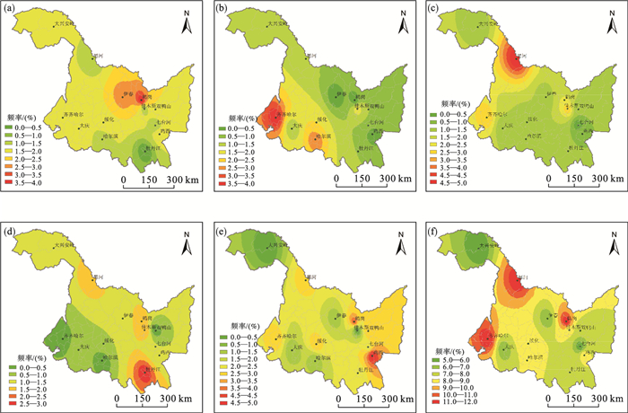
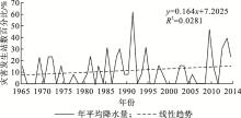
杨晓静, 徐宗学, 左德鹏, 等. 东北三省近55a旱涝时空演变特征[J]. 自然灾害学报, 2016, 25 (4): 9- 19.
|
| 12 |
韩冬梅, 杨贵羽, 严登华, 等. 近50年东北地区旱涝时空特征分析[J]. 水电能源科学, 2014, 32 (6): 5- 8.
|
| 13 |
顾金普, 王双银, 龚家国, 等. 黑龙江省降水及旱涝时空演变特征[J]. 水电能源科学, 2017, 35 (2): 17- 20.
|
| 14 |
王学哲, 孙才志, 曹永强. 基于修正Z指数的黑龙江省旱涝时空特性分析[J]. 水电能源科学, 2017, 35 (10): 1- 4.
|
| 15 |
高璐迪.近50年黑龙江省农业界限温度及地表温度时空变化特征分析[D].哈尔滨:东北农业大学, 2016.
|
| 16 |
孙彦坤, 李浩然, 兰倩, 等. 黑龙江省热量资源变化特征及对水稻不同发育期生长的影响[J]. 南方农业学报, 2018, 49 (9): 1794- 1803.
|
| 17 |
杜绍敏. 黑龙江省水资源特征与可持续利用对策[J]. 黑龙江水专学报, 2005, 32 (4): 96- 99.
|
| 18 |
王劲松, 郭江勇, 周跃武, 等. 干旱指标研究的进展与展望[J]. 干旱区地理, 2007, 30 (1): 60- 65.
|
| 19 |
Vergni L , Todisco F . Spatio-temporal variability of precipitation, temperature and agricultural drought indices in Central Italy[J]. Agricultural and Forest Meteorology, 2011, 151 (3): 301- 313.
|
| 20 |
Ezzine H , Bouziane A , Ouazar D . Seasonal comparisons of meteorological and agricultural drought indices in Morocco using open short time-series data[J]. International Journal of Applied Earth Observations and Geoinformation, 2014, 26, 36- 48.
|
| 21 |
郭小芹, 罗永忠. 1961-2016年祁连山区季节性干旱综合指数特征分析[J]. 气象与环境学报, 2019, 35 (1): 88- 93.
|
| 22 |
庄晓翠, 郭城, 张林梅. 西北干旱区阿勒泰地区气温日较差的变化特征及R/S分析[J]. 干旱区资源与环境, 2010, 24 (12): 85- 92.
|
| 23 |
迟道才, 张欣雅, 陈涛涛, 等. 基于标准化降水指数的干旱变化特征分析——以大庆地区为例[J]. 沈阳农业大学学报, 2018, 49 (2): 173- 179.
|
| 24 |
杨世刚, 杨德保, 赵桂香, 等. 三种干旱指数在山西省干旱分析中的比较[J]. 高原气象, 2011, 30 (5): 1406- 1414.
|
| 25 |
鞠笑生, 杨贤为, 陈丽娟, 等. 我国单站旱涝指标确定和区域旱涝级别划分的研究[J]. 应用气象学报, 1997, 8 (1): 26- 33.
|
| 26 |
张存杰, 王宝灵, 刘德祥, 等. 西北地区旱涝指标的研究[J]. 高原气象, 1998, 17 (4): 381- 389.
|
| 27 |
刘剑刚. 基于Z指数的辽宁省洪涝灾害时空分析[J]. 沈阳师范大学学报:自然科学版, 2012, 30 (3): 409- 413.
|
| 28 |
袁文平, 周广胜. 标准化降水指标与Z指数在我国应用的对比分析[J]. 植物生态学报, 2004, 28 (4): 523- 529.
|
| 29 |
蔡敏, 黄艳, 朱宵峰, 等. Z指数方法在小流域洪涝灾害预警技术研究中的应用[J]. 气象科技, 2010, 38 (4): 418- 422.
|
| 30 |
李柏贞, 周广胜. 干旱指标研究进展[J]. 生态学报, 2014, 34 (5): 1043- 1052.
|
| 31 |
曹义娜.黑龙江省洪涝灾害分布特征及其对玉米产量的影响[D].哈尔滨:东北农业大学, 2017.
|
| 32 |
唐亚平, 张凯, 李忠娴, 等. 1964-2008年辽宁省旱涝时空分布特征及演变趋势[J]. 气象与环境学报, 2011, 27 (2): 50- 55.
|
| 33 |
袁媛, 王心源, 雷能忠, 等. 基于GIS的江淮分水岭地区旱涝灾害时空分析[J]. 水文, 2007, 27 (6): 36- 38, 49.
|
| 34 |
邓晓斌. 基于ArcGIS两种空间插值方法的比较[J]. 地理空间信息, 2008, 6 (6): 85- 87.
|
| 35 |
刘志雄, 肖莺. 长江上游旱涝指标及其变化特征分析[J]. 长江流域资源与环境, 2012, 21 (3): 310- 314.
|
| 36 |
张娜, 陈莹, 张粮锋, 等. 基于Z指数的福州市近51年旱涝时空特征分析[J]. 海南师范大学学报:自然科学版, 2015, 28 (3): 292- 297.
|
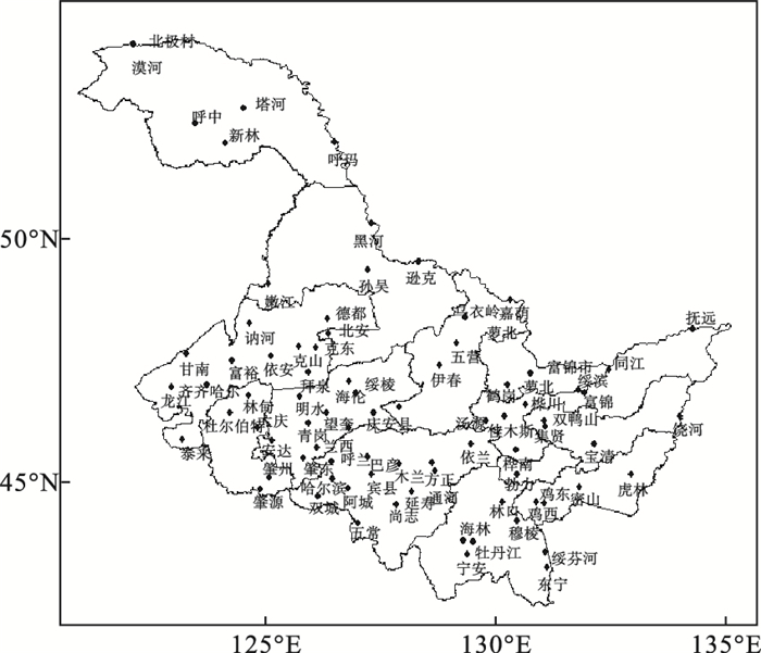
 ),周永吉2,姜丽霞3,曹义娜1,郭立峰3,*(