| 1 |
Fujita T T. Proposed mechanism of suction spots accompanied by tornadoes[C]// American Meteorological Society. Preprints, 7th Conference on Severe Local Storms. Kansas City, MO, USA: American Meteorological Society, 1971: 208-213.
|
| 2 |
McDonald J R.T . Theodore Fujita: His contribution to tornado knowledge through damage documentation and the Fujita scale[J]. Bulletin of the American Meteorological Society, 2001, 82 (1): 63- 72.
doi: 10.1175/1520-0477(2001)000<0063:TTFHCT>2.3.CO;2
|
| 3 |
Straka J M , Rasmussen E N , Fredrickson S E . A mobile mesonet for finescale meteorological observations[J]. Journal of Atmospheric and Oceanic Technology, 1996, 13 (5): 921- 936.
doi: 10.1175/1520-0426(1996)013<0921:AMMFFM>2.0.CO;2
|
| 4 |
范雯杰, 俞小鼎. 中国龙卷的时空分布特征[J]. 气象, 2015, 41 (7): 793- 805.
|
| 5 |
王霁吟. 中国龙卷特征及其潜势预报之初探[D]. 南京: 南京大学, 2014: 11-14.
|
| 6 |
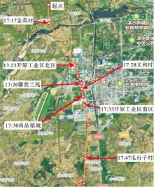
王秀明, 俞小鼎, 周小刚. 中国东北龙卷研究: 环境特征分析[J]. 气象学报, 2015, 73 (3): 425- 441.
|
| 7 |
朱红蕊, 张洪玲, 孙爽, 等. 1956—2011年黑龙江省龙卷风气候特征[J]. 气象与环境学报, 2015, 31 (3): 98- 103.
|
| 8 |
俞小鼎, 郑媛媛, 张爱民, 等. 安徽一次强烈龙卷的多普勒天气雷达分析[J]. 高原气象, 2006, 25 (5): 914- 924.
doi: 10.3321/j.issn:1000-0534.2006.05.020
|
| 9 |
张晰莹, 吴迎旭, 张礼宝. 利用卫星、雷达资料分析龙卷发生的环境条件[J]. 气象, 2013, 39 (6): 728- 737.
|
| 10 |
王婷婷, 王宁, 姚瑶, 等. 东北冷涡背景下两类龙卷形成机制的对比分析[J]. 气象与环境学报, 2017, 33 (6): 9- 15.
doi: 10.3969/j.issn.1673-503X.2017.06.002
|
| 11 |
吴迎旭, 周一, 刘松涛, 等. 一次引发黑龙江省大风与强降水的β中尺度系统物理机制与特征分析[J]. 气象与环境学报, 2016, 32 (3): 1- 9.
doi: 10.3969/j.issn.1673-503X.2016.03.001
|
| 12 |
植江玲. "艾云尼"台风龙卷天气过程分析[J]. 气象与环境学报, 2020, 36 (2): 20- 27.
doi: 10.3969/j.issn.1673-503X.2020.02.003
|
| 13 |
孙继松, 陶祖钰. 强对流天气分析与预报中的若干基本问题[J]. 气象, 2012, 38 (2): 164- 173.
|
| 14 |
张小玲, 杨波, 朱文剑, 等. 2016年6月23日江苏阜宁EF4级龙卷天气分析[J]. 气象, 2016, 42 (11): 1304- 1314.
doi: 10.7519/j.issn.1000-0526.2016.11.002
|
| 15 |
Schumacher R S , Lindsey D T , Schumacher A B , at al . Multidisciplinary analysis of an unusual tornado: Meteorology, climatology, and the communication and interpretation of warnings[J]. Weather and Forecasting, 2010, 25 (5): 1412- 1429.
doi: 10.1175/2010WAF2222396.1
|
| 16 |
Arsen S A . Mathematical modeling of tornadoes and squall storms[J]. Geoscience Frontiers, 2011, 2 (2): 215- 221.
doi: 10.1016/j.gsf.2011.03.007
|
| 17 |
Doswell C A , Carbin G W , Brooks H E . The tornadoes of spring 2011 in the USA: an historical perspective[J]. Weather, 2012, 67 (4): 88- 94.
doi: 10.1002/wea.1902
|
| 18 |
张涛, 关良, 郑永光, 等. 2019年7月3日辽宁开原龙卷灾害现场调查及其所揭示的龙卷演变过程[J]. 气象, 2020, 46 (5): 603- 617.
|
| 19 |
郑永光, 蓝渝, 曹艳察, 等. 2019年7月3日辽宁开原EF4级强龙卷形成条件、演变特征和机理[J]. 气象, 2020, 46 (5): 589- 602.
|
| 20 |
Bluestein H B , Weiss C C , French M M , et al. The structure of tornadoes near Attica, Kansas, on 12 May 2004:high-resolution, mobile, Doppler radar observations[J]. Monthly Weather Review, 2007, 135 (2): 475- 506.
doi: 10.1175/MWR3295.1
|
| 21 |
Markowski P M , Richardson Y P . The influence of environmental low-level shear and cold pools on tornadogenesis: insights from idealized simulations[J]. Journal of the Atmospheric Sciences, 2014, 71 (1): 243- 275.
doi: 10.1175/JAS-D-13-0159.1
|
| 22 |
姚聃. 龙卷数值模拟研究进展[J]. 气象科技进展, 2018, 8 (2): 28- 35.
|
| 23 |
Thompson R L, Edwards R, Hart J A. An assessment of supercell and tornado forecast parameters with RUC-2 model close proximity soundings[C]//American Meteorological Society. Preprints, 21st Conference On Severe Local Storm. San Antonio, TX, USA: American Meteorological Society, 2002: 595-598.
|
| 24 |
徐小红, 余兴, 朱延年, 等. 6.23龙卷FY-2G卫星云微物理特征分析[J]. 高原气象, 2018, 37 (6): 1737- 1748.
|
| 25 |
俞小鼎, 姚秀萍, 熊廷南, 等. 多普勒天气雷达原理与业务应用[M]. 北京: 气象出版社, 2007: 90- 129.
|
| 26 |
徐璐璐, 李倩, 李慧琳, 等. 2018年9月丹东连续两次风雹天气的多尺度对比分析[J]. 气象与环境学报, 2019, 35 (6): 1- 7.
|
| 27 |
Lee B D , Jeweet B F , Wilhelmson R B . The 19 April 1996 Illinois tornado outbreak.Part Ⅰ: cell evolution and supercell isolation[J]. Weather and Forecasting, 2006, 21 (4): 433- 448.
doi: 10.1175/WAF944.1
|
| 28 |
朱君鉴, 王令, 黄秀韶, 等. CINRAD/SA中气旋产品与强对流天气[J]. 气象, 2005, 31 (2): 38- 42.
|
| 29 |
方翀, 郑媛媛. 新一代天气雷达中气旋产品特征值统计和个例分析[J]. 气象, 2007, 33 (11): 16- 20.
|
| 30 |
陈传雷, 吴晓峰, 孙晓巍, 等. 辽宁省强对流性天气的气候特征分析[J]. 气象与环境学报, 2010, 26 (3): 27- 33.
|
| 31 |
张培昌, 朱君鉴, 魏鸣, 等. 龙卷形成原理与天气雷达探测[M]. 北京: 气象出版社, 2019: 30- 50.
|
 ),李得勤2,冯呈呈1,张立鹏1