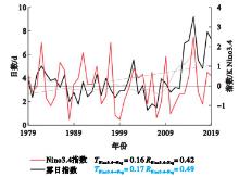
| 1 |
中国气象局. 地面气象观测规范[M]. 北京: 气象出版社, 2003: 21- 27.
|
| 2 |
周述学, 邓学良, 王传辉, 等. 华东2018年冬季一次典型雾霾过程的气象成因分析[J]. 高原气象, 2020, 39 (5): 1110- 1121.
|
| 3 |
王丽萍, 陈少勇, 董安祥. 中国雾区的分布及其季节变化[J]. 地理学报, 2005, 60 (4): 689- 697.
doi: 10.3321/j.issn:0375-5444.2005.04.018
|
| 4 |
史军, 崔林丽, 贺千山, 等. 华东雾和霾日数的变化特征及成因分析[J]. 地理学报, 2010, 65 (5): 533- 542.
|
| 5 |
Liu W J , Han Y X , Li J X , et al. Factors affecting relative humidity and its relationship with the long-term variation of fog-haze events in the Yangtze River Delta[J]. Atmospheric Environment, 2018, 93, 242- 250.
|
| 6 |
伍红雨, 杜尧东, 何健, 等. 华南霾日和雾日的气候特征及变化[J]. 气象, 2011, 37 (5): 607- 614.
|
| 7 |
孔锋. 1961-2016年中国雾与霾日数时空演变特征及区域差异研究[J]. 灾害学, 2020, 35 (1): 131- 137.
doi: 10.3969/j.issn.1000-811X.2020.01.024
|
| 8 |
齐庆华. 中国东部海陆热力差异与华南冬季雾霾的气候学关联[J]. 地理科学, 2021, 41 (9): 1667- 1675.
|
| 9 |
郑凤琴, 周绍毅, 韦晶晶, 等. 北部湾海雾特点及海陆大雾差异分析[J]. 气象科技, 2020, 48 (5): 717- 722.
|
| 10 |
郑凤琴, 罗小莉, 钟利华, 等. 北部湾地区海雾特点的初步分析[J]. 应用海洋学学报, 2021, 40 (2): 324- 331.
|
| 11 |
Hu S Q , Zhang W J , Turner A G , et al. How does El Niño-Southern Oscillation affect winter fog frequency over eastern China?[J]. Climate Dynamics, 2020, 54 (1): 1043- 1056.
|
| 12 |
Zhang R H , Sumi A , Kimoto M . A diagnostic study of the impact of El Niño on the precipitation in China[J]. Advances in Atmospheric Sciences, 1999, 16 (2): 229- 241.
doi: 10.1007/BF02973084
|
| 13 |
Wang Y F , Fujiyoshi Y . A case study on the relationship between a preceding La Niña event and East Asian summer atmospheric circulation[J]. Acta Meteorologica Sinica, 2004, 18 (4): 387- 396.
|
| 14 |
Fan L L , Xu J J , Li J J . Differences in pre-flood season rainfall in South China between spring and summer El Niño events[J]. Atmosphere-ocean, 2020, 58 (24): 1- 13.
|
| 15 |
郑凤琴, 曾鹏, 罗小莉, 等. 广西区域霾过程高低空大气环流型影响分析[J]. 气象科技, 2019, 47 (4): 655- 662.
|
| 16 |
张璐, 刘鹏, 张文君, 等. 中国不同区域气候条件对冬季雾日形成的差异性分析[J]. 气候与环境研究, 2019, 24 (5): 585- 596.
|
| 17 |
植炫惠, 徐海明, 马静, 等. 华南冬季雾日年际变化特征及其与ENSO的关系[J]. 大气科学, 2023, 47 (4): 1099- 1112.
|
| 18 |
覃皓, 郭栋, 施春华, 等. 南亚高压与邻近地区臭氧变化的相互作用[J]. 大气科学, 2018, 42 (2): 14.
|
| 19 |
覃皓, 伍丽泉, 何慧. 广西前汛期降水变化特征及其与东南太平洋海温变化的因果联系[J]. 热带气象学报, 2022, 38 (2): 265- 274.
|
| 20 |
Liang X S . Unraveling the cause-effect relation between time series[J]. Physical Review E, 2014, 90 (5-1): 052150.
|
| 21 |
宫湛秋, 孙诚, 李建平, 等. 基于信息流理论的因果分析在辨析大西洋多年代际振荡物理机制中的应用[J]. 大气科学, 2019, 43 (5): 1081- 1094.
|
| 22 |
Liang X S . Information flow within stochastic dynamical systems[J]. Physical Review E, 2008, 78 (3): 031113.
doi: 10.1103/PhysRevE.78.031113
|
| 23 |
Liang X S . The Liang-Kleeman information flow: Theory and applications[J]. Entropy, 2013, 15 (1): 327- 360.
doi: 10.3390/e15010327
|
| 24 |
Liang X S , Xu F , Rong Y N , et al. El Niño Modoki can be mostly predicted more than 10 years ahead of time[J]. Scientific Reports, 2021, 11, 17860.
doi: 10.1038/s41598-021-97111-y
|
| 25 |
覃皓, 伍丽泉, 何慧. 夏季热带大西洋海温变化对华南前汛期降水的影响[J]. 大气科学, 2023, 47 (5): 1309- 1324.
|
| 26 |
覃皓. 北太平洋海温与广西前汛期降水的联系[J]. 地球物理学报, 2023, 66 (3): 905- 919.
|
| 27 |
覃皓, 郑凤琴, 伍丽泉. 台风威马逊(1409)强度与降水变化的相互作用[J]. 应用气象学报, 2022, 33 (4): 477- 488.
|
| 28 |
Niu F , Li Z Q , Li C , et al. Increase of wintertime fog in China: Potential impacts of weakening of the eastern Asian monsoon circulation and increasing aerosol loading[J]. Journal of Geophysical Research Atmospheres, 2010, 115, D00K20.
|
| 29 |
Li Q , Zhang R H , Wang Y . Interannual variation of the wintertime fog-haze days across central and Eastern China and its relation with East Asian winter monsoon[J]. International Journal of Climatology, 2016, 36 (1): 346- 354.
doi: 10.1002/joc.4350
|
| 30 |
Li J P , Zheng F , Sun C , et al. Pathways of influence of the Northern Hemisphere mid-high latitudes on East Asian climate: a review[J]. Advances in Atmospheric Sciences, 2019, 36 (9): 902- 921.
doi: 10.1007/s00376-019-8236-5
|
| 31 |
Gill A E . Some simple solutions for heat-induced tropical circulation[J]. Quarterly Journal of the Royal Meteorological Society, 1980, 106 (449): 447- 462.
|
| 32 |
庞轶舒, 秦宁生, 王春学, 等. ENSO事件的季节演变对西南夏季降水异常的影响分析[J]. 高原气象, 2020, 39 (3): 581- 593.
|
| 33 |
吕文丽, 时晓曚, 张凯. 青岛地区一次雾—霾过程能见度特征及影响因素分析[J]. 气象与环境学报, 2023, 39 (3): 47- 55.
|
| 34 |
许敏, 李江波, 田晓飞, 等. 京津冀地区辐射雾生消影响因子和污染物特征分析[J]. 气象与环境学报, 2023, 39 (3): 56- 64.
|
| 35 |
李秀珍, 梁卫, 温之平. 华南秋、冬、春季水汽输送特征及其与降水异常的联系[J]. 热带气象学报, 2010, 26 (5): 626- 632.
|
| 36 |
阎琦, 李爽, 滕方达, 等. 2018年辽宁地区两次大雾天气成因分析[J]. 气象与环境学报, 2020, 36 (6): 91- 97.
|
| 37 |
李婷, 谭志强, 葛森, 等. 2018年8月22日宁夏北部局地浓雾天气形成机制分析[J]. 气象与环境学报, 2022, 38 (1): 8- 14.
|
| 38 |
张人禾, 李强, 张若楠, 等. 2013年1月中国东部持续性强雾霾天气产生的气象条件分析[J]. 中国科学: 地球科学, 2014, 44 (1): 27- 36.
|
| 39 |
旦增卓玛, 旺堆杰布, 桑秋璐, 等. 藏北一次局地爆发性浓雾特征与成因分析[J]. 气象与环境学报, 2021, 37 (5): 1- 7.
|
 ),郑凤琴2,*(