| 1 |
高松影, 赵婷婷, 宋丽丽, 等. 1949-2015年北上热带气旋特征[J]. 气象科技, 2017, 45 (2): 313- 323.
|
| 2 |
崔曜鹏, 杨磊, 孙丽, 等. 辽宁东南半岛两次北上台风暴雨特征及成因对比分析[J]. 气象与环境学报, 2022, 38 (2): 1- 11.
|
| 3 |
王东东, 孙丽, 杨磊, 等. 台风"巴威"不同类型降水多模式预报与空间检验对比评估[J]. 气象与环境学报, 2022, 38 (4): 37- 46.
|
| 4 |
梁军, 张胜军, 冯呈呈, 等. 台风Polly(9216)和Matmo(1410)对辽东半岛降水影响的对比分析[J]. 气象, 2019, 45 (6): 766- 776.
|
| 5 |
刘硕, 李得勤, 赛瀚, 等. 台风"狮子山"并入温带气旋过程及引发东北强降水的分析[J]. 高原气象, 2019, 38 (4): 804- 816.
|
| 6 |
孙密娜, 韩婷婷, 徐姝. 冷空气在北上台风"利奇马"致灾暴雨中的作用分析[J]. 自然灾害学报, 2021, 30 (1): 201- 212.
|
| 7 |
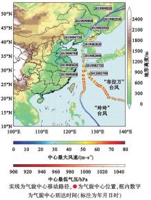
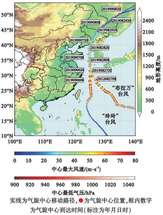
王宁, 马梁臣, 霍也. 一次爆发性气旋引发东北地区暴雨成因分析[J]. 气象与环境学报, 2022, 38 (3): 19- 28.
|
| 8 |
马梁臣, 孙力, 王宁. 东北地区典型暴雨个例的水汽输送特征分析[J]. 高原气象, 2017, 36 (4): 960- 970.
|
| 9 |
孙力, 马梁臣, 沈柏竹, 等. 2010年7-8月东北地区暴雨过程的水汽输送特征分析[J]. 大气科学, 2016, 40 (3): 630- 646.
|
| 10 |
吴国雄, 蔡雅萍, 唐晓菁. 湿位涡和倾斜涡度发展[J]. 气象学报, 1995, 53 (4): 387- 405.
|
| 11 |
朱男男, 刘彬贤, 孙密娜, 等. 引发渤海风暴潮一次江淮气旋北上过程诊断分析[J]. 气象与环境学报, 2016, 32 (5): 10- 17.
|
| 12 |
林小红, 吴建成, 刘通易, 等. 三个典型登闽空心结构台风强降水分布差异分析[J]. 气象与环境学报, 2019, 35 (1): 10- 17.
|
| 13 |
李静楠, 潘晓滨, 臧增亮, 等. 一次华北暴雨过程的湿位涡诊断分析[J]. 暴雨灾害, 2016, 35 (2): 158- 165.
|
| 14 |
王丛梅, 丁治英, 张金艳. 西北涡暴雨的湿位涡诊断分析[J]. 气象, 2005, 31 (11): 28- 33.
|
| 15 |
蒙伟光, 王安宇, 李江南, 等. 华南暴雨中尺度对流系统的形成及湿位涡分析[J]. 大气科学, 2004, 28 (3): 330- 341.
|
| 16 |
陈德花, 寿绍文, 张玲, 等. "碧利斯"引发强降水过程的湿位涡诊断分析[J]. 暴雨灾害, 2008, 27 (1): 37- 41.
|
| 17 |
刘峰, 丁治英, 梁艳, 等. "莫拉克"台风暴雨过程中湿位涡场的演变特征[J]. 暴雨灾害, 2011, 30 (2): 161- 166.
|
| 18 |
刘赛赛, 张立凤, 赵艳玲. 不同定义的湿位涡分析及在台风中的诊断[J]. 大气科学, 2019, 43 (3): 565- 576.
|
| 19 |
孙力, 董伟, 药明, 等. 1215号"布拉万"台风暴雨及降水非对称性分布的成因分析[J]. 气象学报, 2015, 73 (1): 36- 49.
|
| 20 |
任丽, 唐熠, 杨艳敏, 等. 两个相似路径台风深入内陆所致暴雨对比分析[J]. 暴雨灾害, 2021, 40 (5): 484- 493.
|
| 21 |
费建芳, 伍荣生, 宋金杰. 对称不稳定理论的天气分析与预报应用研究进展[J]. 南京大学学报(自然科学版), 2009, 45 (3): 323- 333.
|
| 22 |
吴国雄, 刘还珠. 全型垂直涡度倾向方程和倾斜涡度发展[J]. 气象学报, 1999, 57 (1): 1- 15.
|
| 23 |
吴国雄. 全型涡度方程和经典涡度方程比较[J]. 气象学报, 2001, 59 (4): 385- 392.
|
| 24 |
王宏, 寿绍文, 王万筠, 等. 一次局地暴雨过程的湿位涡诊断分析[J]. 自然灾害学报, 2009, 18 (3): 129- 134.
|
 ),霍也3,王宁2,4,李倩3,于月明3